Ticker for February 1, 2018
MESONET TICKER ... MESONET TICKER ... MESONET TICKER ... MESONET TICKER ...
February 1, 2018 February 1, 2018 February 1, 2018 February 1, 2018
Drought Surges In January
The dry weather that plagued Oklahoma through the final three months of 2017
showed no signs of letting up during the first month of 2018. The lack of
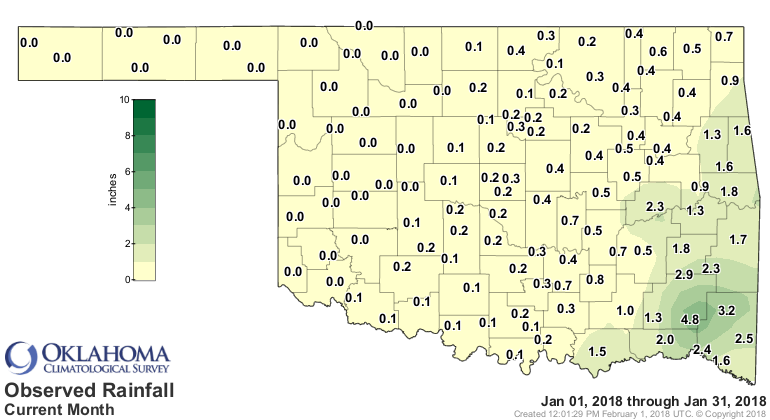
precipitation was especially prominent across western Oklahoma where 19 of the
Oklahoma Mesonet?s 120 stations received no precipitation for the month, and
another 47 saw less than a quarter-inch.
In some cases, the precipitation-free streak extended back to early October.
The Mesonet sites at Woodward and Hooker had gone 113 consecutive days without
a single drop of moisture by the end of January. Not coincidentally, drought
was able to take a huge leap forward during January, and its impacts were
significant. Wildfire danger became a daily worry, and Oklahoma?s winter wheat
crop suffered tremendously. The USDA listed Oklahoma?s winter wheat crop
condition at 79 percent poor or very poor by the end of January, up from 42
percent at the end of December and 10 percent at the end of November. Dry stock
ponds and lack of grazing led to reports of some cattle herds being partially
liquidated. January?s hazardous weather was not all confined to drought and
wildfire, however. Oklahoma saw its first tornado warnings of the new year with
possible twisters in LeFlore and McCurtain counties on Jan. 21, although no
official touchdowns were reported in the preliminary storm reports.
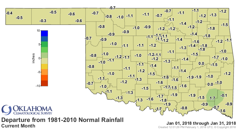
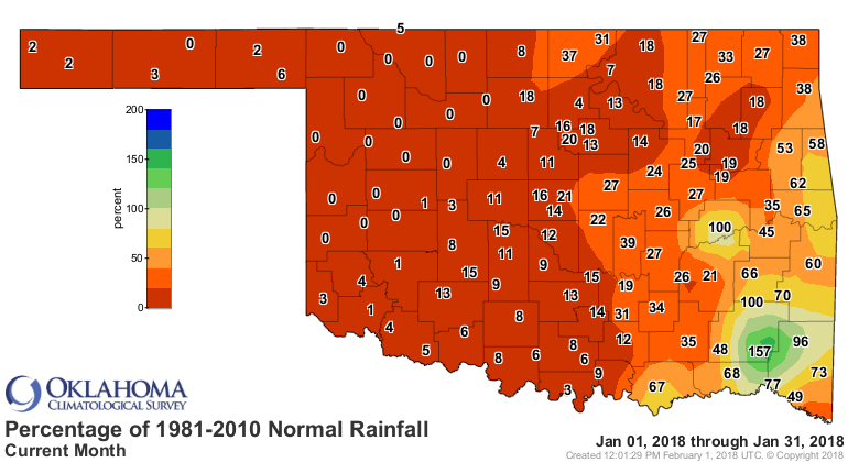
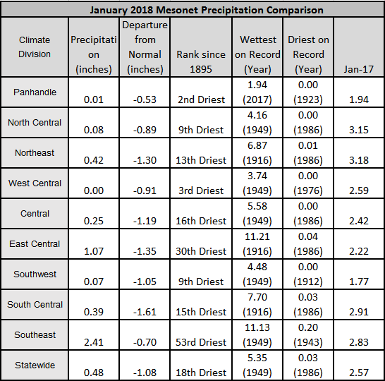
According to preliminary Mesonet data, the January statewide average
precipitation total was 0.48 inches, 1.08 inches below normal and the 18th
driest January since records began in 1895. The Panhandle saw its second driest
January on record, however, with an average total of 0.01 inches. Southeastern
Oklahoma fared the best with an average total of 2.41 inches, 0.7 inches below
normal.
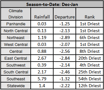
Cloudy led all Mesonet sites with 4.77 inches of rain for January. The
December-January period was the driest on record for the Panhandle, north
central and west central areas of the state. The December-January statewide
average of 1.4 inches was 2.22 inches below normal and the 12 driest such
period on record.
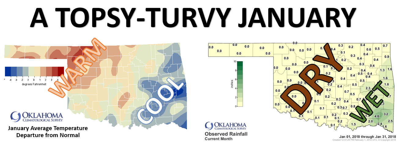
January was a bit on the cool side with a statewide average temperature of 37.1
degrees, 0.6 degrees below normal to rank as the 58th coolest on record. The
northwestern half of the state, under the influence of drought and strong
southerly winds at times, experienced a warmer than normal January while the
southeastern half was cooler than normal.

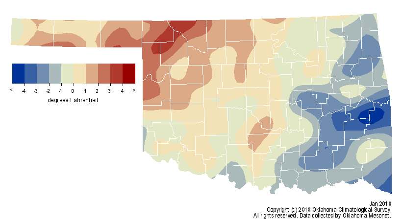
The Panhandle was 1.1 degrees above normal, the 39th warmest on record for that
region of the state. The southeast fell 2.6 degrees below normal to rank as
their 29th coolest. Miami recorded the lowest temperature of the month with
minus 8 degrees on the 17th. Miami?s high temperature on the 16th was a
bone-chilling 8 degrees. Eva led the state with a high of 82 degrees on the
30th.
As noted previously, drought took a huge leap forward during January. According
to the U.S. Drought Monitor, drought covered 76 percent of the state at the
beginning of the month, but only 28 percent was considered ?severe.? By the end
of January, the entire state was considered in at least moderate drought, a
level not seen since March 26, 2013.
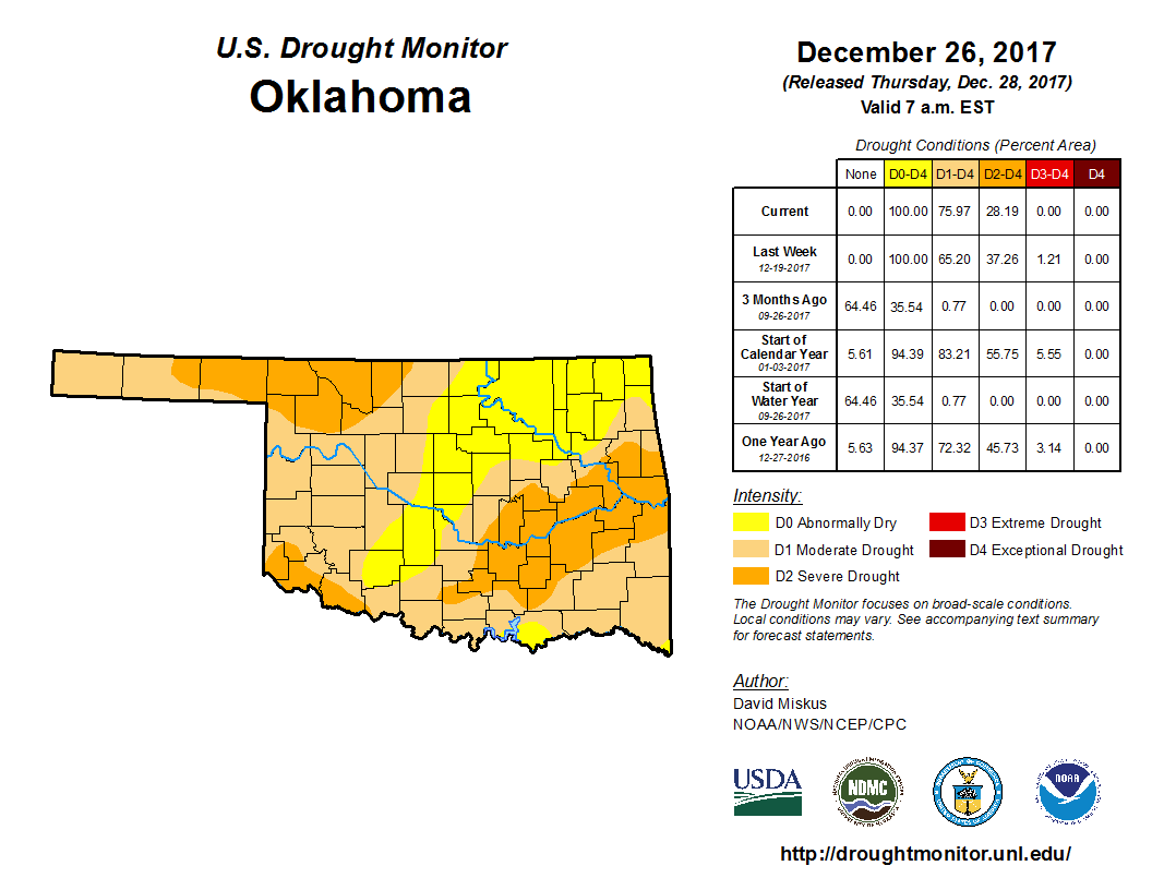
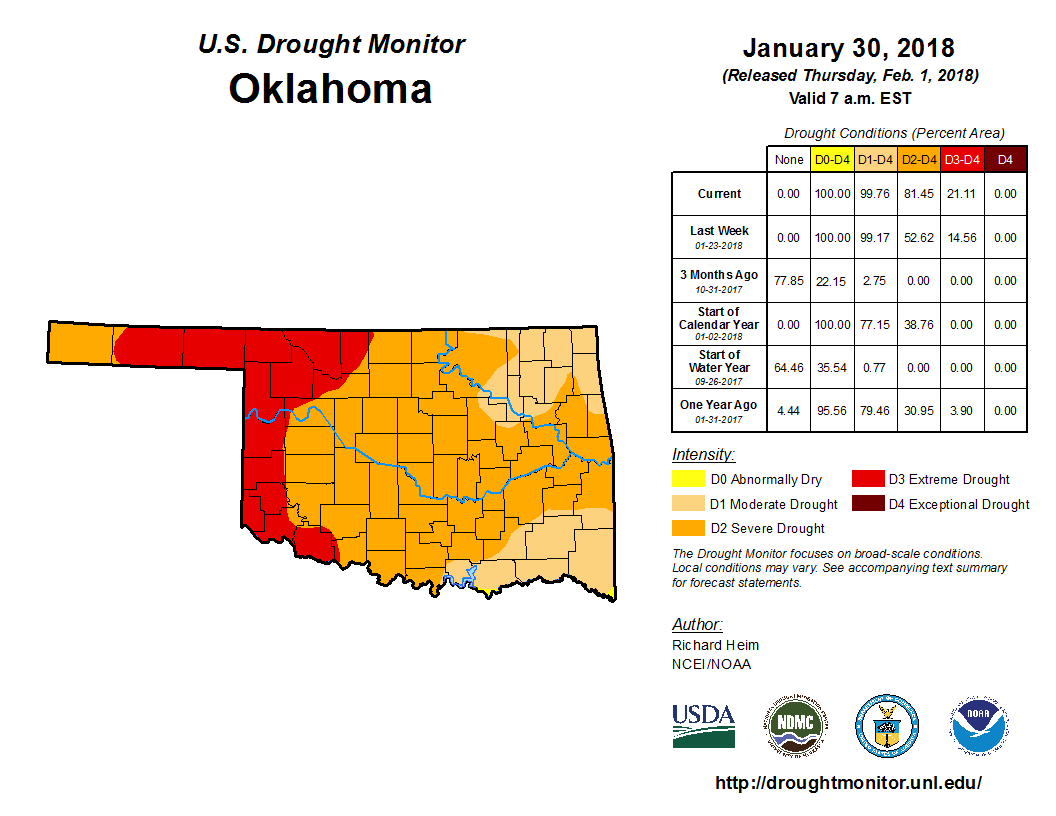
More than 81 percent of the state was in at least severe drought, including 21
percent in the ?extreme? category. The Drought Monitor?s intensity scale slides
from moderate-severe-extreme-exceptional, with exceptional being the worst
classification.
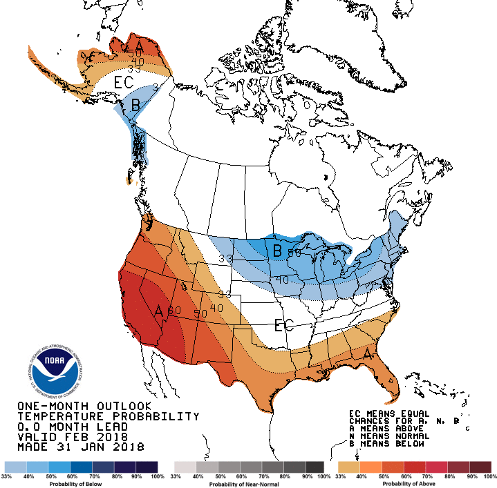
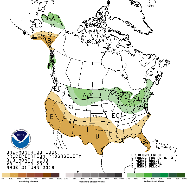
The February temperature and precipitation outlooks from the Climate Prediction
Center (CPC) call for increased odds of above normal temperatures across the
Panhandle and far southwest, and below normal precipitation across the entire
state. Those odds are increased particularly across southwestern Oklahoma.
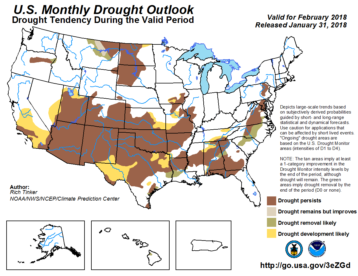
CPC?s drought outlook for February see drought either persisting or
intensifying across the entire state.
Gary McManus
State Climatologist
Oklahoma Mesonet
Oklahoma Climatological Survey
(405) 325-2253
gmcmanus@mesonet.org
February 1 in Mesonet History
| Record | Value | Station | Year |
|---|---|---|---|
| Maximum Temperature | 81°F | SLAP | 2003 |
| Minimum Temperature | -7°F | BOIS | 2011 |
| Maximum Rainfall | 1.61 inches | MTHE | 2011 |
Mesonet records begin in 1994.
Search by Date
If you're a bit off, don't worry, because just like horseshoes, “almost” counts on the Ticker website!