Ticker for December 7, 2017
MESONET TICKER ... MESONET TICKER ... MESONET TICKER ... MESONET TICKER ...
December 7, 2017 December 7, 2017 December 7, 2017 December 7, 2017
RRRAARRWHHGWWR!!
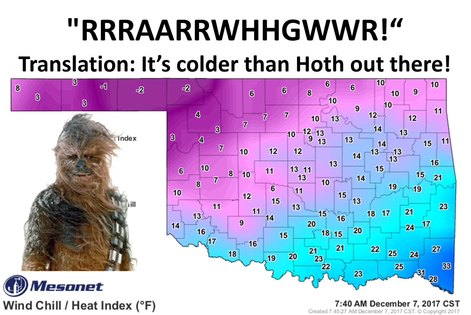
I didn't know, I didn't know! I spent so much time yesterday working on drought
that I had NO CLUE (WATCH IT, PAL!) that we were about to be plunged into an
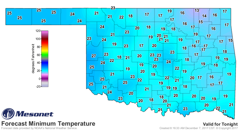
arctic blast of such magnitude. Low temperatures have plummeted thanks to a
reinforcing shot of cold air following Monday's cold front (a day in which we
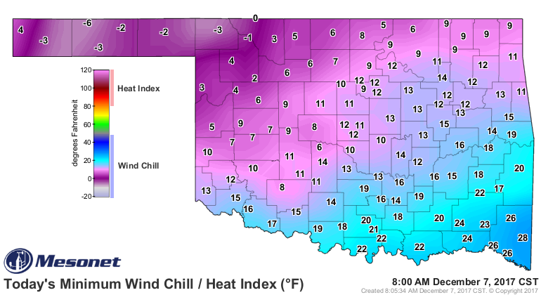
set lots of records for high temps). Wind chills have dropped below zero in the
northwest, and into the single digits and teens across much of the rest of
Oklahoma. And actual air temperatures plummeted into the single digits across
the Panhandle.
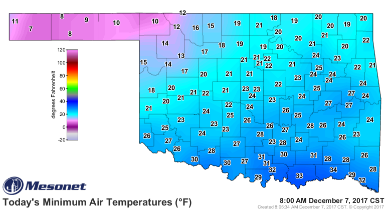
That 7 degrees in Boise City is the coldest reading we've seen on the Mesonet
since it was lower than that. Oh, the date? Well, that was back on Feb. 25 when
Eva dropped down to 5 degrees. Smooth sailing since then. Highs today will jump
back into the...mid-30s? Those were good years, but horrible temperatures.
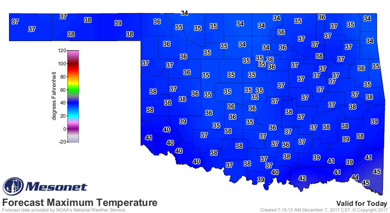
A hard freeze again for the entire state tonight, then a bounce-back into the
60s by this weekend.

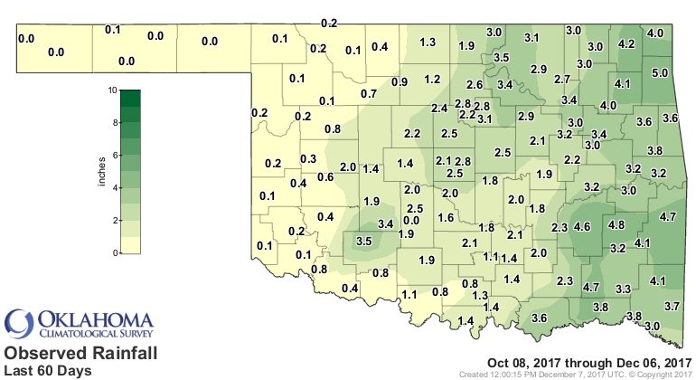
Now what I THOUGHT was going to be the big news of the day was the continuing
intensification of drought across the state. We did get some rain across far
southeastern OK, which forestalled any intensification in that area.
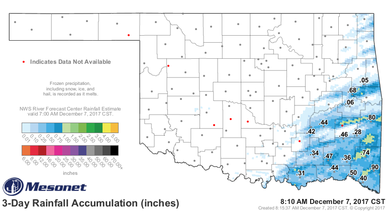
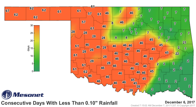
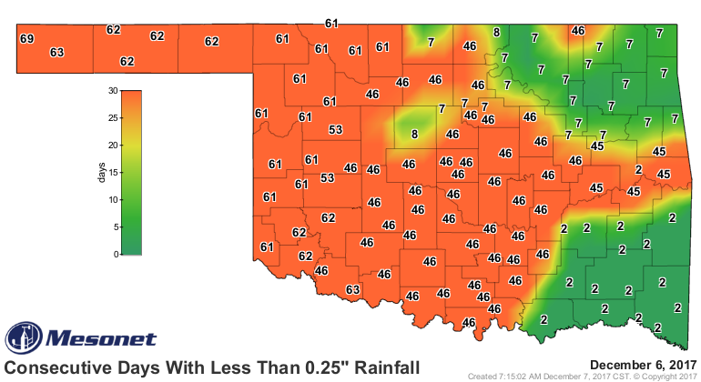
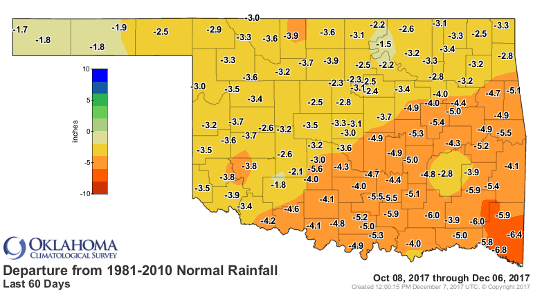
Unfortunately, that's the only rain we've had in ages. And we're still faced
with growing deficits across nearly all the state. After today, it will have
been 70 days (70 DAYS, FOLKS!!) that the western Panhandle has seen at least a
quarter-inch of rain, and it's been between 46-67 days since a bunch of the
state has seen a tenth of an inch.
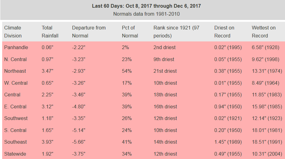
And we're now faced with the 12th driest last-60 days since at least 1921 for
Oklahoma.

Given the reports of drought-stressed crops (especially winter wheat), low or
empty farm ponds, increased fire danger, etc., we asked for another
intensification of drought across the state, and the new Drought Monitor map
ain't pretty.
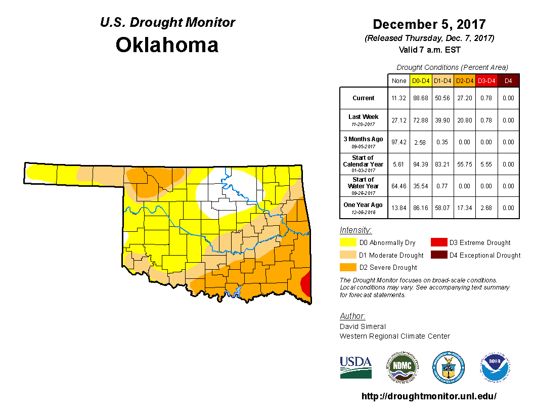
Nearly 51% of the state is now in drought, and nearly all the rest is in
abnormally dry conditions (drought precursor mode). The big stat there is more
than 27% of the state is in at least severe drought.
Now this is important that we start to increase those drought levels on the
Drought Monitor since some ag relief programs are contingent on that drought
designation. We don't take that into consideration when determining drought,
but it works in symbiosis with out depiction since agricultural damage is a
major "ground truth" when determining drought levels. And that's why those
reports from the field we receive here at the Mesonet are so important. It's
very easy for us to sit hundreds of miles away just looking at data and tell
folks what they're experiencing as far as drought...but if you'll re-read the
first part of this sentence, you'll see how ridiculous that statement is.
"Hey, my wheat is rapidly dying off. We're in drought!"
Sorry, I show you with a good rain 78 days ago, so the 90-day rainfall
statistics look pretty good to me. NO DROUGHT.
And it can work in reverse. We can detect drought in the data and declare it
a meteorological drought even though damages aren't apparent in the ag
community. Perhaps it's impacting firefighters? Water managers? Municipal water
supplies?
Just all the fun types of combinations we get to sort through each week with
the Drought Monitor. Of course we'd prefer a blank map...makes our Sunday-
Wednesdays a bit easier. But this is Oklahoma...just doesn't seem to happen
that way.
Gary McManus
State Climatologist
Oklahoma Mesonet
Oklahoma Climatological Survey
(405) 325-2253
gmcmanus@mesonet.org
December 7 in Mesonet History
| Record | Value | Station | Year |
|---|---|---|---|
| Maximum Temperature | 80°F | BURN | 2007 |
| Minimum Temperature | -9°F | BOIS | 2005 |
| Maximum Rainfall | 1.27″ | BBOW | 1997 |
Mesonet records begin in 1994.
Search by Date
If you're a bit off, don't worry, because just like horseshoes, “almost” counts on the Ticker website!