Ticker for August 31, 2017
MESONET TICKER ... MESONET TICKER ... MESONET TICKER ... MESONET TICKER ...
August 31, 2017 August 31, 2017 August 31, 2017 August 31, 2017
The summer without an August
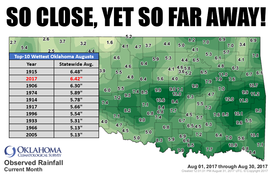
Yeah yeah, it was mild and wet this August. You don't need a ruggedly handsome
State Climatologist to tell you that, and you don't need me telling you that
either. Hey, I have self esteem issues! Meteorologists have all the fun what with
their fancy radars and tornado chasing and...well, I digress. But would it have
hurt to rain just a little bit more? How about a grazing from Hurricane Harvey?
Nothing bad, just another enough to raise our statewide average a few more
hundredths of an inch? Because all we climatologists have for excitement are
records, and we came DARNED close to having our wettest on record this go-round.
We ended up at 6.42 inches, a mere 0.07 inches from breaking 1915's top tally of
6.48 inches.
DOH!
Well, for those that hate heat, it was deliciously mild for you as well. We've
talked about all of this this week, but I've officially summarized the preliminary
numbers through this afternoon and finalized the approximations, so check out
the August summary below the jump.
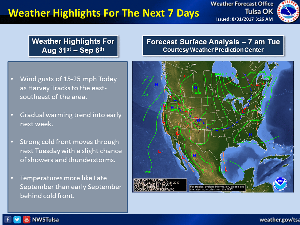
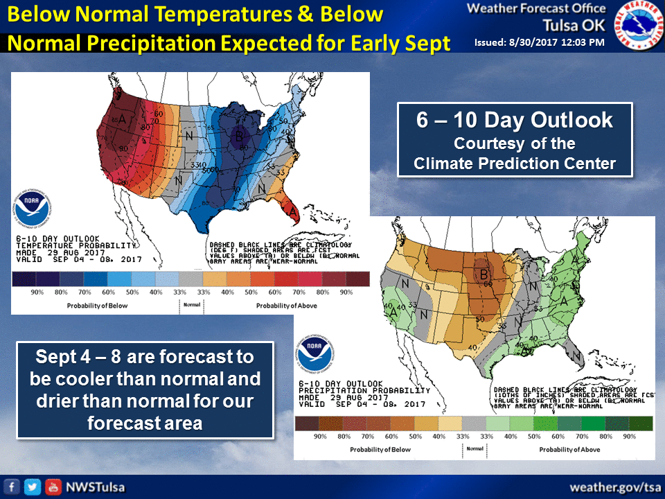
As for the rest of the week through the holiday weekend, here are a couple of
primers from our friends at the Tulsa NWS office. Looks like a brief bite of
summer, then back to our mild ways.
And without further a-dew (weather humor), here's your August summary.
-------------------------------------------------------------------------------
August is often Oklahoma?s most brutal summer month. The spring rains become a
distant memory, heat gains momentum through July, and the state?s landscape
turns a sickly shade of yellow. With drought intensifying along with the heat
this summer, August looked bleak once again. However, Mother Nature was in a
charitable mood. The upper-level heat dome ? a common visitor to the Southern
Plains in late summer ? shifted to the west and brought Oklahoma under
northwesterly flow aloft. That change meant more cool fronts and storm systems
to interact with the rich moisture flowing north from the Gulf of Mexico. With
that favorable pattern in place through much of the month, Oklahoma enjoyed one
of its most mild and wet Augusts on record.
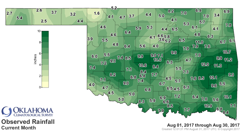
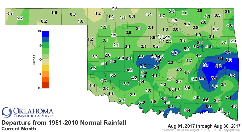
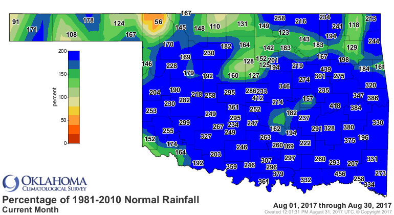
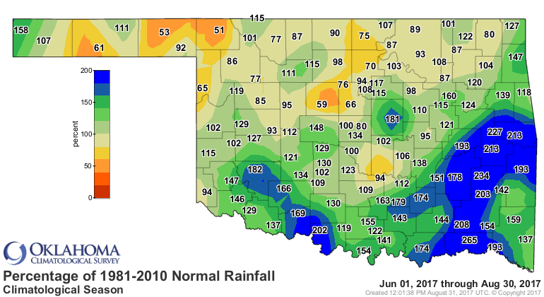
According to preliminary data from the Oklahoma Mesonet, the statewide average
precipitation total was 6.42 inches, 3.47 inches above normal and the second
wettest August since records began in 1895. August 1915 holds the top spot with
6.48 inches. The Oklahoma City East site led the Mesonet with 13.04 inches, but
there were plenty of hefty totals during the month. Ten Mesonet sites recorded
at least 10 inches, and 79 received between 5 and 10 inches. Buffalo had the
lowest total with 1.55 inches.
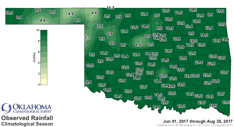
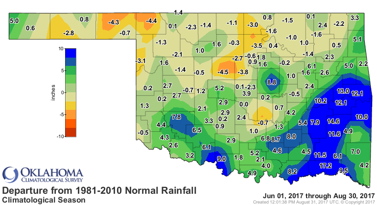
Climatological summer (June 1-Aug. 31) was the 29th wettest on record with a
statewide average of 12.24 inches, 1.89 inches above normal.
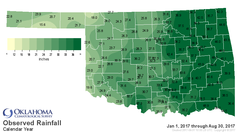
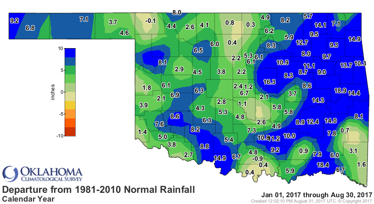
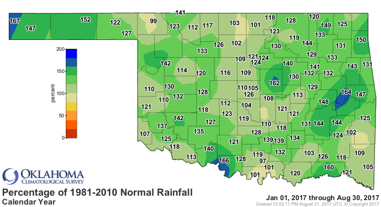
The January-August average of 30.59 inches was 5.73 inches above normal to rank
as the eighth wettest such period on record.
Those that don?t favor summer?s usual fare can thank the string of cool fronts,
abundant rainfall and its associated cloudiness for the delightfully mild
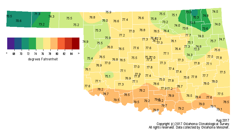
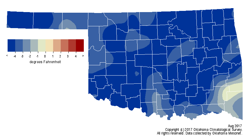
August. According to preliminary data from the Mesonet, the statewide average
temperature was 76.4 degrees, 4.4 degrees below normal to rank as the sixth
coolest August on record.
The Mesonet's 121 stations recorded a temperature of at least 100 degrees
22 times, and those occurred on only two days ? Aug. 5 and Aug. 19. In
comparison, the Mesonet recorded 2,478 triple-digit temperatures during
August 2011, the hottest on record.
Freedom and Kingfisher led the state with 103 degrees on Aug. 5 while Eva had
the lowest temperature at 47 degrees on the month?s final morning.
Climatological summer ended as the 29th coolest on record with a statewide
average of 78.7 degrees, about a degree below normal. The mild August put a
dent in 2017?s march towards a top-10 warmest ranking, but the first eight
months of the year remained 1.8 degrees above normal at 64 degrees, the 11th
warmest January-August on record.
Flooding was the biggest weather hazard Oklahomans faced during August, given
the frequent downpours. Flash flooding resulted in numerous water rescues
across the Oklahoma City area on both Aug. 22 and Aug. 25, and in the Tulsa
area on Aug. 15. The Tulsa area faced a more violent weather hazard early on
the sixth with the touchdown of four tornadoes. The strongest tornado, rated an
EF-2 on the Enhanced Fujita scale, injured more than two dozen people and
caused significant damage to businesses in the midtown Tulsa area. Three
additional EF-1 tornadoes struck Broken Arrow, Chelsea, and Oologah. Drought
impacts virtually disappeared thanks to the generous rainfall amounts.
According to the U.S. Drought Monitor, 19 percent of the state was considered
in drought and another 30 percent abnormally dry at the beginning of the month.
Drought had been totally eliminated and only two percent of the state was still
abnormally dry by the end of August.
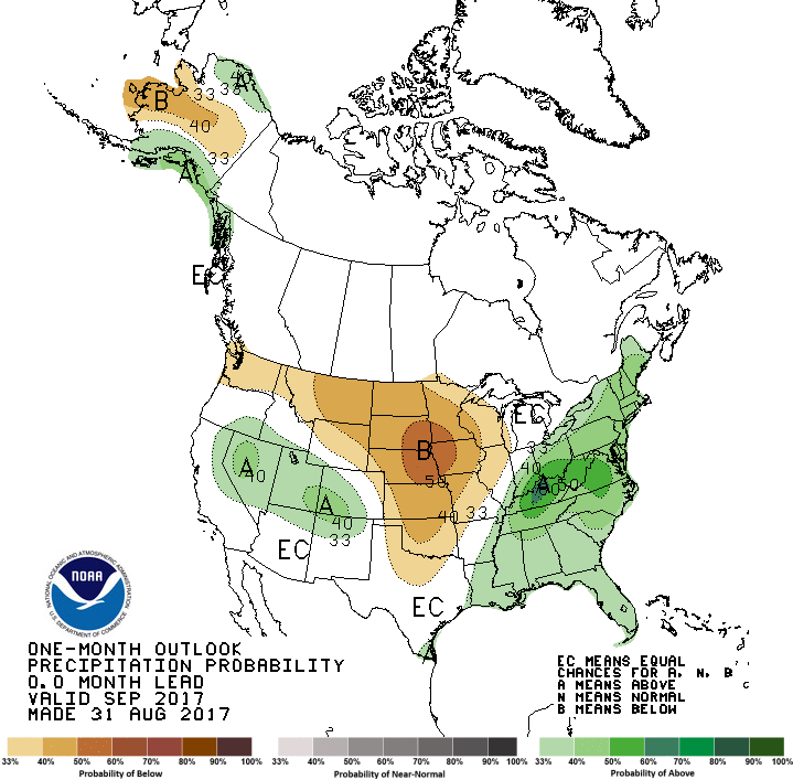
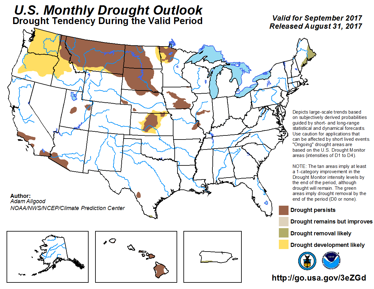
The September outlooks from the Climate Prediction Center (CPC) indicate
increased odds of below normal temperatures and precipitation across most of
the state. However, no drought is expected to develop over the next month
according to CPC?s September Drought Outlook.

Gary McManus
State Climatologist
Oklahoma Mesonet
Oklahoma Climatological Survey
(405) 325-2253
gmcmanus@mesonet.org
August 31 in Mesonet History
| Record | Value | Station | Year |
|---|---|---|---|
| Maximum Temperature | 111°F | FREE | 2011 |
| Minimum Temperature | 45°F | NOWA | 2009 |
| Maximum Rainfall | 5.29″ | YUKO | 2020 |
Mesonet records begin in 1994.
Search by Date
If you're a bit off, don't worry, because just like horseshoes, “almost” counts on the Ticker website!