Ticker for May 1, 2017
MESONET TICKER ... MESONET TICKER ... MESONET TICKER ... MESONET TICKER ...
May 1, 2017 May 1, 2017 May 1, 2017 May 1, 2017
April Madness
I don't know what else to say. The Panhandle is still without power after a foot
or so of snow (some more, some less) and 70 mph winds (again, some more, some
less), folks in eastern Oklahoma are swimming from their bedrooms to their
kitchens, and the arch at the State Fairgrounds in OKC got obliterated by
80+ mph winds. That about cover it? The whole state is a disaster area!!
No, really, Governor Fallin declared a State of Emergency for all 77 counties,
and if there was ever a state that could be labeled "Emergency," Oklahoma
often applies.
Broken records abound...still waiting for official numbers for snow from the
Panhandle. For those wondering, Boise City recorded a 12-inch snowfall on May
3, 1978, so that record gets a bit murky (frozen, but murky). You can read more
about April from start to finish below, and in this case, it really was start
to finish!
----------------------------------------------------------------------------------
April Weather Runs the Gamut
May 1, 2017
April took its penchant for widely varying weather to near satirical extremes
across Oklahoma. Floods, tornadoes, drought and blizzards ? Mother Nature pulled
out all the stops to give Oklahoma nearly the entire gamut of weather hazards.
As many as six separate storm systems traversed the state during April, but the
worst was saved for last. A powerful upper-level storm impacted state from the
28th through the 30th. Widespread rainfall amounts of 3-6 inches produced
flooding from southwestern through northeastern Oklahoma. Portions of eastern
Oklahoma received more than 8 inches over the two-day period.
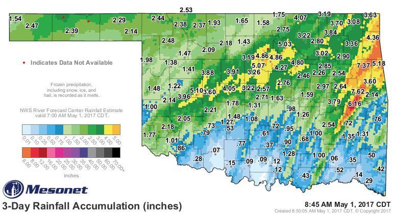
Numerous water rescues were necessary across the state. Severe storms produced
large hail, damaging winds and a few tornadoes throughout the event. The
historic arch at the State Fairgrounds in Oklahoma City was toppled by winds
gusting to over 80 mph. Downed trees and power lines led to 40,000 utility
customers losing power at the height of the storm. Several tornadoes were also
reported with the storms across eastern Oklahoma. While it was flooding across
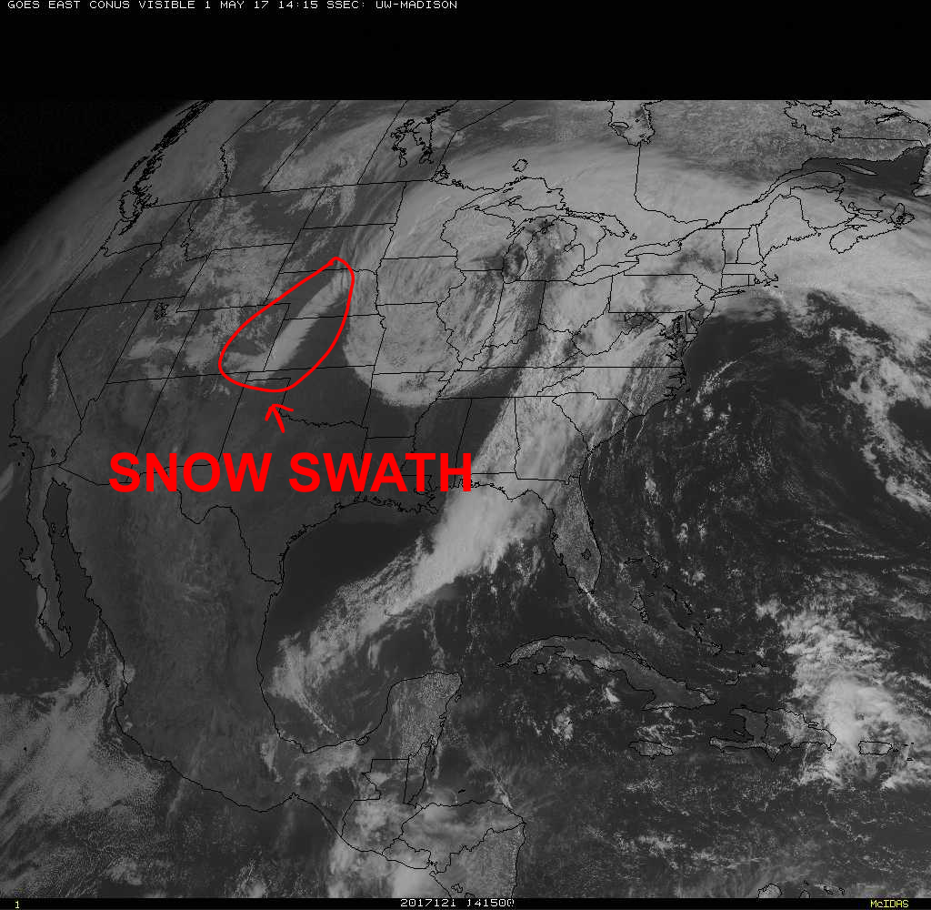
the main body of the state, the Panhandle was experiencing an old fashioned
High Plains blizzard. More than a foot of snow was reported in the far western
Panhandle, while 4-8 inches fell farther to the east. The Cimarron County
sheriff?s department reported 15 inches of snow and drifts of 5 feet. The snow
was whipped by winds gusting up to 70 mph on Sunday to create white-out
conditions, closing roads and stranding travelers. Blizzard warnings were issued
for Cimarron and Texas counties.
Due to the scope of the storm system across the state, Governor Mary Fallin
declared a state of emergency for all 77 counties.
Each succeeding system during the month added moisture to an already saturated
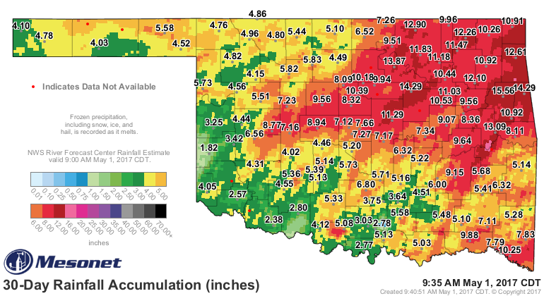
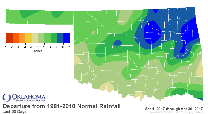
Oklahoma. According to preliminary data from the Oklahoma Mesonet, the statewide
average precipitation total was 6.82 inches, 3.56 inches above normal and the
third wettest April since records began in 1895. Totals ranged from 1.82 inches
at Erick in far western Oklahoma to 15.56 inches at Tahlequah in the east.
Eighty-seven of the 121 Mesonet sites recorded at least 5 inches of rain, and
25 of those stations recorded more than 10 inches. All but seven Mesonet sites
recorded at least 3 inches. Northeast Oklahoma saw its wettest April on record
with an average of 11.3 inches, shattering the previous record of 9.27 inches
set back in 1942. Tulsa broke its record for April rainfall with 10.44 inches,
eclipsing the 9.33 inches from 2008.
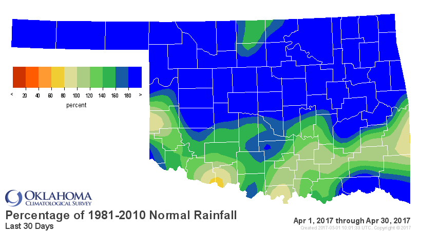
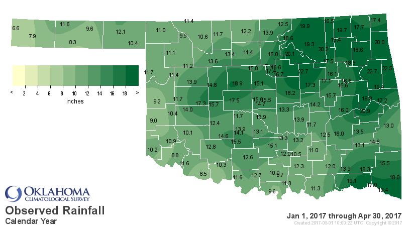
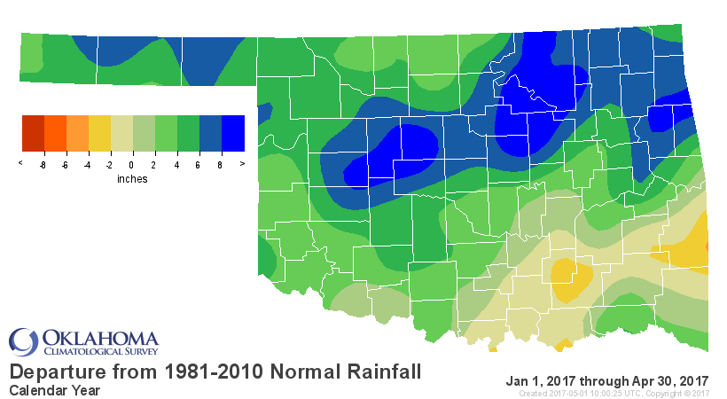
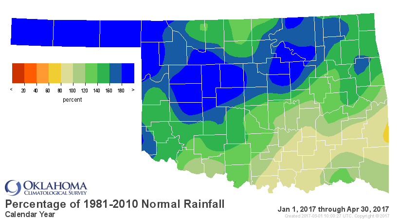
In addition to the snow received at the end of the month, the Panhandle
recorded another 4-8 inches on April 2, exceeding their totals for the five
previous months combined. The robust April precipitation totals propelled the
January-April statewide average to the sixth wettest on record at 14.02 inches.
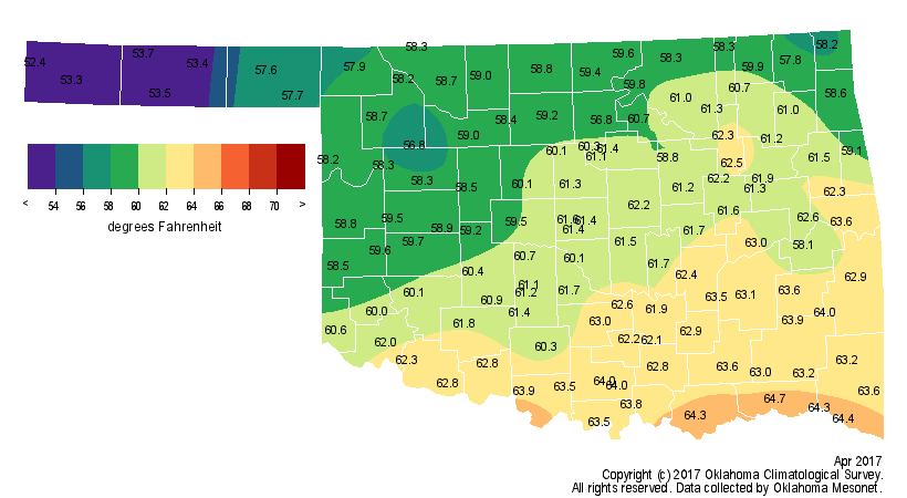
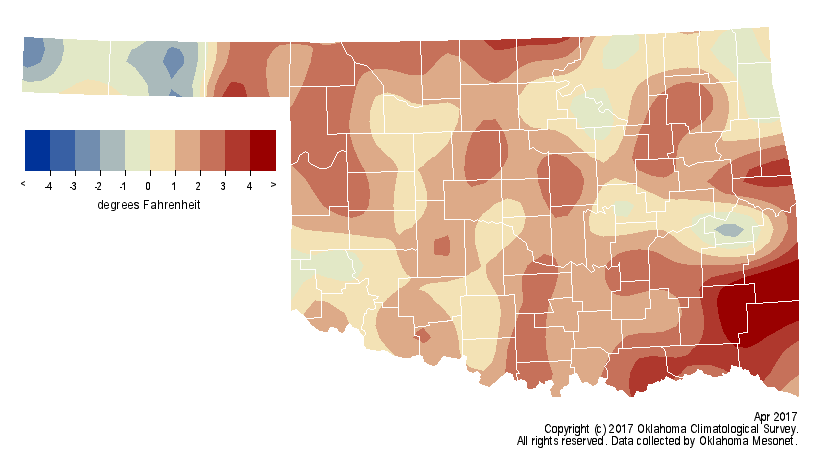
Despite the momentary bouts with winter, April?s statewide average temperature
still managed to finish 1.1 degrees above normal at 60.4 degrees, the 44th
warmest April on record. The highest temperature recorded was 94 degrees at
Beaver on the 19th. The lowest temperature, 28 degrees, was recorded at Kenton
on April 2 and again at Eva on the 23rd. The January-April statewide average
temperature was 51.9 degrees, 4.5 degrees above normal and the third warmest
such period on record.
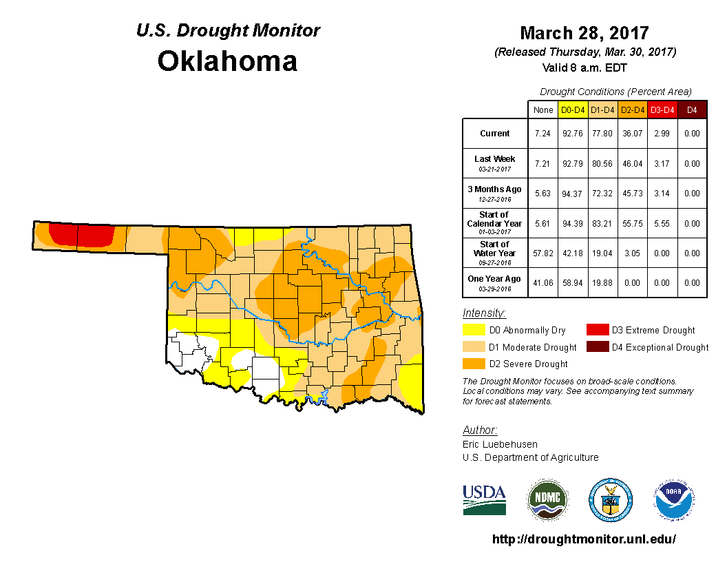
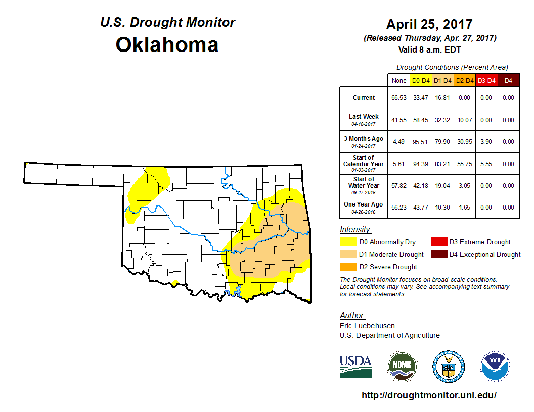
Drought took a major hit during April. The final U.S. Drought Monitor map of
the month depicted a mere 17% of the state experiencing drought, a drop from
78% on March?s final map. That is the smallest percentage of the state in
drought since Oct. 11, 2016. A portion of the drought that remained received
significant rainfall during the month?s final days, so more drought removal is
likely.
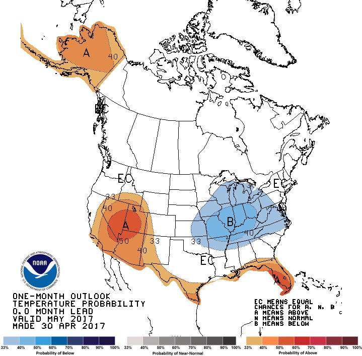
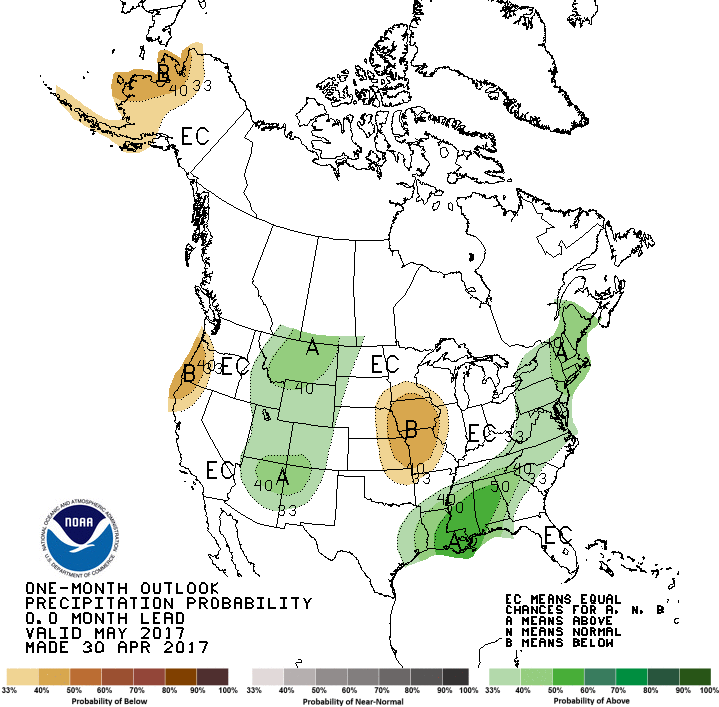
The latest outlooks for May from the Climate Prediction Center (CPC) yield few
clues for Oklahoma, although they do show slightly increased odds of below
normal precipitation and temperatures for far northeastern Oklahoma. That last
bastion of drought across eastern Oklahoma is expected to improve by the end of
May according to CPC?s U.S. Drought Outlook, with removal likely.
Gary McManus
State Climatologist
Oklahoma Mesonet
Oklahoma Climatological Survey
(405) 325-2253
gmcmanus@mesonet.org
May 1 in Mesonet History
| Record | Value | Station | Year |
|---|---|---|---|
| Maximum Temperature | 101°F | ALTU | 2002 |
| Minimum Temperature | 28°F | BOIS | 2011 |
| Maximum Rainfall | 7.70″ | PRYO | 2009 |
Mesonet records begin in 1994.
Search by Date
If you're a bit off, don't worry, because just like horseshoes, “almost” counts on the Ticker website!