Ticker for February 15, 2017
MESONET TICKER ... MESONET TICKER ... MESONET TICKER ... MESONET TICKER ...
February 15, 2017 February 15, 2017 February 15, 2017 February 15, 2017
Sunshine!
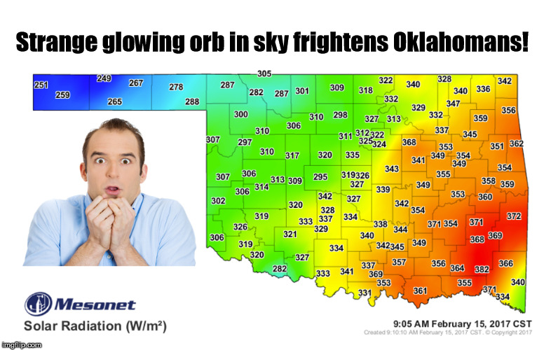
Not since the "Great Glowing Orb Outbreak of May 11" have I seen something so
frightening...a strange, luminescent yellow ball of fire in the sky. As I stared
at it on my drive in, I noticed that my eyes started to hurt, so I kept staring at
it until I finally figured out what it is. The sun! Yes, even though it has been
missing for the last few days, those old adages are true...the sun really does
come up tomorrow. Strange thing about that Mesonet solar radiation map above...
why was the SR so much higher in eastern Oklahoma? Ahhhh, another mystery. The
satellite map showed clear skies across the state, so no loss due to clouds.
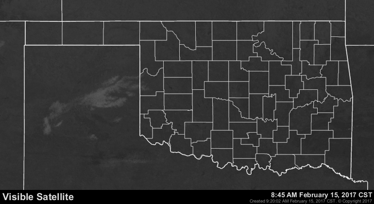
By the way...that white you see out in the Texas Panhandle is no doubt leftover
snowfall from yesterday. How can I tell? Just one of the perks of being the Master
of all Space and Time (#humblebrag). Well, that and the outline is clearly
indicative of terrain and not cloudiness. But back to the current mystery. I've
researched all morning, consulted experts from across the country and I think I've
come up with a fascinating hypothesis. It turns out the sun rises in the east so
the solar radiation is highest in the east in the morning!
SCIENCE!
Okay, back to our regularly scheduled programming...the storm system finally
moved off to the east and left us with a decent/good/great swath of rain across
the state. The degree of awesomeness depends on where you are in the state,
although I think we have ascertained that it's always awesome in the Panhandle,
regardless of rainfall amounts. South of I40 and also SE of I44 was probably
the happiest areas. Even north of I40 about a county or three got an inch or so.
Far NW OK missed out this time, unfortunately.
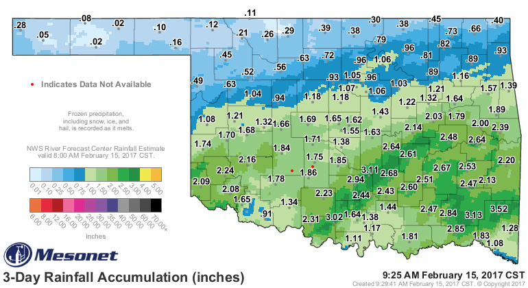
This put a big dent in the dry weather we've been experiencing across
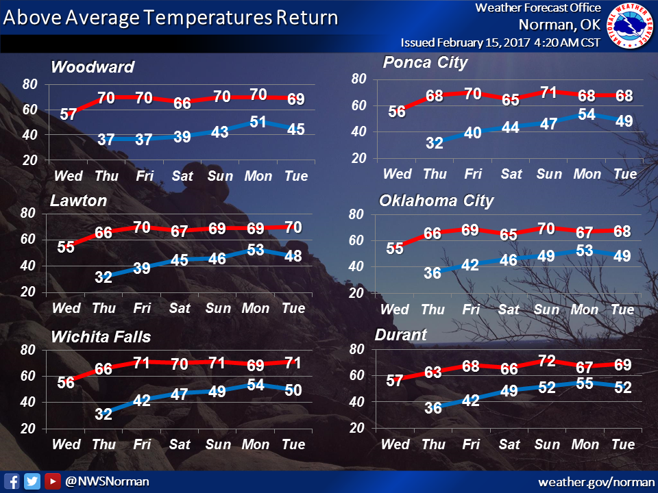
southern Oklahoma. Farther north, reinforcing moisture. Now we get a nice
warm up with lots of sun before our next chance of rain late in the weekend.
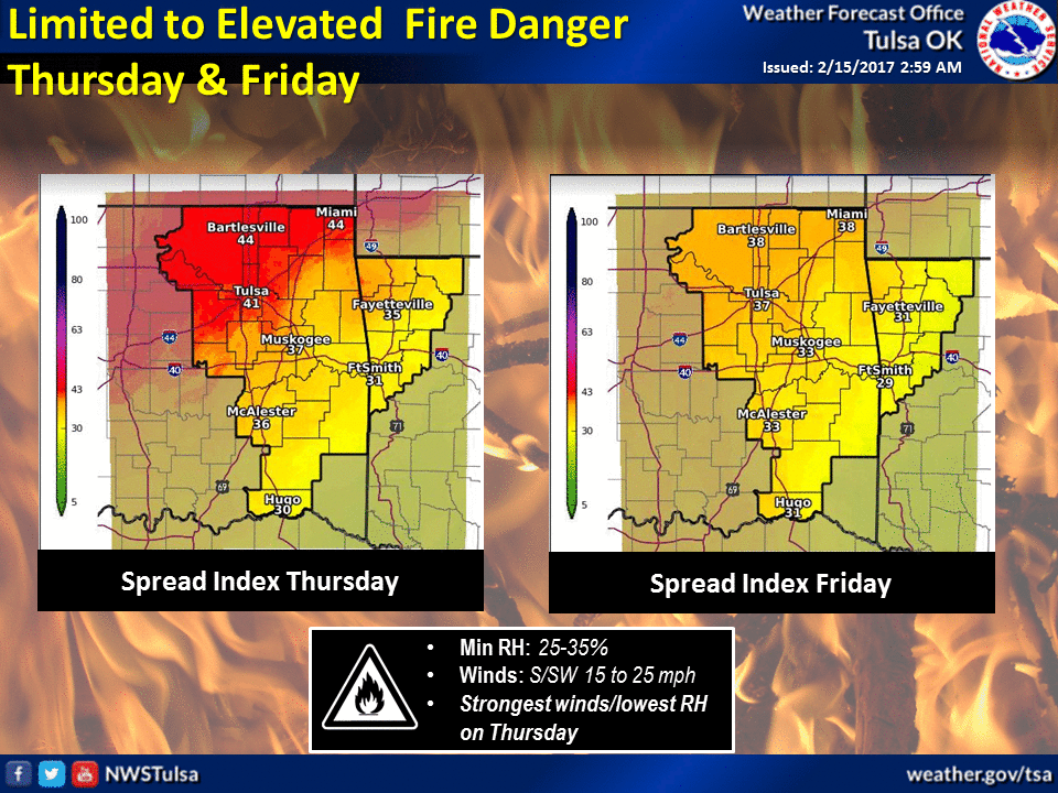
And before you stop thinking about fire danger...uh uh uh. As reminded by the
Tulsa NWS folks, it will be back. Fire danger during the cool season, when all
the finer fuels are dead and/or dormant, is not a function of drought and/or
wetness as much as it is day-to-day weather conditions. You can actually have
rain in the morning and wildfires in the afternoon if those fine fuels (grasses
and such) dry out fast enough. That's why the spring green up is the key to
ending wildfire season.
Precipitation amounts for next week still uncertain, but it's a double-dose
of drought killer.
Gary McManus
State Climatologist
Oklahoma Mesonet
Oklahoma Climatological Survey
(405) 325-2253
gmcmanus@mesonet.org
February 15 in Mesonet History
| Record | Value | Station | Year |
|---|---|---|---|
| Maximum Temperature | 86°F | BURN | 2000 |
| Minimum Temperature | -22°F | KENT | 2021 |
| Maximum Rainfall | 2.12″ | CLOU | 2001 |
Mesonet records begin in 1994.
Search by Date
If you're a bit off, don't worry, because just like horseshoes, “almost” counts on the Ticker website!