Ticker for June 20, 2016
MESONET TICKER ... MESONET TICKER ... MESONET TICKER ... MESONET TICKER ...
June 20, 2016 June 20, 2016 June 20, 2016 June 20, 2016
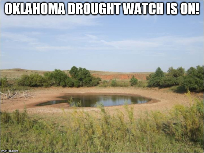
Drought watch is officially ON
I've waited as long as I possibly could, but I think it's about time to officially
(i.e., non-officially) put parts of Oklahoma in a "Flash Drought Watch."
No, there is no such thing as a flash drought watch, so consider this a friendly
little warning (whoops, I meant watch) from your friendly local state
climatologist/drought whisperer, friends. I've waiting about as long as I could
to see our May through mid-June primary rainy season to smother the state in
beneficial rainfall, but it just hasn't happened. Sure, parts of the state have
been inundated with heavy rains on a regular basis, to sometimes disastrous
results. Southern Oklahoma in particular will be laughing at any flash drought
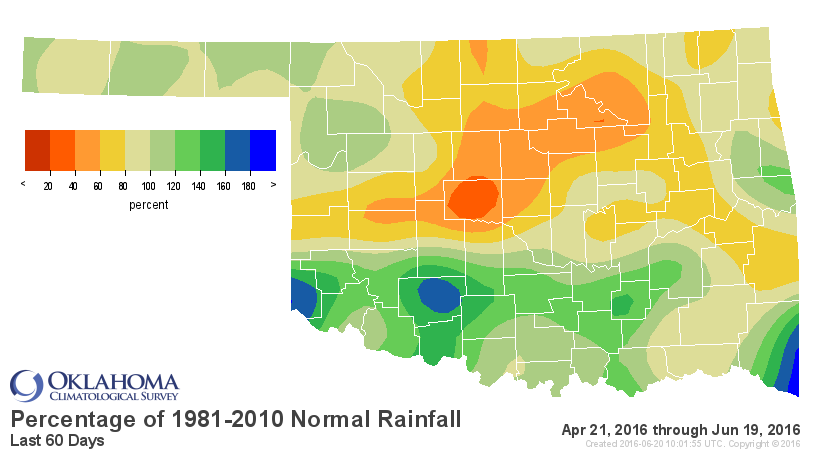
suggestions, But check out the rainfall maps from the last 30- and 60-days and
tell me northern Oklahoma ain't worried.
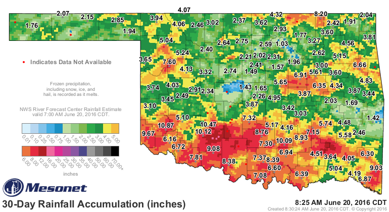
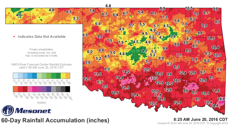
Wow, pretty impressive, right? Lots of magentas, maroons, reds and oranges on the
map, mostly across the southern half of the state. But what about those greens
and yellers farther to the north, centered on Canadian County and stretching north
and east from there? Well, the danger shows up when you look at the percent of
normal maps from the same periods, and then the BAD oranges and reds and yellers
start to show up.
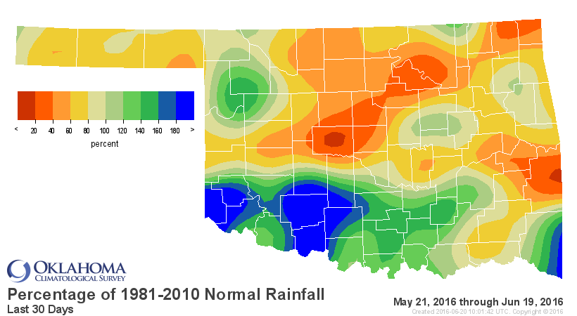
Yikes! And the stats show the disparity between north and south as well.
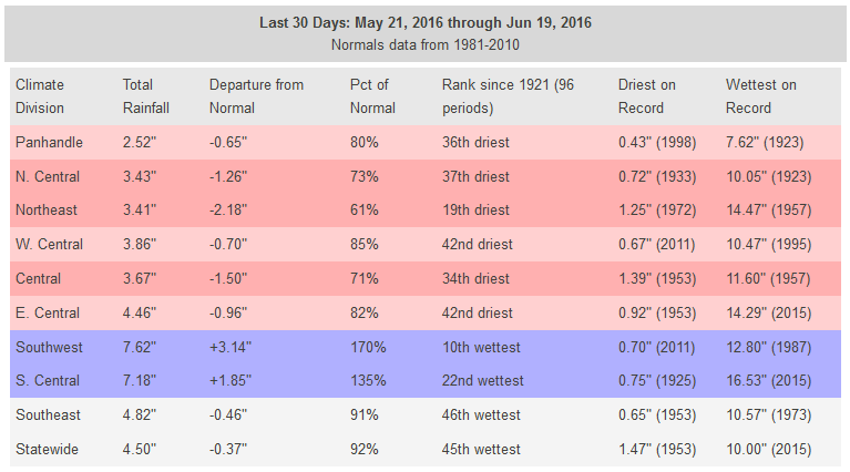
At 30 days, we see the 19th driest such period in the northeast since at least
1921, over 2 inches below normal, vs. the 10th wettest in the southwestern
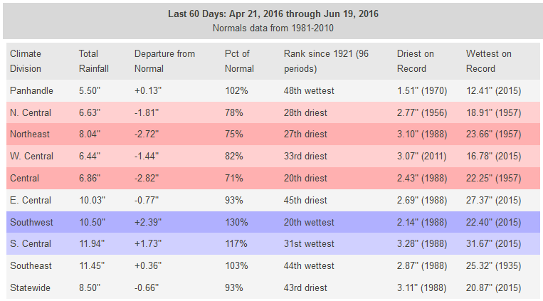
section of the state over 3 inches above normal. And at 60 days we see the 20th
driest period for central OK vs. the 20th wettest in the SW, nearly 3 inches
below normal vs. more than 2 inches above normal, respectively.
Now you may be saying to yourself "But Gary, it's summer. It's supposed to be
dry."
Well, first of all, if your name is Gary, that's okay. If it's not, you should
really not be calling yourself that. Seek help.
But second, and more importantly, it's not NOW that we're worried about being
dry, it's throughout the primary rainy season for most of Oklahoma. In other
words, THE LAST 30-60 DAYS!
Two important caveats to remember:
1) May was very cool across the state of Oklahoma, so the lack of heat helped
stop the normal warm season impacts of rainfall deficits, such as evaporation
and stress to crops, soils and reservoirs.
2) We've entered into an early summer doldrums pattern with a large area of
high pressure camped over the region, oscillating back and forth from west to
east. When it camps over us, it's gonna get hot. Really hot. When it moved west
or north or any direction where we're not right under the core of the high
pressure system, it will merely be "hot." And if it moves off far enough, we can
get an occasional cold front or two and chances for storms.
Now a caveat on that last caveat...they will be summer style storms, meaning
with the loss of strong upper-level flow the storms that go up will tend to
blow up in one spot and sort of just sit there, dumping heavy rains in one area
but not spreading much. Hence the acne-style rainfall pattern we saw over the
last few days with these style of storms.
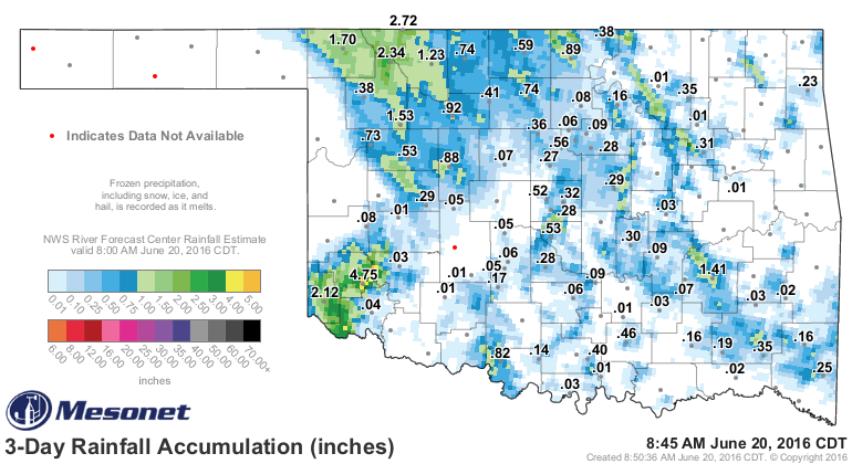
Other than that broader area of rain across the far NW and SW, most of those
rains, while sometimes heavy, didn't meander much from their points of origin.
But 4.75 inches in Mangum? Very impressive.
So we will now need to be on the watch for flash drought development across
parts of the state, particularly from central OK up through the NE. The heat
is on, evaporation will be at a premium.
Chances of rain, while not zero in a few days, do not look great nor widespread
enough to end this danger of flash drought. In fact, you can see that "ring of
fire" signal from the heat dome showing up in the 7-day rainfall forecast as
the sinking air of that high pressure suppresses clouds and rain chances.

I won't try to go out farther than that because summer precip forecasting is
hardly even a science, it's more of a wish-list. But at some point, we have to
acknowledge that forecasting SUMMER itself in Oklahoma is fairly
straightforward...it's usually hot, it's usually dry. Building off of what we've
seen in the last 60 days, that's a cause for concern.
And remember, we may follow up summer with La Nina impacts (warm, dry) for the
fall and winter.
Gary McManus
State Climatologist
Oklahoma Mesonet
Oklahoma Climatological Survey
(405) 325-2253
gmcmanus@mesonet.org
June 20 in Mesonet History
| Record | Value | Station | Year |
|---|---|---|---|
| Maximum Temperature | 112°F | MANG | 1998 |
| Minimum Temperature | 52°F | KENT | 2000 |
| Maximum Rainfall | 4.32 inches | BOWL | 2007 |
Mesonet records begin in 1994.
Search by Date
If you're a bit off, don't worry, because just like horseshoes, “almost” counts on the Ticker website!