Ticker for December 1, 2015
MESONET TICKER ... MESONET TICKER ... MESONET TICKER ... MESONET TICKER ...
December 1, 2015 December 1, 2015 December 1, 2015 December 1, 2015
November Tornadoes, Ice Wreak Havoc Across Oklahoma
Records were threatened, tornadoes were spotted, and ice crippled half of the
state while the other half flooded, all thanks to two powerful storm systems
during one of the wildest stretches of November weather in state history. The
first system struck around mid-month and resembled a classic springtime severe
weather setup. A series of supercells sprung up across the High Plains and
headed east, dropping as many as five tornadoes in Oklahoma and many more across
Texas and Kansas. The system then produced a squall line that marched across the
state with heavy rainfall, large hail and severe winds. An estimated gust of 80
mph was reported near Hydro late on the 16th, and the Mesonet site at Red Rock
recorded a gust of 99 mph early on the 17th. In its final act, the backside of
the storm produced blizzard conditions across the High Plains, including
Cimarron County where Boise City reported 6 inches of snow and visibilities
down to one-eighth of a mile at times. Two other tornadoes had touched down
previously on the fifth to bring the month?s preliminary total to seven and the
annual total to 105.
The second storm system came just in time for the Thanksgiving holiday, slowly
approaching from the west as strong southerly winds pumped abundant moisture
into the Southern Plains from the Gulf of Mexico. This storm system also had
help from the remnants of Pacific Hurricane Sandra which had moved northwest
into Mexico. A strong cold front blasted thorough the state, setting the stage
for a bout with freezing rain, sleet and flooding rainfall. Interstate 44
seemed to be the general dividing line between ice versus liquid water as the
freezing line slowly fluctuated to the northwest and southeast. Radial ice
thicknesses of more than an inch were reported in parts of western and central
Oklahoma, particularly across Grady, Canadian and western Oklahoma counties.
Widespread tree damage was reported, and more than 150,000 electrical utility
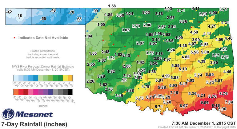
customers were without power at one point. The pervasive flooding in the
southeastern half of the state was somewhat overshadowed by the ice. While the
northwestern one-half of the state saw from 2-4 inches of moisture, the
southeastern half reported widespread amounts of 4-8 inches, with Hugo leading
the way at 9.84 inches.
Governor Fallin declared a state of emergency for all 77 counties in Oklahoma
due to the ice and flooding.
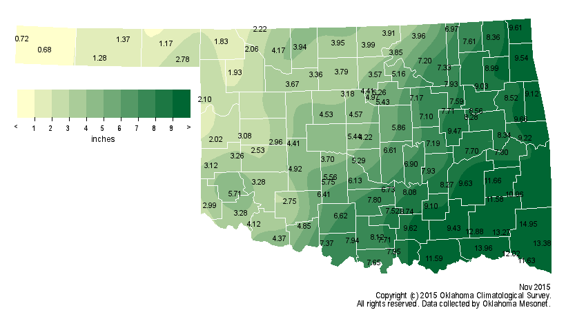
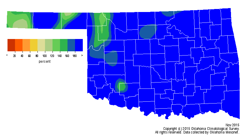
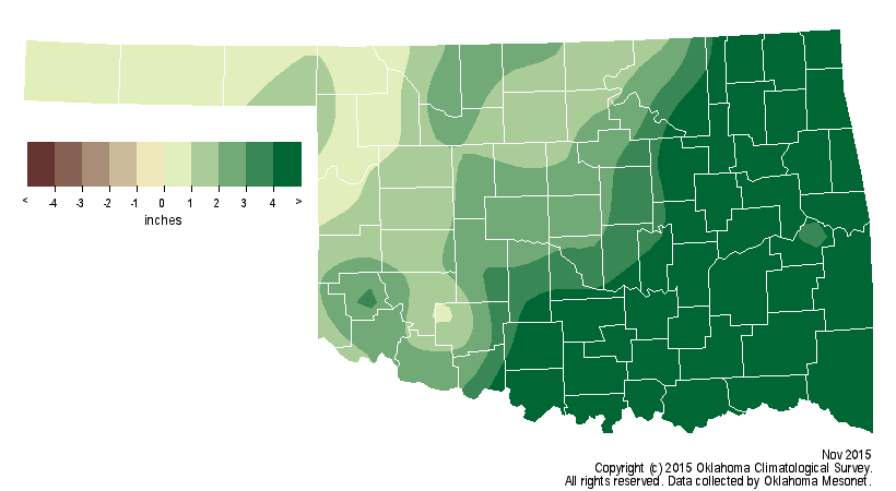
The rain from those two systems spurred the statewide average for November to
historic levels. According to preliminary data from the Oklahoma Mesonet, the
month tied 2004 as the wettest November since records began in 1895 with a
statewide average of 5.97 inches, 3.46 inches above normal. Mt. Herman led the
Mesonet with 14.95 inches, although 10 additional sites had at least 10 inches
of rainfall.
The January-November statewide average surged into first place with the
additional moisture at 47.53 inches, 13.09 inches above normal.
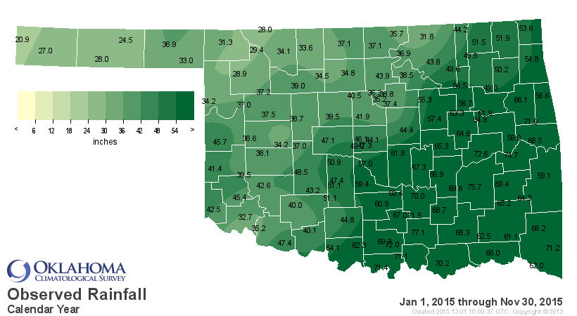
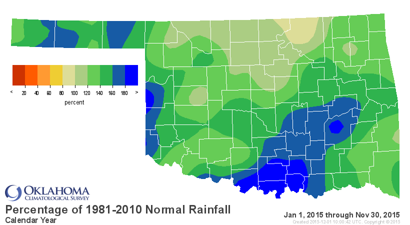
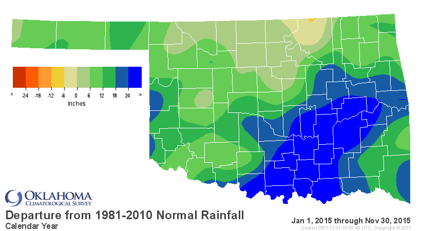
That leaves 2015 just 0.35 inches behind 1957?s mark of 47.88 inches as
Oklahoma?s wettest calendar year on record. The Tishomingo Mesonet site has
recorded 77.1 inches for the year thus far, enough to break the Mesonet?s
calendar year record of 76.41 inches from Broken Bow in 2009. The Mesonet?s
precipitation records date to 1994. The NWS cooperative observing site at
Tuskahoma holds the record for highest annual total for any observing site in
the state with 88.27 inches in 1990. Those records date back to the 1880s. By
the end of November, drought was all but eliminated in the state thanks to the
abundant moisture.
Despite the late-month arctic plunge, temperatures were well above normal
during November with a statewide average of 50.8 degrees, 1.5 degrees above
normal to rank as the 27th warmest on record.
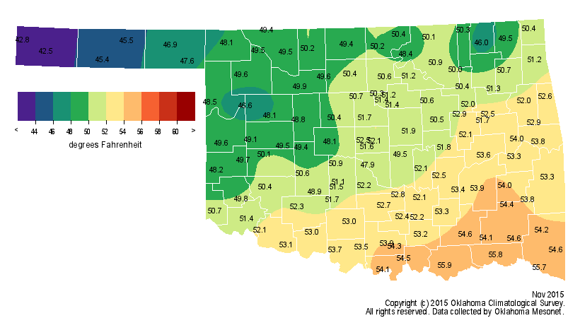
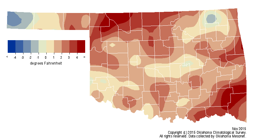
The January-November average of 62.5 degrees stood 0.6 degrees above normal to
rank as the 34th warmest such period on record.
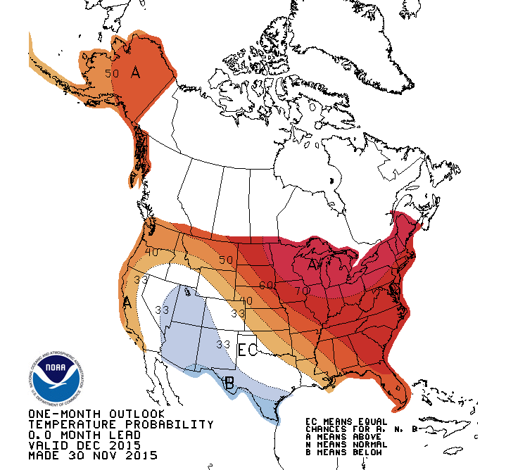
The December outlooks from the Climate Prediction Center call for increased
odds of above normal precipitation across the western half of the state and
above normal temperatures over most of the state.
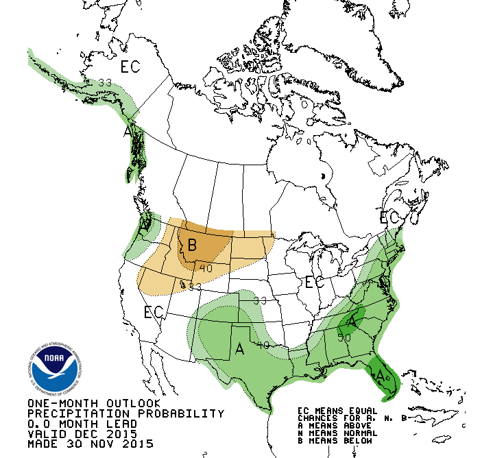
The odds of wetter than normal weather were projected to continue through
early spring, especially across the western half of the state.
http://www.cpc.ncep.noaa.gov/products/predictions/long_range/
Gary McManus
State Climatologist
Oklahoma Mesonet
Oklahoma Climatological Survey
(405) 325-2253
gmcmanus@mesonet.org
December 1 in Mesonet History
| Record | Value | Station | Year |
|---|---|---|---|
| Maximum Temperature | 86°F | HOLL | 2012 |
| Minimum Temperature | 0°F | SEIL | 2006 |
| Maximum Rainfall | 0.75″ | WATO | 2015 |
Mesonet records begin in 1994.
Search by Date
If you're a bit off, don't worry, because just like horseshoes, “almost” counts on the Ticker website!