Ticker for July 1, 2015
MESONET TICKER ... MESONET TICKER ... MESONET TICKER ... MESONET TICKER ...
July 1, 2015 July 1, 2015 July 1, 2015 July 1, 2015
Tropics bring Oklahoma soggy June
Mother Nature turned off the spigot and cranked up the heat during the first 10
days of June, allowing swollen streams, rivers and reservoirs to slowly recede
after the record May rains. The respite was short-lived, however, thanks to a
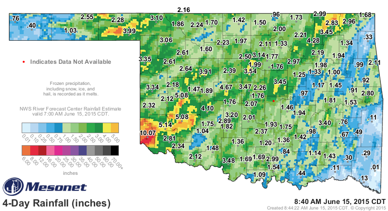
tropical invasion from both the Pacific and Atlantic. First up was the remnant of
hurricane Blanco from the Pacific that interacted with a stalled front and dumped
2-4 inches of rain over a wide swath of the state, including more than 10 inches
near Hollis in far southwestern Oklahoma.
Almost directly thereafter, the Gulf of Mexico offered up the remnant of tropical
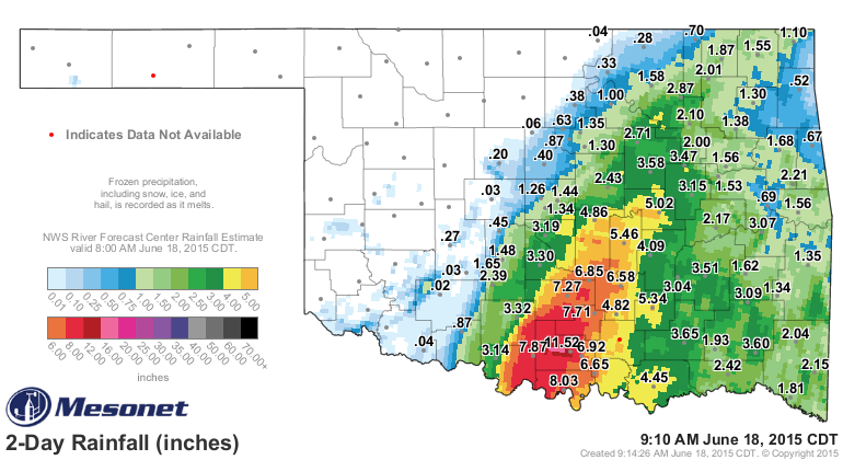
Storm Bill. That storm moved slowly to the north from the Texas Gulf Coast as it
pumped moisture-laden Gulf air into the Southern Plains and Oklahoma. The state
saw several rounds of rain before Bill, at that point downgraded to a tropical
depression, actually arrived. The system slowed down and camped over south
central Oklahoma. Totals of 6-12 inches were common from the Lake Texoma area
up through central Oklahoma. Lesser totals of 2-4 inches occurred to the north
and east as Bill eventually sped its way out of the state.
The added moisture created widespread flooding once again. Lake Texoma, which
had water surge over its spillway for only the fourth time in its history back
in May, upped that count to five following Bill. A portion of I-35 in the
Arbuckle Mountains was closed for several days due to a rockslide. Water nearly
topped the bridge between Oklahoma and Texas when the Red River hit a historic
crest of more than 42 feet. At least three deaths were attributed to the
flooding, including the loss of a 2-year-old boy who was swept from his
father's arms in floodwaters near Ardmore.
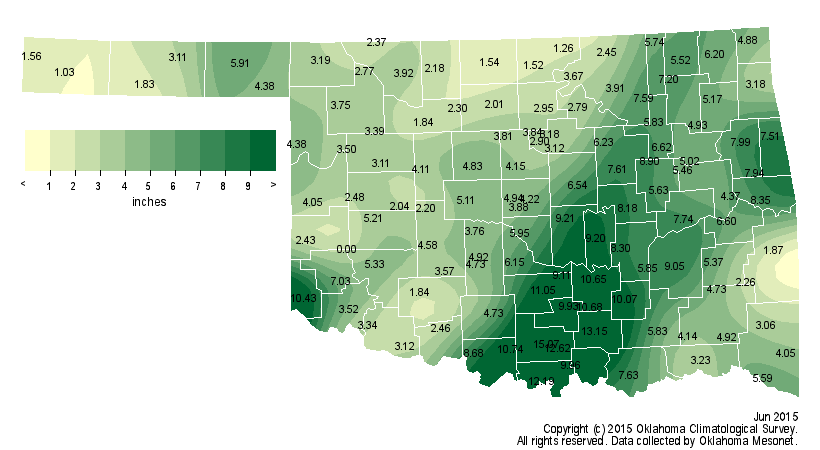
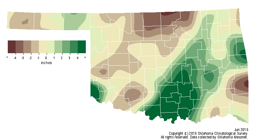
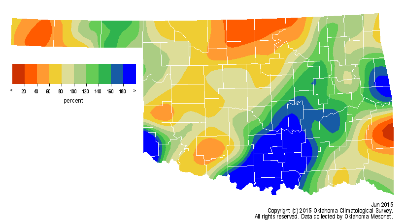
Thanks to the boost from the tropical systems, the statewide average
precipitation total as measured by the Oklahoma Mesonet was 5.04 inches, 0.52
inches above normal and the 33rd wettest June since records began in 1895. That
total would not accurately describe the precipitation pattern across the state,
however. South central Oklahoma had an average of 10.13 inches, 5.40 inches
above normal to rank as its third wettest June on record. In contrast, north
central Oklahoma received an average of 2.45 inches, over 2 inches below normal
to rank as the 31st driest. Newport led all Mesonet sites with 15.07 inches
while the Panhandle location of Boise City recorded the lowest total of 1.03
inches.
The National Weather Service (NWS) observing site at Ardmore recorded 16.83
inches for its wettest June on record, dating back to 1901. Healdton did the
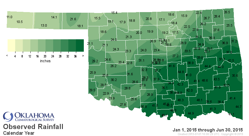
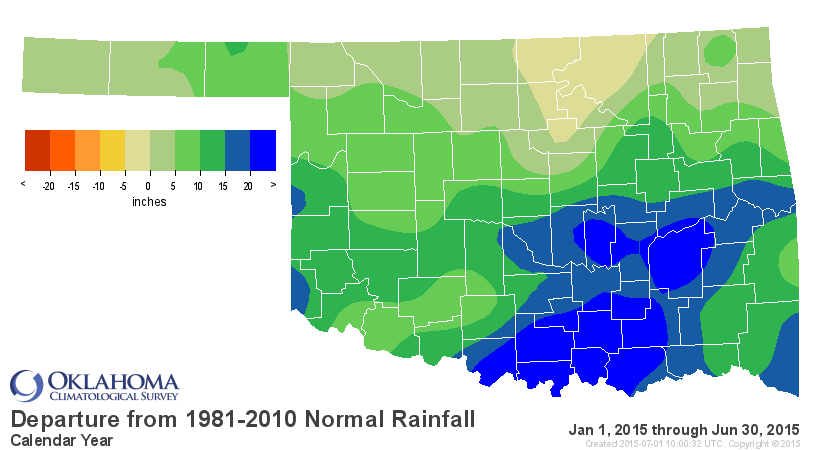
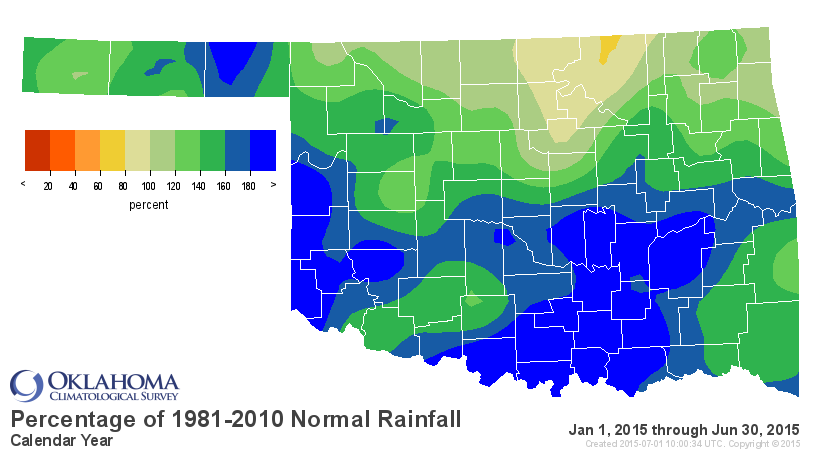
same with 15.48 inches dating back to 1894. The January-June statewide average
came in at 28.73 inches, nearly 10 inches above normal and the second wettest
first six months of the year on record. Only 1957's 32.69 inches stands higher.
For southwestern and south central Oklahoma, it was the wettest on record at
12.04 inches and 20.10 inches above normal, respectively.
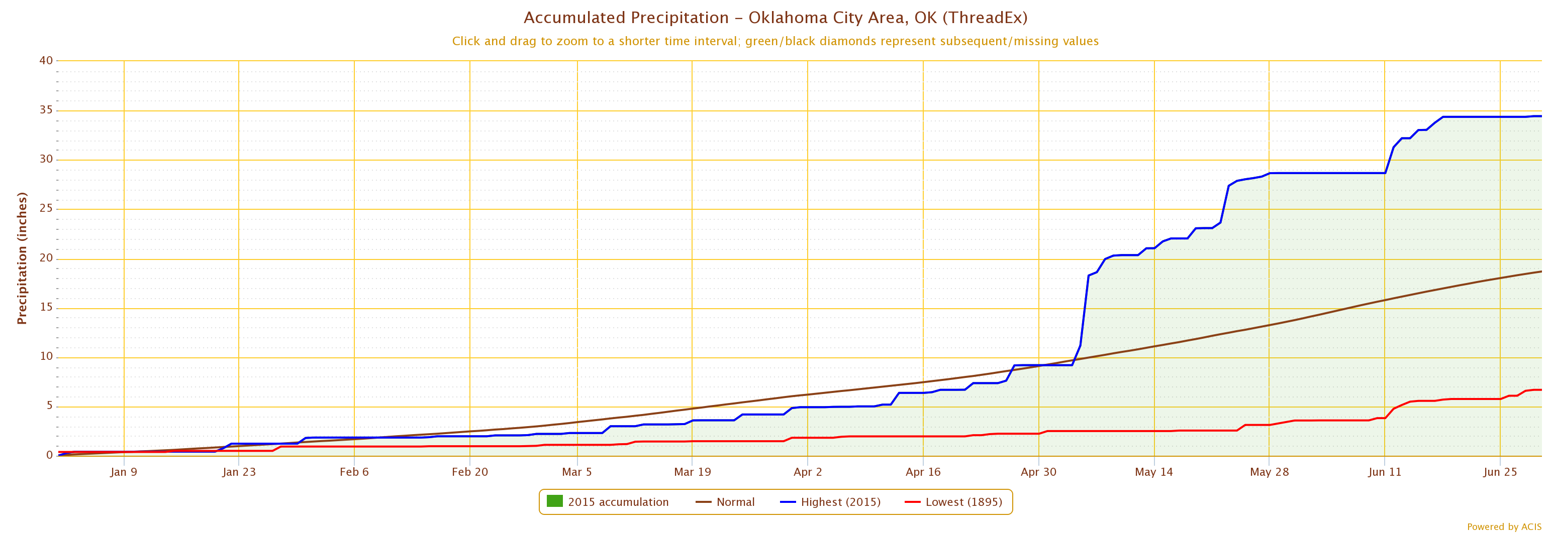
Oklahoma City recorded 5.77 inches during June to bring its January-June total
to 34.43 inches. That tops 1908's total of 33.23 inches as the wettest such
period on record.
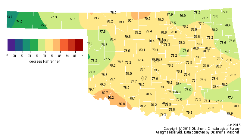
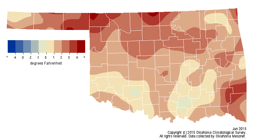
The statewide average temperature for June was 78.2 degrees, 1.7 degrees above
normal and ranked as the 33rd warmest June on record.
Altus and Grandfield reached 101 degrees on June 10 while Boise City matched
that high on the 22nd for the highest temperature of the month. Several
stations recorded 51 degrees on June 1 for the lowest reading. The January-June
statewide average stayed just below normal at 55.6 degrees, the 54th warmest
such period on record.
The number of confirmed tornadoes during 2015 stood at 75 through June
according to NWS data, although there were no reports during June. The total
for May rose to 67. The Mesonet site at Minco recorded a wind gust of 96 mph on
the 29th associated with a severe thunderstorm.
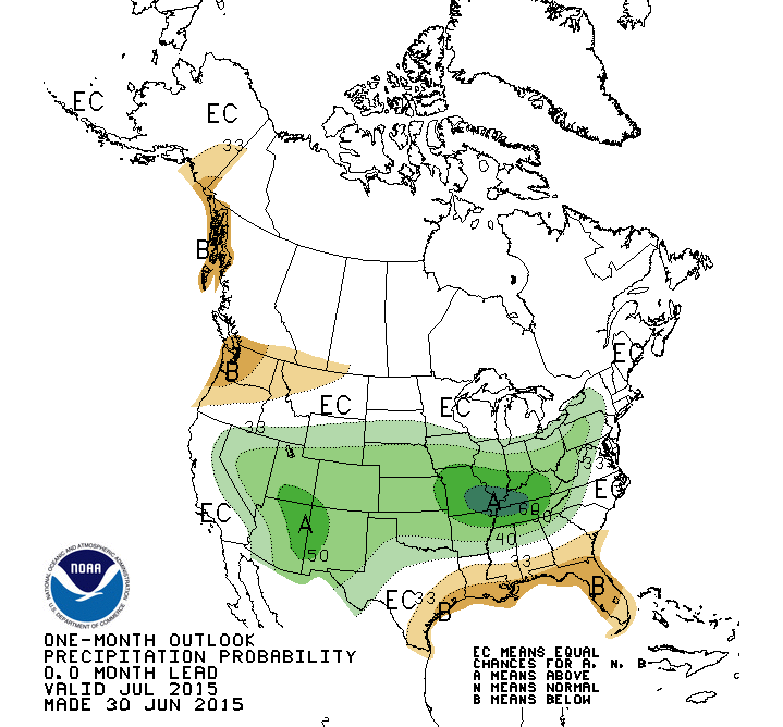
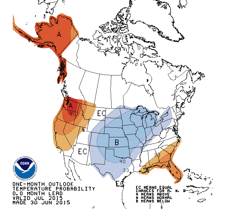
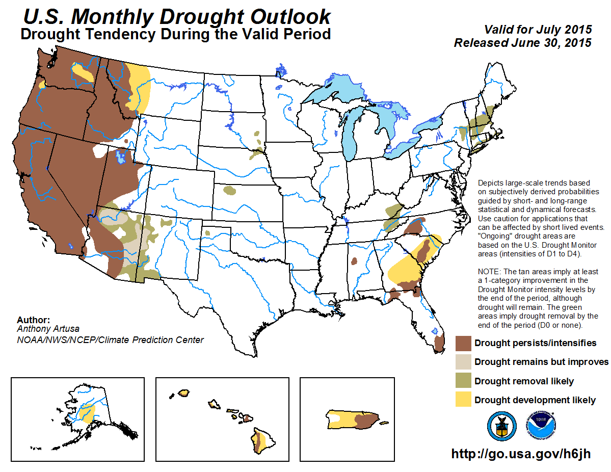
The July outlooks from the NWS' Climate Prediction Center indicate increased
odds of above normal precipitation and below normal temperatures. Accordingly,
CPC does not forecast any drought development in the state through the end of
July.
Gary McManus
State Climatologist
Oklahoma Mesonet
Oklahoma Climatological Survey
(405) 325-2253
gmcmanus@mesonet.org
July 1 in Mesonet History
| Record | Value | Station | Year |
|---|---|---|---|
| Maximum Temperature | 110°F | ALVA | 1997 |
| Minimum Temperature | 50°F | EVAX | 2017 |
| Maximum Rainfall | 5.82 inches | PAWN | 2016 |
Mesonet records begin in 1994.
Search by Date
If you're a bit off, don't worry, because just like horseshoes, “almost” counts on the Ticker website!