Ticker for May 24, 2015
MESONET TICKER ... MESONET TICKER ... MESONET TICKER ... MESONET TICKER ...
May 24, 2015 May 24, 2015 May 24, 2015 May 24, 2015
Simply put, the wettest month in Oklahoma history
And remember, it's raining as I type this, so forgive me if I go astray (it is
NOT raining like it's 1999, however...sorry, gratuitous Prince reference).
Obviously, with the ginormous rainfalls of the last couple of days, lot and lots
of records, especially at individual locations, were eradicated. But none bigger
than the wettest Oklahoma month on record. As of 1.15pm on Sunday, the statewide
average for May thus far stands at 12.29", 8.61" above normal and easily the
wettest May and month on record for Oklahoma. Let's look at the graphics and
also the leaderboard. These numbers are based on preliminary data from the
Oklahoma Mesonet.
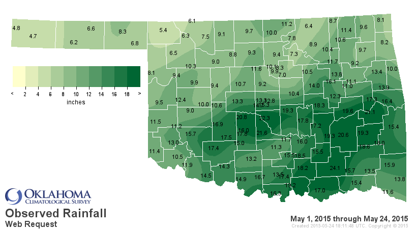
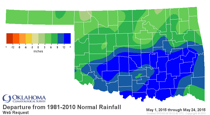
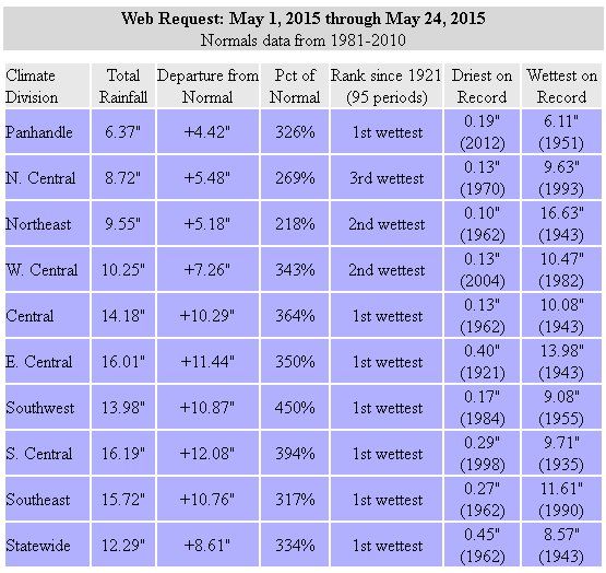
Highest All-Time monthly statewide rainfall averages
May 2015: 12.29"
Oct 1941: 10.75"
May 1957: 10.54"
May 1982: 10.38"
May 1943: 9.66"
Jun 2007: 9.51"
May 1902: 9.14"
Jul 1950: 9.07"
Those records date back to 1895. As we've talked about previously, the "official"
totals will be released by NCDC shortly after the end of the month, but the
Mesonet total is usually fairly close, and given that it will probably end up
beating the old record by a couple of inches, it's top spot is pretty well
assured.
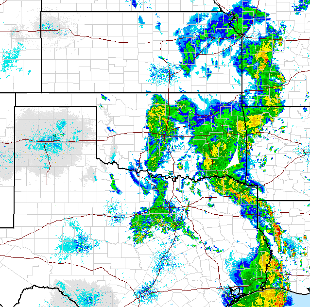
The catastrophic flash flooding yesterday was well predicted, and could
unfortunately continue into today as more rain continues to fall.
Obviously, many individual locations have broken either their all-time May or
"any month" records during this month thus far, with another week to go.
Oklahoma City has obliterated its record for wettest month after last night's
deluge, illustrated by NWS Norman's graphic on the subject.
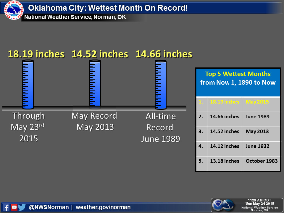
That graphic becomes dated with each drop of rain that falls today, but as with
the statewide graphic, we're not just beating those previous records, we're
obliterating them.
Here are the top-10 Mesonet totals through May 24 (some going up as we speak).
Lane: 24.08
Norman: 22.26
Washington: 21.64
Stigler: 21.11
Minco: 20.77
McAlester: 20.60
Eufaula: 19.63
Shawnee: 19.34
Stuart: 19.30
Madill: 19.23
Looking at non-Meosnet stations, the NWS COOP network is showing some high
totals as well:
BLANCHARD: 23.14
NORMAN: 21.96
LEHIGH: 21.91
ANADARKO: 20.39
SHAWNEE: 19.47
APACHE: 19.06
SEMINOLE: 18.24
It would appear that several of those totals may have broken the record for
highest May total precipitation at any location, previously held by Hennessey
with 22.38" back in 1957. There was also a reading of 27.08 inches from Bokchito
back in 2007, but it ended with a couple of missing days, so it makes me a bit
queasy to include it in the official totals. Same with Claremore's 22.44 inches
back in 2000. With further investigation needed, I'd say Hennessey held the
previous May record and therefore that mark of 22.38" from 1957 has been eclipsed
by several locations this May.
Could some of the totals shown above break the all-time wettest month for any
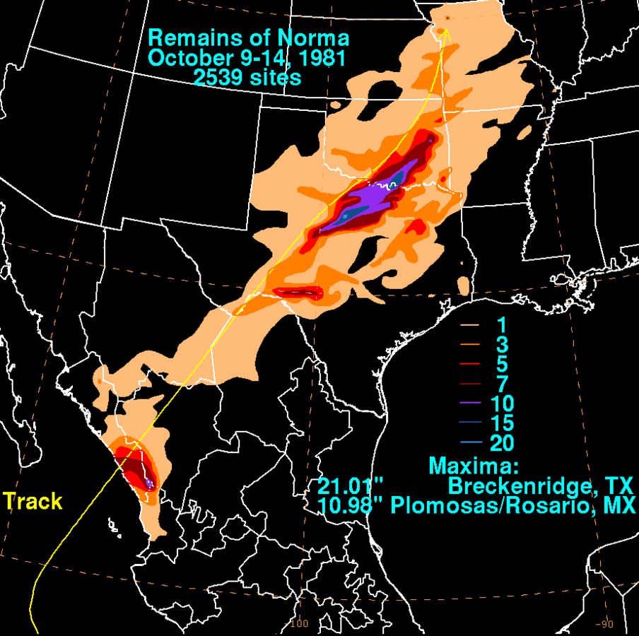
location, any month? That will take some digging. From what I can tell, Coalgate
holds the wettest month for any location in the state with a total of 28.12"
from October 1981, a month in which the remnants of Hurricane Norma turned the
eastern half of the state into the tropics for a bit. That same month, Madill
recorded a total of 25.80" and Kingston came in 3rd with a total of 24.69".
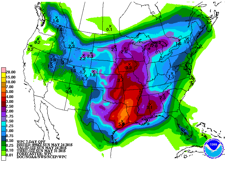
There is still a bit of rain to be had for the month of May, so the possibility
is there.
I hope you can appreciate the history we're seeing here. And when it comes to
history, the weather variety can often come with a lot of heartache and
unpleasantness. Nobody brags about the records for "most close to normal
rainfall" or "fewest days with abnormal temperatures." Nope, you're witnessing
history here, with all its warts and blemishes. Lots of bad news, but some good
news (i.e., drought eradication) to go along with it.
We're at the mercy of Mother Nature. Ain't it an interesting ride?
Gary McManus
State Climatologist
Oklahoma Mesonet
Oklahoma Climatological Survey
(405) 325-2253
gmcmanus@mesonet.org
May 24 in Mesonet History
| Record | Value | Station | Year |
|---|---|---|---|
| Maximum Temperature | 111°F | TIPT | 2000 |
| Minimum Temperature | 36°F | EVAX | 2017 |
| Maximum Rainfall | 6.54 inches | MCAL | 2015 |
Mesonet records begin in 1994.
Search by Date
If you're a bit off, don't worry, because just like horseshoes, “almost” counts on the Ticker website!