Ticker for May 19, 2015
MESONET TICKER ... MESONET TICKER ... MESONET TICKER ... MESONET TICKER ...
May 19, 2015 May 19, 2015 May 19, 2015 May 19, 2015
El Nino is angry, my friends
While I haven't actually been able to get any of our top ENSO (El Nino/Southern
Oscillation) experts to attribute this bounty of rain to the burgeoning warm
temperature anomalies in the equatorial pacific waters, which along with the
accompanying atmospheric coupling creates El Nino...they've come pretty darned
close. And I also don't believe it's a big coincidence that the May rainfall
records we are threatening occurred during big El Nino episodes (1957 and 1982).
As USDA climatologist Brad Rippey points out, 1957's El Nino ran from March-May
of 1957 through June-August of 1958. The El Nino of 1982 ran from April-June of
1982 through May-July of 1983. And let's not forget that 1957 was also the wettest
year on record with a statewide average of 47.88 inches. We still have a long
way to go with a year-to-date statewide average of 16.92 inches.
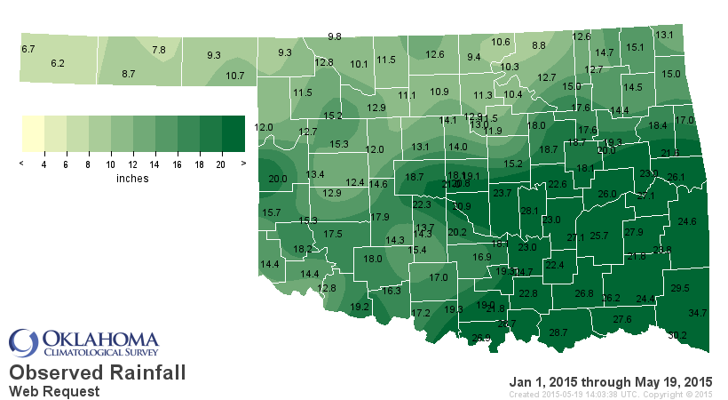
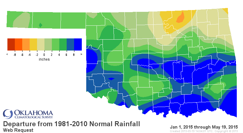
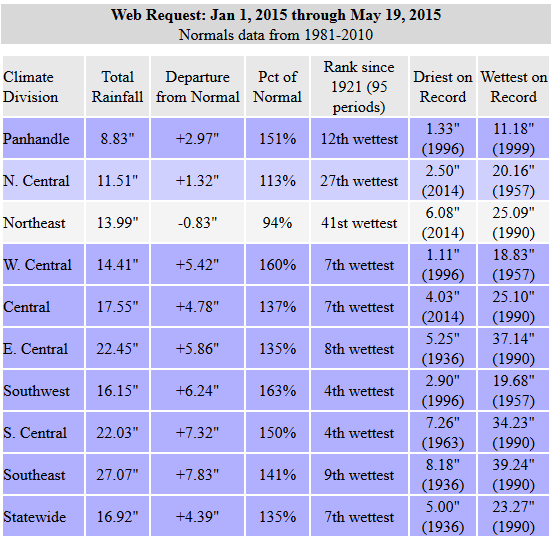
I don't believe we're going to eclipse that annual mark, but May 1957's 10.54
inches is definitely doable.
But heck, why stop there...why not go for the wettest month in state history...
October 1941's 10.75 inches? Is that doable? Well, check out the latest 7-day
rainfall forecast and you be the judge.
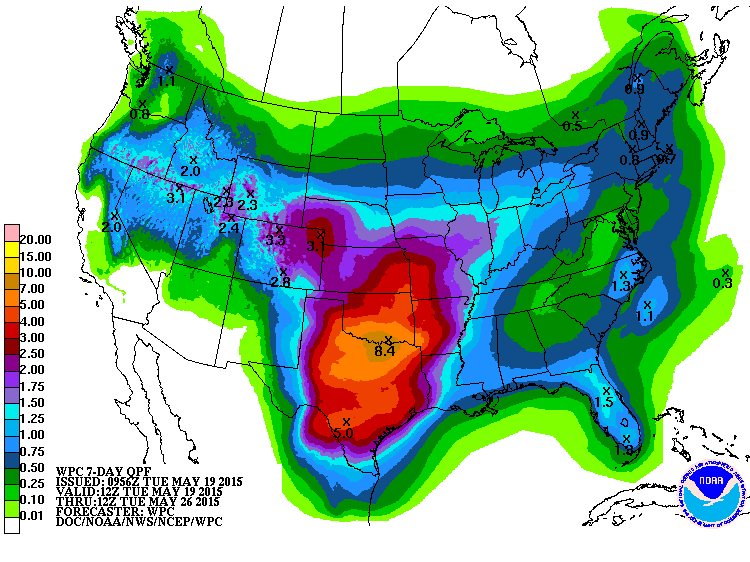
ZOUNDS but that's a lot of water! If that comes true, I don't know where we're
going to put it. And we're still seeing a wettish pattern for next week as well.
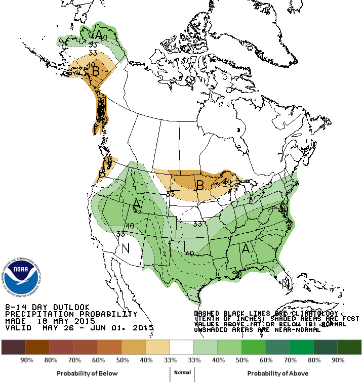
If this El Nino continues to build, and it does indeed strengthen into next
fall and winter, then I see more wet times ahead for the state, possibly erasing
even the long-term impacts of those half-empty reservoirs across western
Oklahoma. Although that could occur as early as this weekend if those gargantuan
rains really do arrive.
Here's a quote from Michelle L'Heureux of the NWS' Climate Prediction Center
(CPC). Michelle is one of the ENSO Monitoring and Prediction specialists at CPC.
"We have a nicely coupled El Nino event going on at the current moment.
It's rather respectable for this time of year and so you should feel
like you can make comparisons to the historical composite. As in
'the large-scale pattern of rainfall we're seeing over the south is
consistent with what we would expect from historical El Nino events'
plus or minus some features."
You can read more from Michelle and other ENSO experts on the "ENSO Blog":
http://www.climate.gov/news-features/department/8443/all
Here's another nugget from CPC's Stephen Baxter:
"Generally this is consistent with El Ni?o. There are statistically
significant positive precipitation and negative temperature footprints
during April/May, especially over West Texas and New Mexico. This does
extend northward toward Oklahoma. I do think it's worth noting that
this is not a weak ENSO event for the time of year. Just using Ni?o 3.4,
it it likely that the April-June season will be in the top 10% of
values going back to 1950. So in a linear sense, we would expect the
ENSO signature to be about as strong this (time of) year as it
could be."
A cautionary note from Michelle, once again reminding us that the attribution
of this rain to El Nino will require a bit more work later on down the road:
"Just keep in the back of your mind that it is not a strict
'attribution' per se...that requires a bit more heavy lifting."
And one more, from one of the world's top flood experts.
"We're gonna need a really big boat."
Maybe Noah was onto something?
Gary McManus
State Climatologist
Oklahoma Mesonet
Oklahoma Climatological Survey
(405) 325-2253
gmcmanus@mesonet.org
May 19 in Mesonet History
| Record | Value | Station | Year |
|---|---|---|---|
| Maximum Temperature | 107°F | ALTU | 2022 |
| Minimum Temperature | 32°F | KENT | 2019 |
| Maximum Rainfall | 5.33 inches | BOWL | 2017 |
Mesonet records begin in 1994.
Search by Date
If you're a bit off, don't worry, because just like horseshoes, “almost” counts on the Ticker website!