Ticker for April 6, 2015
MESONET TICKER ... MESONET TICKER ... MESONET TICKER ... MESONET TICKER ...
April 6, 2015 April 6, 2015 April 6, 2015 April 6, 2015
Be weather aware and whatnot this week
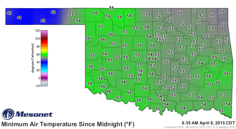
Before we get started with the hysteria, isn't it wonderful when your "cold start"
to the morning is in the 50s instead of the 20s or 30s? SPRING!
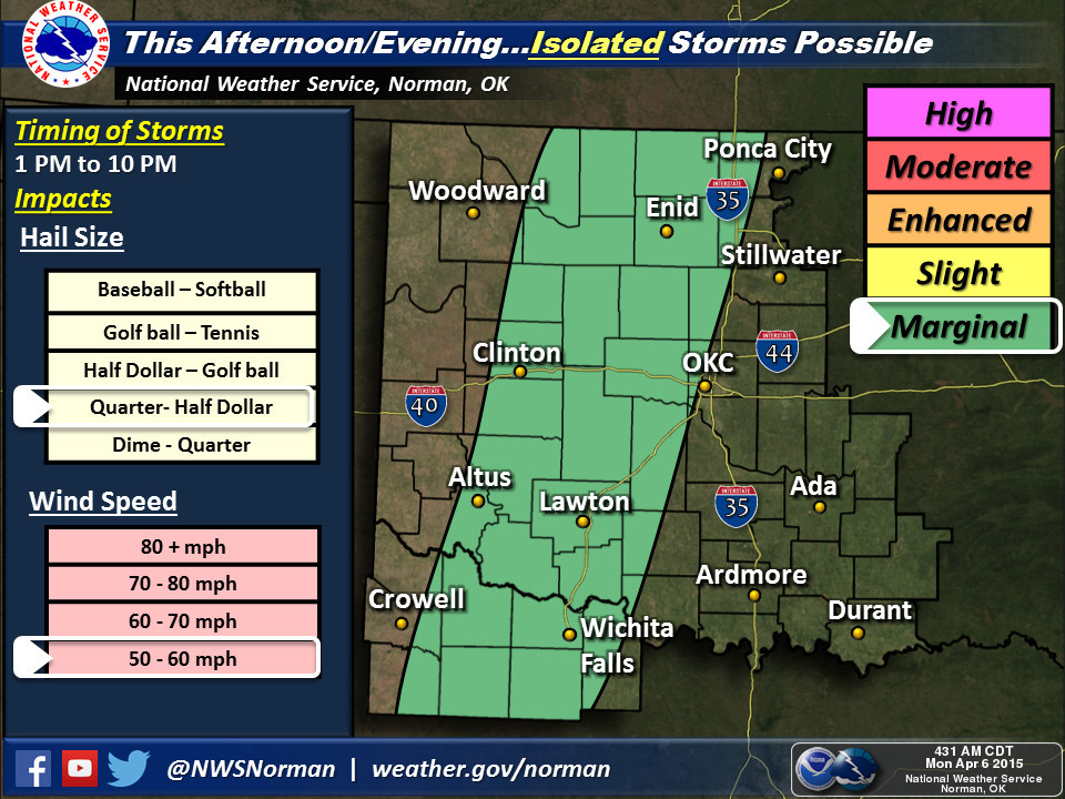
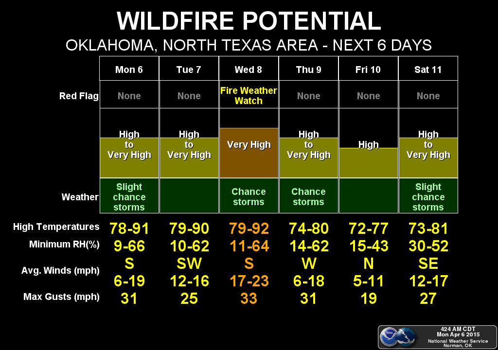
Unfortunately, the dryline is about to hit the fan starting today. Not much of
a chance for storms today
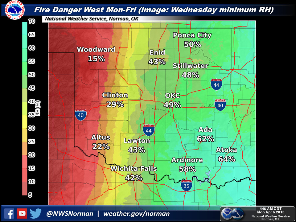
but the dry conditions (it IS called a dryline...hello, McFly!) out west along
with some strong winds and low humidity will create elevated fire danger
for the next several days, especially on Wednesday when the main brunt of the
current storm system moves in. Be on the lookout for a fire weather watch in the
west on Wednesday with possible svr-tstorms/tornado watches farther to the
east. Very April 2011-ish!
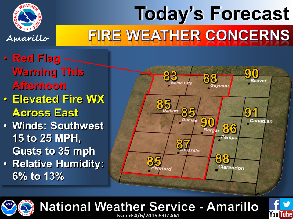
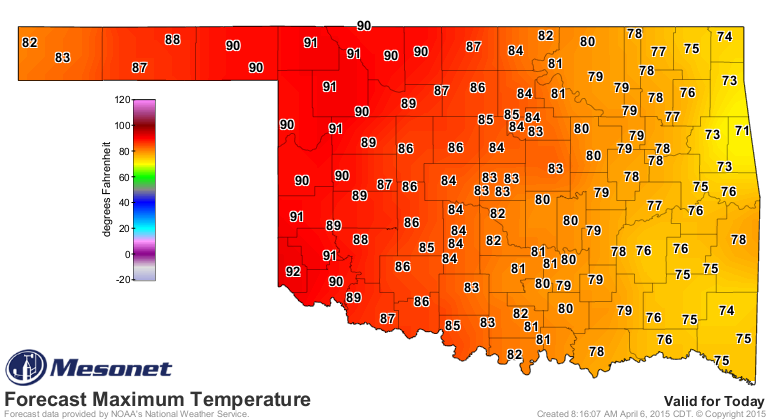
In the dry air out that way, it should get quite toasty today.
Then we turn to the possibility of severe weather, mainly for Wednesday and
Thursday, but there are slight chances for storms tonight and tomorrow as
well. As is often said, if anything can break through that capping layer of
warm air above the surface and go all storm on us, it is likely to become
severe. But again, this appears to be a Wednesday-Thursday scenario. There is
no promise of how much/bad/severe, etc., just yet. The storm system is just
coming onshore off the West Coast. But the Day Three Convective Outlook from
the Storm Prediction Center does give us this caution for the Southern Plains:
"EVENTUALLY...ASCENT SHOULD PROVE
SUFFICIENT TO ALLOW LOCAL BREACHES IN CAPPING -- AND RESULTING/RAPID
DEVELOPMENT OF ISOLATED STORMS. GIVEN A VERY UNSTABLE AIRMASS/STEEP
LAPSE RATES ALOFT...AND AIDED BY FAVORABLY STRENGTHENING/VEERING
FLOW WITH HEIGHT...STORMS SHOULD RAPIDLY BECOME SUPERCELLS. ALONG
WITH LOCALLY DAMAGING WINDS...VERY LARGE HAIL IS EXPECTED. IN
ADDITION...THE AMPLY MOIST BOUNDARY LAYER AND FAVORABLE LOW-LEVEL
SHEAR -- PARTICULARLY NWD INTO KS NEARER THE ADVANCING SURFACE LOW
-- WILL LIKELY BE SUFFICIENT TO SUPPORT RISK FOR TORNADOES. WHILE
OVERALL STORM COVERAGE SHOULD REMAIN WIDELY SCATTERED TO
ISOLATED...SIGNIFICANT SEVERE WEATHER IS EXPECTED WITH ANY STORM
WHICH DOES DEVELOP."
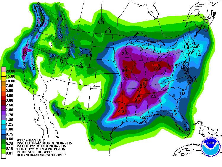
Right now the outlook is for a "slight" chance of severe wx, but be sure and
stay tuned to the SPC, your local NWS office, and your favorite media
forecaster over the next few days (and it looks like the coming weekend as well
as another storm system gears up for the area).
I mentioned this earlier, but this very much looks like the pattern we saw in
April 2011 where western Oklahoma ended up getting sand-blasted behind drylines
while central OK eastward had severe weather and some decent rains. Well, maybe
not QUITE as bad as 2011.
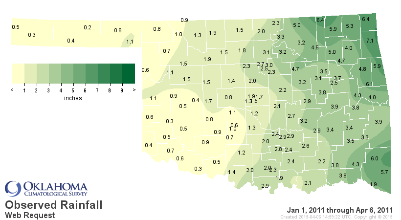
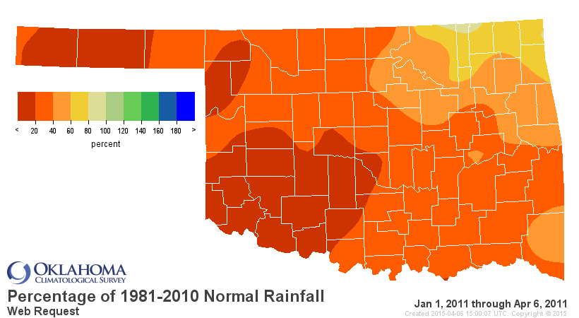
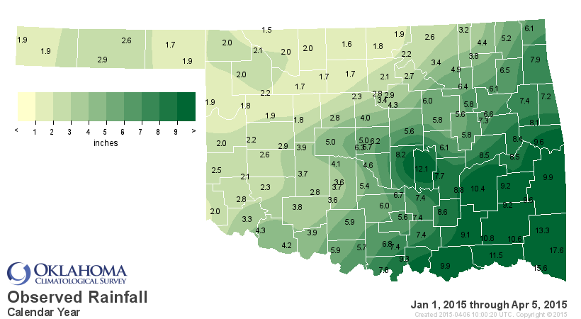
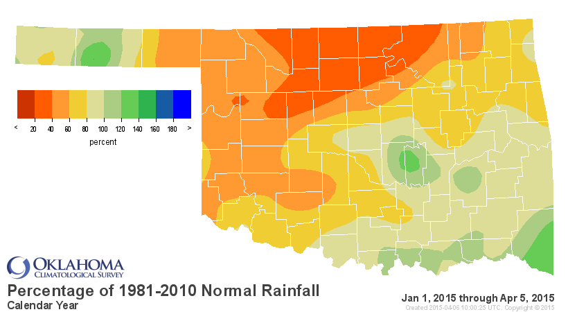
Nevertheless, not pretty this year. We want to avoid any comparisons to 2011...
one of the worst years of drought in OK history, as well as the second highest
tornado total since records began in 1950 with 119 (50 in April).
The dryline giveth, the dryline taketh away.
Gary McManus
State Climatologist
Oklahoma Mesonet
Oklahoma Climatological Survey
(405) 325-2253
gmcmanus@mesonet.org
April 6 in Mesonet History
| Record | Value | Station | Year |
|---|---|---|---|
| Maximum Temperature | 100°F | WALT | 2011 |
| Minimum Temperature | 14°F | EVAX | 2023 |
| Maximum Rainfall | 3.57″ | OKMU | 2018 |
Mesonet records begin in 1994.
Search by Date
If you're a bit off, don't worry, because just like horseshoes, “almost” counts on the Ticker website!