Ticker for April 1, 2015
MESONET TICKER ... MESONET TICKER ... MESONET TICKER ... MESONET TICKER ...
April 1, 2015 April 1, 2015 April 1, 2015 April 1, 2015
Bowlegs gets a drenching!

Yes, we also have the March summary below, filled with unfortunate news about
severe weather. Last night's severe stuff counts in that as well, and the Bowlegs
Mesonet site set the mood with nearly 6 inches of rain in about 6 hours.
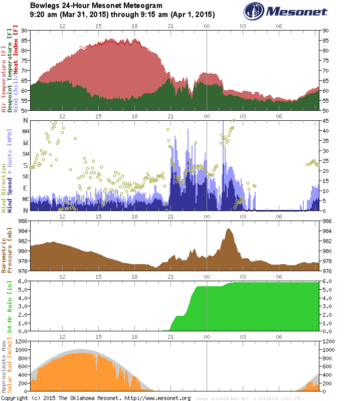
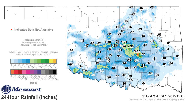
That's a pond full right there, but they weren't the only ones who got a good
gullywasher. A good 1-2 inches fell in a hurry from west of OKC down through
Seminole County (and Bowlegs). Some of those radar estimates from Seminole County
show 8+ inches of rain, possibly. Even SW OK got into the act with over an inch
in parts of Jackson and Tillman counties. It might not have been widespread, but
I'm sure they'll take it.
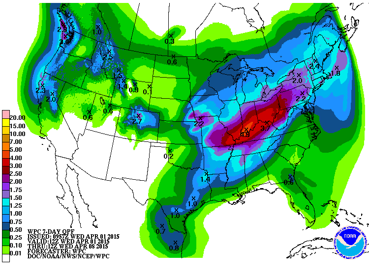
More is in the offing over the next week, but again,mostly across eastern
Oklahoma, supposedly.
There were also several reports of winds over 70-80 mph last night, so a bumpy
(AND LOUD) night indeed. As always, that generally comes along for the ride when
we get rain in the spring, so we take the good with the bad.
Speaking of bad, here is the summary of March weather as promised. Four weather-
related fatalities during the month make for an unfortunate headline.
-------------------------------------------------------------------------------
March Brings Severe Weather To Oklahoma
April 1, 2015
It took nearly the entire month, but severe weather finally made a rather
abrupt return to Oklahoma during the last week of March. Two separate storm
systems brought severe winds, large hail and tornadoes after a hiatus filled
mostly with winter weather headlines. On March 25, a combination of
thunderstorm winds and an intermittent tornado that reached EF-2 in strength
traveled through southwest Oklahoma City and Moore before dissipating in north
Norman.
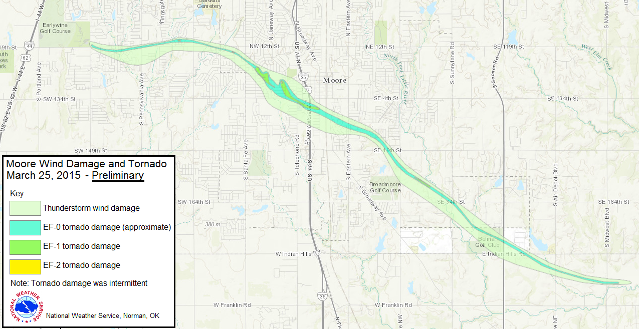
The twister caused significant damage to Southgate Elementary in central Moore
and the surrounding neighborhood. Seven injuries were reported with that storm.
The worst news came with another EF-2 twister that struck near Sand Springs
that same day, killing one resident and injuring 30 others. A weak EF-0 tornado
was confirmed to have touched down in northeast Tulsa, damaging homes and
businesses. The death near Sand Springs marks the first tornado related
fatality in Oklahoma since one person was killed near Quapaw on April 27, 2014.
Three other fatalities were attributed to the March 25 storms by the State
Medical Examiner. One person died in a single-vehicle traffic accident in
Norman and two others were drowned by flash flood waters as they were swept off
a bridge near Webbers Falls. Severe weather struck on the month's final day
with large hail, damaging winds of over 80 mph and flash flooding from
southwestern through east central Oklahoma. The Bowlegs Mesonet station in
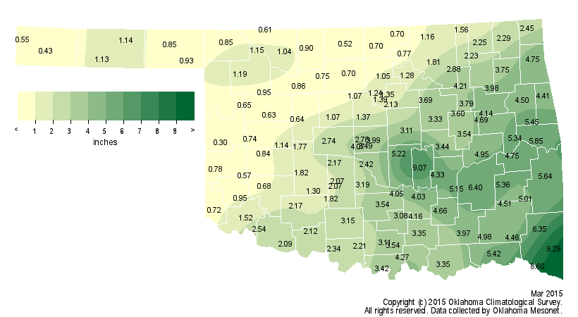
Seminole County reported 5.85 inches of rain in a 6-hour period. As mentioned
previously, winter weather had a hand in March weather as well. A blanket of
snow and sleet from 2-4 inches deep covered a good portion of the state on
March 4, closing schools and creating hazardous driving conditions.
Oklahoma's other weather disaster, the ongoing multi-year drought, continued to
intensify across western and northern Oklahoma, although some relief did occur
in the southeast. According to preliminary data from the Oklahoma Mesonet, the
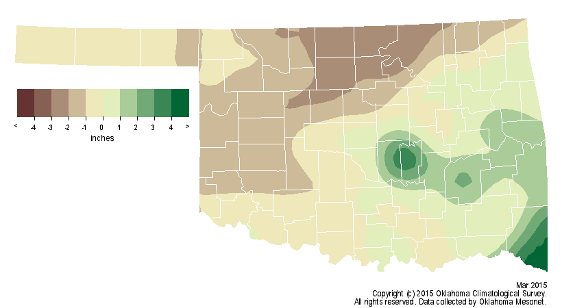
statewide average precipitation total was 2.63 inches, 0.41 inches below normal.
That does not give an accurate picture of the moisture fortunes for the
differing areas of the state, however. The southeast saw an average of nearly 6
inches, 1.45 inches above normal, to rank as the 17th wettest March on record
for that area. The west central and north central regions experienced deficits
greater than 1.5 inches each and ranked as the 33rd driest and 31st driest
March on record for those areas, respectively. Broken Bow led the state with
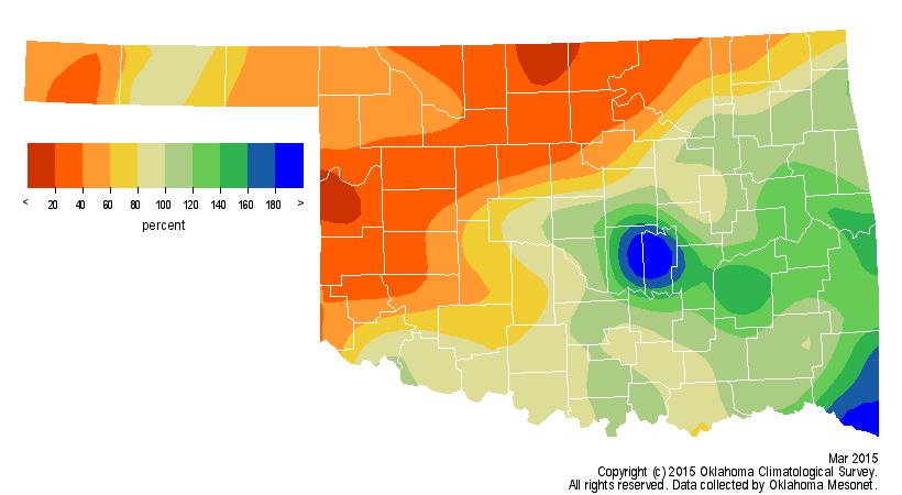
9.29 inches while Cheyenne only managed 0.3 inches for the month. Most of the
northwestern half of the state ended March with 60 percent to less than 20
percent of normal rainfall.
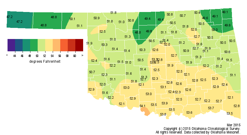
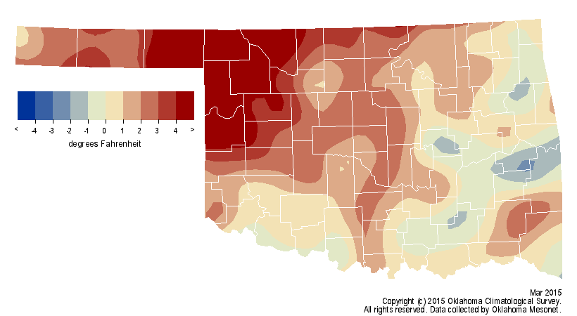
The statewide average temperature was 51.5 degrees, more than a degree above
normal to rank as the 41st warmest March on record. Hollis led all high
temperatures in the state with 92 degrees recorded on the 25th. Tipton and
Kingfisher reported the lowest readings at minus 1 degree on March 5.
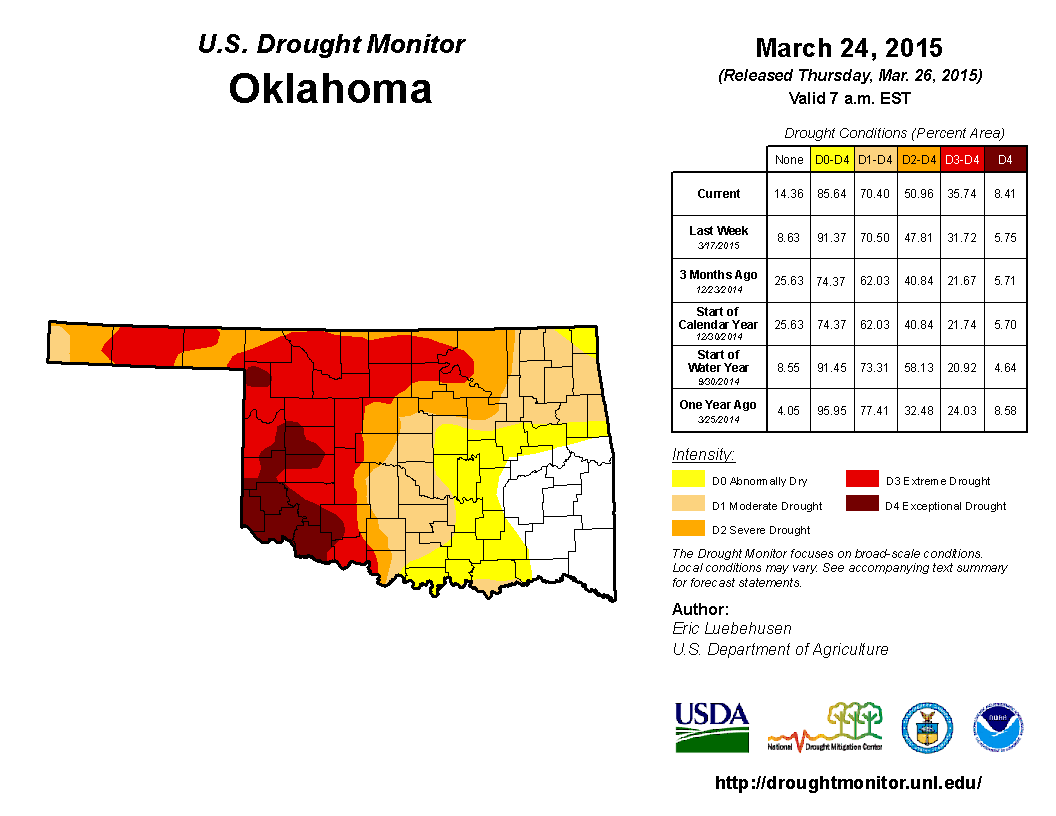
Even with the generous moisture totals in the southeast, the month's final U.S.
Drought Monitor report indicated nearly 51 percent of the state was in at least
severe drought and 36 percent in extreme-to-exceptional drought. Both
percentages are increases from February's final map. The Drought Monitor?s
intensity scale slides from moderate-severe-extreme-exceptional, with
exceptional being the worst classification.
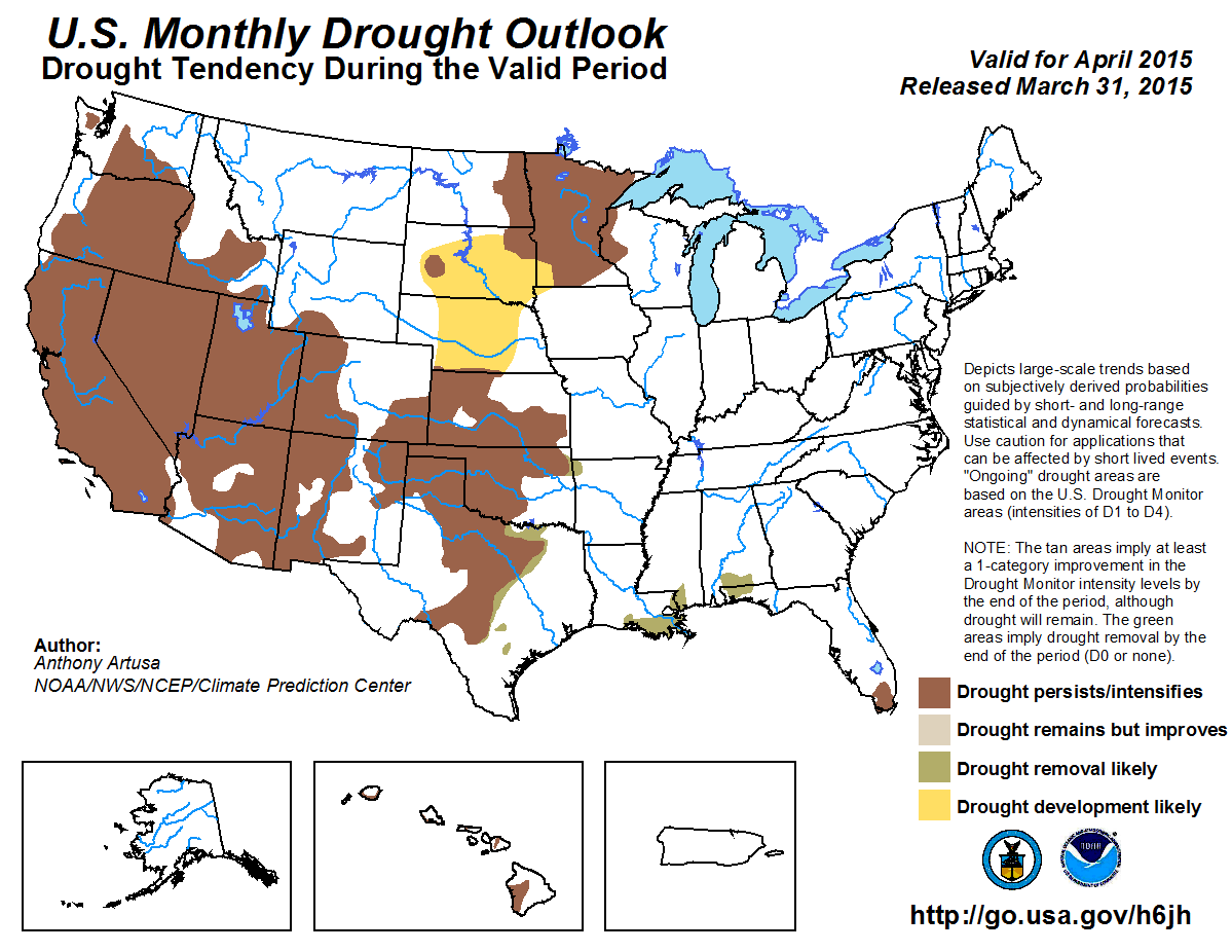
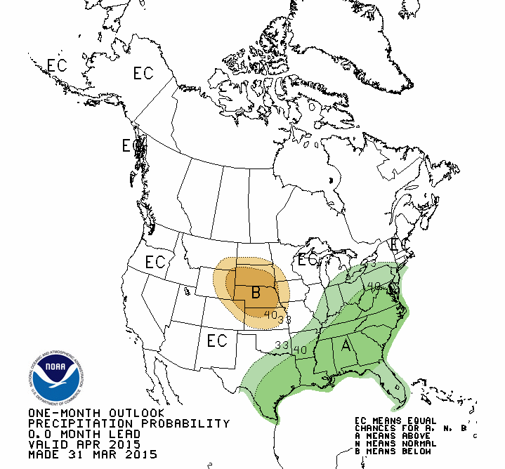
Prospects for April don't look promising according to the Climate Prediction
Center (CPC). Their Monthly Drought Outlook for April sees the drought either
persisting or intensifying across the state through the end of the month.
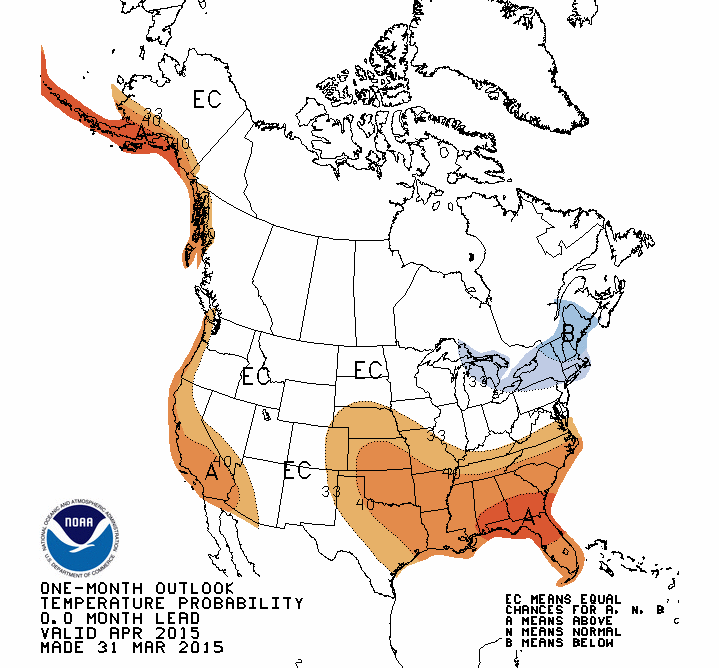
CPC's April temperature and precipitation outlooks call for an increased chance
of above normal temperatures across the entire state and slightly increased
odds for above normal precipitation over far southeast Oklahoma.
Gary McManus
State Climatologist
Oklahoma Mesonet
Oklahoma Climatological Survey
(405) 325-2253
gmcmanus@mesonet.org
April 1 in Mesonet History
| Record | Value | Station | Year |
|---|---|---|---|
| Maximum Temperature | 98°F | ALTU | 2012 |
| Minimum Temperature | 19°F | EVAX | 2023 |
| Maximum Rainfall | 2.57″ | TIPT | 2006 |
Mesonet records begin in 1994.
Search by Date
If you're a bit off, don't worry, because just like horseshoes, “almost” counts on the Ticker website!