Ticker for January 13, 2015
MESONET TICKER ... MESONET TICKER ... MESONET TICKER ... MESONET TICKER ...
January 13, 2015 January 13, 2015 January 13, 2015 January 13, 2015
El Limbo

It's been "promised" for more than 6 months now. The first "watch" went up last
March. We've seen odds from 50% all the way up to 80% through the fall, to no
avail. No, I'm not talking that miracle hair restoring powder I ordered off the
internet...I'm talking El Nino. As proof of the 10 months of waiting for it to
arrive, here's the first mention in the Ticker, hot off the presses at the time,
of an impending El Nino. And remember, many thought it would be of the "SUPER EL
NINO" variety from 1997-98, and it was going to cure all of our drought woes.
http://ticker.mesonet.org/select.php?mo=03&da=06&yr=2014
And it has looked pretty good at times. The sea surface temperatures have been in
at least the weak El Nino territory for some time. But as the latest CPC update
explained, the atmosphere, the other half of the El Nino equation, has just
never joined the team for the big win.
"Although the surface and sub-surface temperature anomalies were
consistent with El Ni?o, the overall atmospheric circulation
continued to show only limited coupling with the anomalously warm water.
The equatorial low-level winds were largely near average during
the month, while upper-level easterly anomalies continued in the
central and eastern tropical Pacific ... Overall, the combined
atmospheric and oceanic state remains ENSO-neutral."
So there you have it, we remain in ENSO-neutral conditions as opposed to El Nino
(or La Nina). Remember, ENSO, or the El Nino/Southern Oscillation, is composed
of El Nino, La Nina and Neutral conditions.
So the SSTs are on board, but the atmosphere is an important part of the puzzle,
especially when we consider the possible impacts on our part of the world. By
changing the SSTs in the equatorial pacific AND the air circulation patterns,
impacts are felt throughout other parts of the world through what are known as
"teleconnections." And that means just what it sounds like, the changes that can
occur at great distances from the area of the disturbed SSTs and air flow
patterns themselves. For example, here is the teleconnection-impact map for your
average, everyday El Nino (keeping in mind that they all have their own
idiosyncrasies and don't always follow the script.
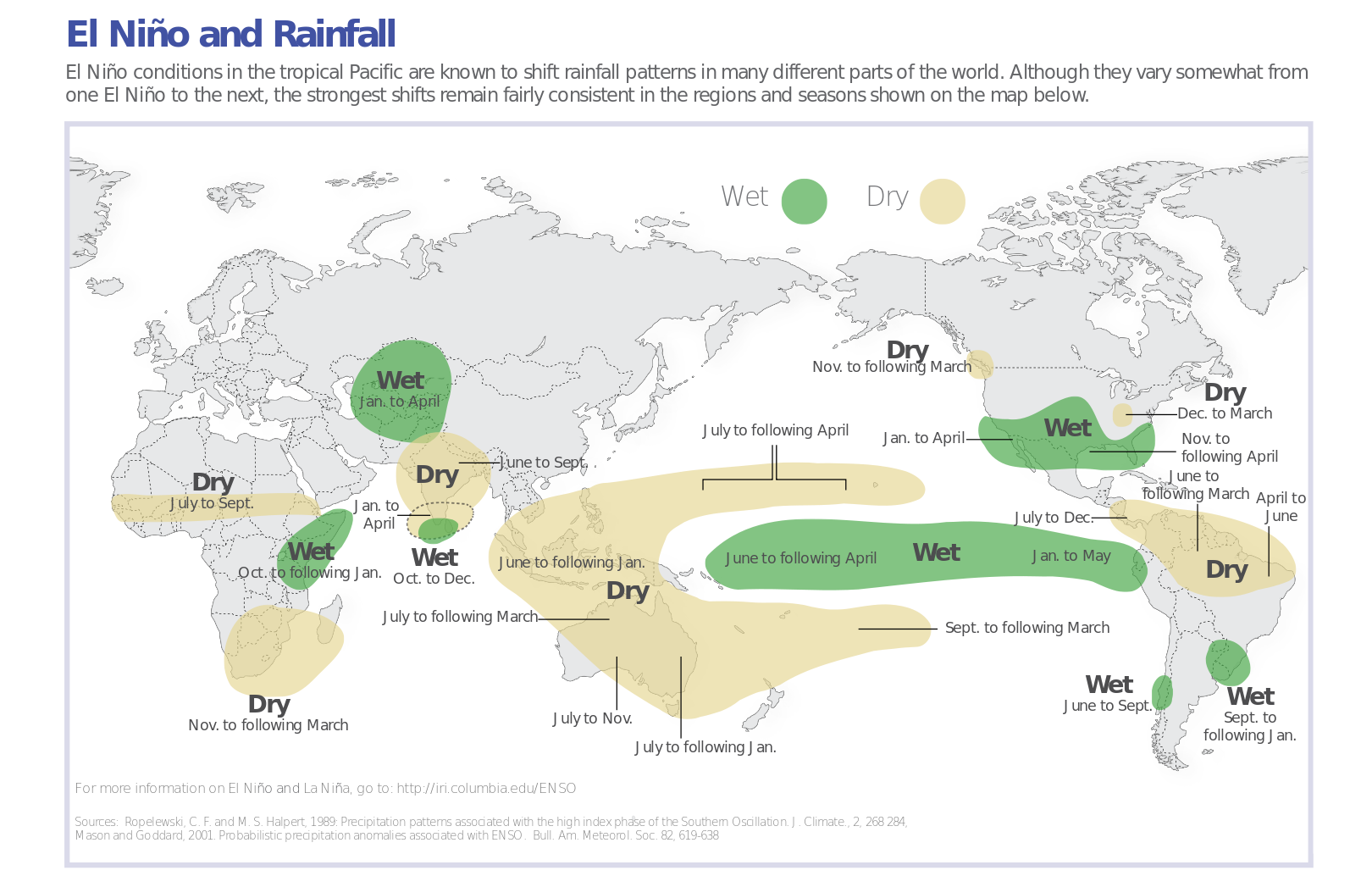
That shows our part of the Southern Plains seeing wetter than normal weather
for the November-April time period, at least more often than not during an
El Nino event. We've seen some impacts previously back into October as well,
so we differ just a bit with that map. But have we seen above normal rainfall
with this period of above normal SSTs, but no corresponding atmospheric
response? Well, not really. Here are the Nov. 1-Oct. 13 rainfall maps from
the Mesonet. You can see other than an area across SC OK associated with one
anomalous storm system, the majority of the state is decidedly dry.
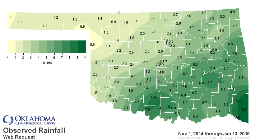
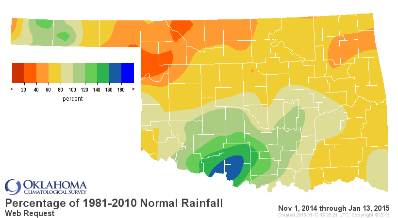
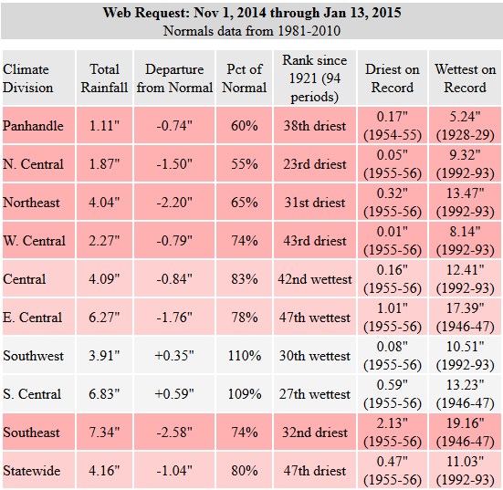
Certainly not the green statewide map we were hoping for, although those down
across SC OK will certainly sing the praises of that November storm. But that's
why you need that atmospheric component, to get that teleconnection working
through the atmosphere. No atmospheric changes to go along with the SST changes
and we can't realize any impacts to our weather. Another reason we need that
atmospheric response is so that it can create a feedback look with the ocean
so they can help sustain and intensify each other.
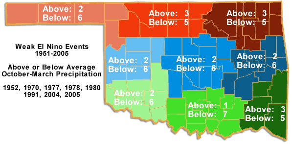
At any rate, we DO NO have El Nino yet, the time its impacts are felt is starting
to diminish with each passing day, and we've found a weak El Nino (which is what
this one would be if it ever did form) is not good for Oklahoma anyway.
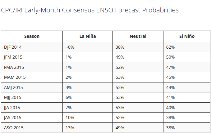
However, CPC is still going with a 50-60% chance of El Nino conditions occurring
during the next two months with ENSO-Neutral on tap after that. This table gives
the odds for each of the three-month periods starting with the current December-
February (DJF 2014) period. As you can see, El Nino has the highest odds for
the Dec-Feb and Jan-March periods, then ENSO-neutral conditions rise to the top
of the betting pool.
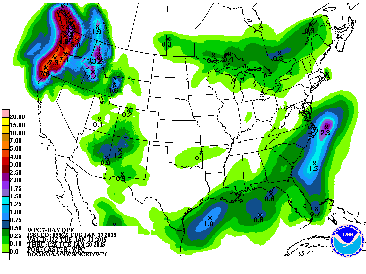
Oh by the way, chances for precip over the next 7 days? SPLAT!
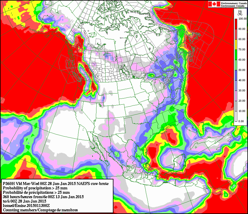
How about odds of seeing at least an inch accumulate through late January?
BZZZZZZZZTTTTTT!!
That could change in a hurry, of course. Stranger things have happened. Not with
mysterious powders ordered off the internet, however.
Gary McManus
State Climatologist
Oklahoma Mesonet
Oklahoma Climatological Survey
(405) 325-2253
gmcmanus@mesonet.org
January 13 in Mesonet History
| Record | Value | Station | Year |
|---|---|---|---|
| Maximum Temperature | 76°F | WAUR | 2022 |
| Minimum Temperature | -6°F | KENT | 2024 |
| Maximum Rainfall | 3.48 inches | WIST | 1995 |
Mesonet records begin in 1994.
Search by Date
If you're a bit off, don't worry, because just like horseshoes, “almost” counts on the Ticker website!