Ticker for July 28, 2014
MESONET TICKER ... MESONET TICKER ... MESONET TICKER ... MESONET TICKER ...
July 28, 2014 July 28, 2014 July 28, 2014 July 28, 2014
A July we're gonna remember! And a caution about El Nino.
As I sit and watch the radar light up this morning thanks to yet another July
cool front (that in itself is almost enough to make it memorable)
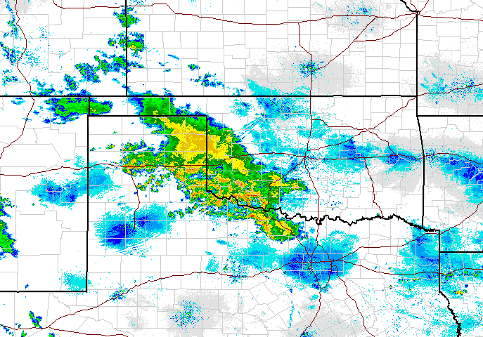
and I look at the huge rainfall amounts predicted through the end of the week

I think more and more that we are going to end up with a historic July. We've
already hit the historic note with the cool nature of the month, even though
we've been baking for a few days. The record cool weather of a couple weeks ago
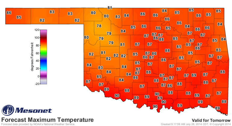
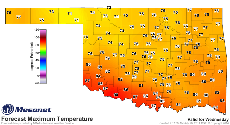
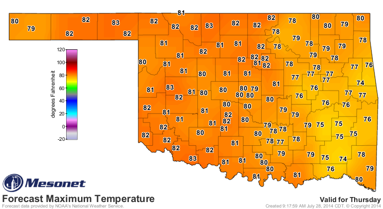
probably won't show up, but we'll be 10-15 degrees below normal throughout
much of the week. And remember, the end of July and the first few days of August
are historically the hottest time of the year in Oklahoma.
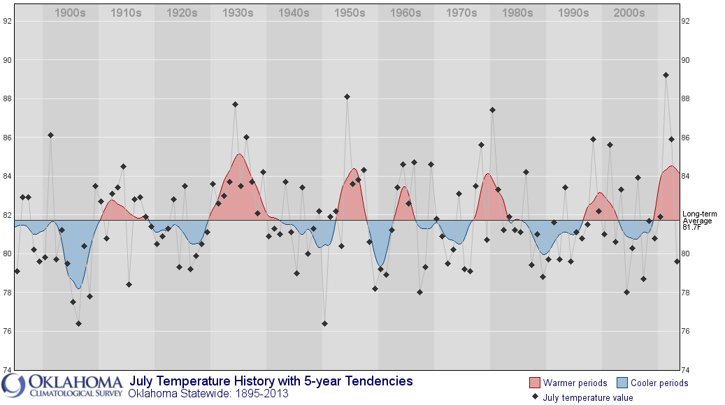
The statewide average temperature so far this month (through yesterday) have
been 3.6 degrees below normal at 77.8 degrees. The coolest July on record is
actually a tie at 76.5 degrees, occurring both in 1906 and 1950. And we have a
four more days of cooler than normal weather to drop that average. If we ended
July today, we'd be tied with 1908 for the fourth coolest July on record. While
all this data is still preliminary, there is an extremely good chance we
will end up as the coolest July we've seen in the state in over 60 years.
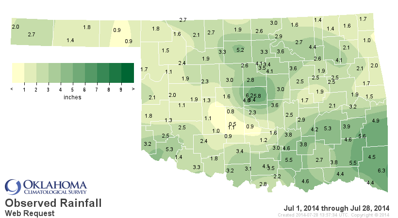
One the precipitation side, as we mentioned earlier, parts of the state have
seen great rains during the month. Statewide, however, we're barely above
normal at 2.71 inches, the 40th wettest July 1-28 since at least 1921. The
Southeast has seen its 21st wettest July 1-28, but the Panhandle has seen its
35th driest.
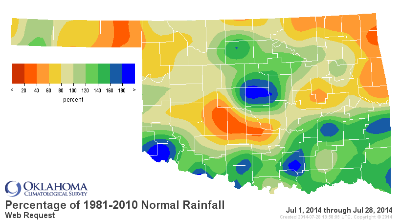
If the rains forecast for this week come to fruition, we can really zoom up the
rankings. And remember how I always say "the more it rains in the summer, the
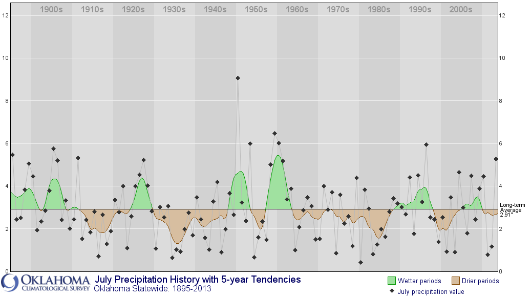
more mild that summer is?" Well, I do! And take a look at the historical July
rainfall figure. Which year had the most July rainfall? 1950 (tied for coolest
on record)! By the way, I think 1950's precip record of 9.07 inches statewide
is probably safe (or we're gonna need a lot of lifeboats in the next few days).
-------------------------------------------------------------------------------
Now before I sign off, let's talk a bit about El Nino (or in this case,
El NoNo). I've had a few e-mails and a couple of calls this morning asking if
El Nino is here, and is it the cause of our memorable weather over the last
couple of months. The answer is an emphatic "NO!" And here's why.
1. El Nino has not even developed yet. In fact, the specific region where
tropical weather experts determine the state of ENSO (El Nino/Southern Oscillation,
which contains El Nino, La Nina and Neutral conditions), is back into negative
territory with an anomaly of -0.1C. Anything above +0.5C is considered an El
Nino territory. However, to be a full-fledged El Nino (or La Nina), the
temperature anomaly must be above +0.5C for at least FIVE consecutive
overlapping 3-month seasons. Now if it goes above +0.5C for a month (again,
talking about the Nino 3.4 region of the equatorial pacific), then we have
what's called "El Nino conditions." But again, not a full El Nino. There are
actually a couple of other conditions to simply declare "El Nino conditions:
1.Departures in the Ni?o-3.4 index equal to or exceeding +0.5C for a single
month.
2. The tropical Pacific atmosphere should be consistent with El Ni?o. In
particular, rainfall should be enhanced near the Date Line and suppressed
near Indonesia, and the surface winds across parts of the equatorial Pacific
should be anomalously westerly.
3. A forecast that the index will equal or exceed +0.5C for several seasons in
a row.
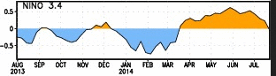
You can see from the chart below that the region did reach above +0.5C briefly,
but El Nino has not developed, at least yet. The highest it reached was +0.6C
on June 4, but even if that persisted, it would be an extremely weak El Nino
(and probably spell bad news for us).
2. The atmospheric portion of El Nino (the weakening of the low-level surface
winds that normally blow from east to west along the equator, or even a switch-
over from east-to-west to west-to-east) that help drive the warming of the
waters off the west coast of South America just isn't happening yet.
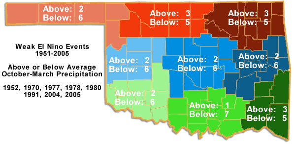
3. ENSO doesn't impact us during the warm season. It's generally a cool season
phenomenon for us. We're talking "October-ish" through "March-ish."
4. Not all El Ninos (and the same goes for La Nina) act the same way. The
impacts are generally felt more to out south. A strong El Nino (+1.5C and
above) can really give us some great moisture during the cool season, but a
weak one (+0.5 to +1.0) can be bad news.

5. More than a few tropical weather experts are starting to have negative
thoughts about the possibility of the promised El Nino that was to develop
late this summer into fall. The subsurface support for El Nino development has
faded away. As one tropical weather type said last week, "we may have to do a
postmortem on this El Nino!"
It will be very interesting to see the developments over the next few weeks
across the equatorial pacific, and CPC's monthly ENSO update early next week.
Stay tuned.
So when you start hearing "El Nino" being discussed, be sure and remember
these few tidbits. It has yet to form, it's impact on Oklahoma can be good OR
bad -- depending on the strength, and it's something we'd notice when we're
thinking of ghosts and goblins, turkey, Christmas trees, kisses at midnight,
red hearts, and the NCAA basketball tournament.
And I hope this doesn't all sound like "gibber-ish."
Gary McManus
State Climatologist
Oklahoma Mesonet
Oklahoma Climatological Survey
(405) 325-2253
gmcmanus@mesonet.org
July 28 in Mesonet History
| Record | Value | Station | Year |
|---|---|---|---|
| Maximum Temperature | 109°F | GRA2 | 2008 |
| Minimum Temperature | 47°F | MANG | 2005 |
| Maximum Rainfall | 3.50 inches | ALV2 | 2002 |
Mesonet records begin in 1994.
Search by Date
If you're a bit off, don't worry, because just like horseshoes, “almost” counts on the Ticker website!