Ticker for June 9, 2014
MESONET TICKER ... MESONET TICKER ... MESONET TICKER ... MESONET TICKER ...
June 9, 2014 June 9, 2014 June 9, 2014 June 9, 2014
How do you like me now...
now that I'm on my way? Do you still think I'm crazy ... okay, sidetracked by
Toby Keith (and we all know just how painful that can be). But this is almost
unheard of. Me, Gary McManus, the Drought Whisperer, the Ayatollah of Drought and,
uhhhhhhh, Dustola(?), talking rain for the umpteenth Ticker in a row? Yes! It
has rained, A LOT, since we last Ticked. This time around, southern Oklahoma
finally got theirs as well, an important note since that was the newest area
of serious drought intensification. How much has it rained? The Mesonet maps
tell the total. We'll just go back 7 days to be sure and grab all the totals.
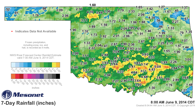
Just look for the yellers and oranges for the highest totals. You can see
that areas south of I-40 and also parts of far northwestern Oklahoma (including
a blob over an innocent little pond south of Buffalo in Harper County ... can't
wait to check it out next time I'm back that way) received from 4 inches to
some radar estimated values between 6-8 inches. Now some areas didn't get much
(what's up, Vinita??), but those areas are fewer and much more far between.
Heck, just for June itself we've had a statewide average of about 3 inches,
which is only about 1.75 inches below the normal total for the entire month ...
and it's only June 9th! But remember, this all started with that slow-moving/
cutoff upper-level low pressure system back on May 21 with a few showers out in
Beaver County. Then after a short hiatus, we had this stalled frontal system
providing the focus for shower. So other than a bit of a break in late May and
early June between systems, it's rained (and rained well) somewhere in the
state almost everyday since. Let's check out those Mesonet rainfall maps and
the statistics table since that rather innocuous beginning back on May 21.

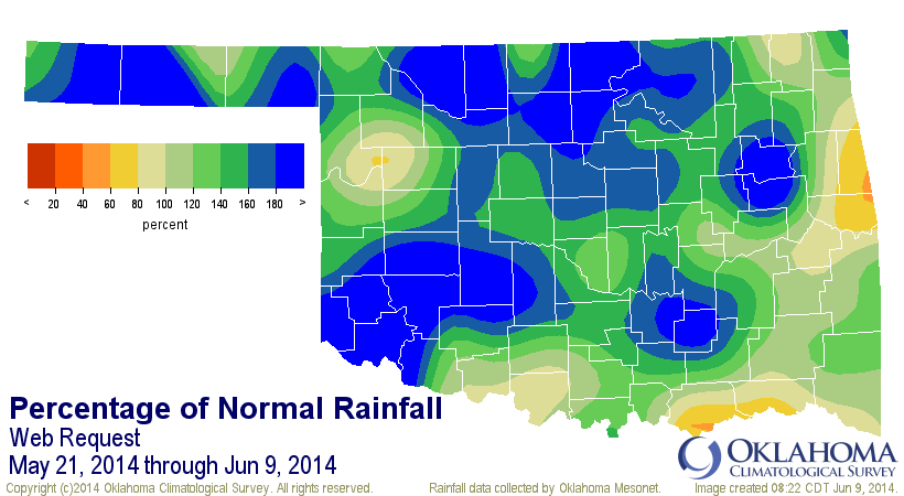
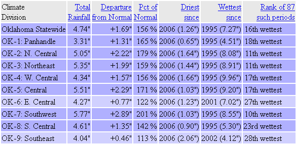
I'll just let you know that when you are experiencing your 16th wettest May 21
through June 9, at least back to 1921, you are seeing some serious moisture.
Mid-May through mid-June is normally the wettest time of the year for most
of the state, so 156% of normal through that period is significant.
Here are some of the individual Mesonet rainfall totals through that period (May
21-June 9).
-***-
Porter 10.02" Burbank 6.99" Spencer 6.37"
Blackwell 8.28" Apache 6.85" Minco 6.35"
Lake Carl Blackwell 7.95" OKC West 6.81" Pauls Valley 6.28"
Hobart 7.91" Bristow 6.78" Cherokee 6.27"
Haskell 7.69" Tipton 6.64" Ada 6.18"
Wynona 7.54" Breckinridge 6.59" Retrop 6.05"
Bowlegs 7.36" Perkins 6.59" Stuart 6.04"
Acme 7.14" Fittstown 6.54" Washington 6.03"
Altus 7.10" Mangum 6.54"
Fort Cobb 7.04" Centrahoma 6.41"
-****-
There are still some have-nots through that period, but I'll keep them under
wraps lest they feel bad (although the lowest total belongs to a town that
rhymes with "Shamarargo" with a measly 2.04 inches).
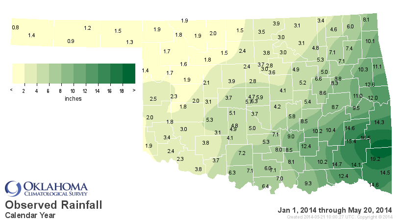
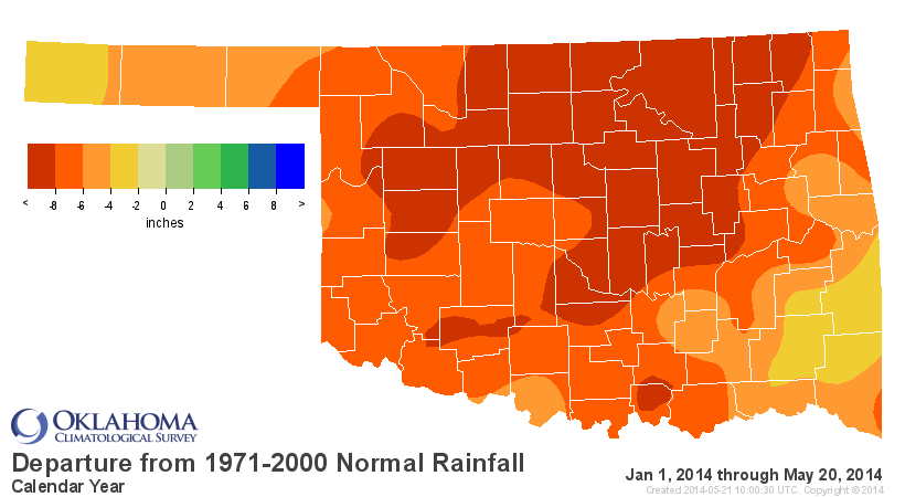
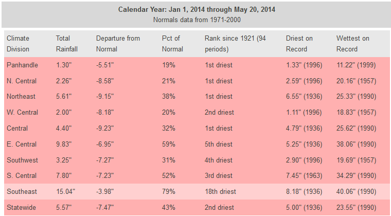
The reason this rain is so important has been Ticked about to death, but let's
go back and revisit the January 1-May 20 rainfall train wreck to remember why
we should be so thankful for the last three weeks.

Now the better news is IT IS STILL RAINING!

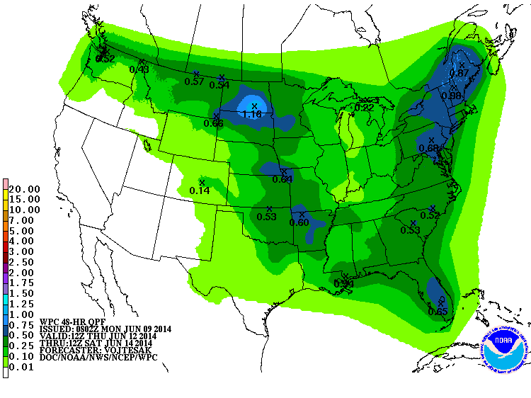
And apparently there are still more rains possible in the forecast.

When looking at these 7-day forecast amounts, keep in mind some of it was
destined to fall this morning.
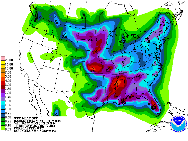
This is what is expected to fall from Thursday morning through Saturday morning:
We will still have to wait a bit to see the impacts on area lakes, at least
the ones across western Oklahoma and a few select lakes in other areas, like
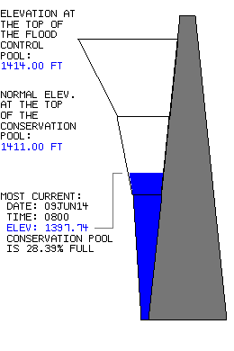
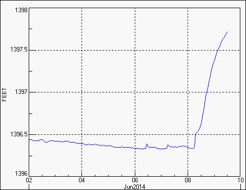
Texoma and Skiatook. As a preview, however, Tom Steed Lake, Altus' main
drinking supply that had hovered close to 20% of capacity for the last few
months, is now up to 28% and still filling!
Remember, drought relief is a process, just like drought intensification. That
first set of rains in May moistened the soils, now the rain that falls can
become runoff into the lake. And it matters where it falls in the watershed,
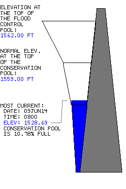
of course. Nearby Lake Altus-Lugert, a major cotton irrigation lake in the
area, has not fared quite so well and remained down around 11% capacity, at
least so far.
So we'll do a re-evaluation of the lakes later this week when all the runoff
from streams has a chance to get where it's going.
All this spells more drought relief for the state with a great chance now to
have a bit more pleasurable summer. For instance, when's the last time you've
heard about fire danger? A green state in June is normally a much happier state
in August. Looked a bit scary there for awhile, but everything's coming up
roses now. Unless you planted begonias, of course.
Gary McManus
State Climatologist
Oklahoma Mesonet
Oklahoma Climatological Survey
(405) 325-2253
gmcmanus@mesonet.org
June 9 in Mesonet History
| Record | Value | Station | Year |
|---|---|---|---|
| Maximum Temperature | 104°F | ALTU | 2011 |
| Minimum Temperature | 43°F | EVAX | 2020 |
| Maximum Rainfall | 5.12 inches | BOWL | 2008 |
Mesonet records begin in 1994.
Search by Date
If you're a bit off, don't worry, because just like horseshoes, “almost” counts on the Ticker website!