Ticker for October 24, 2013
MESONET TICKER ... MESONET TICKER ... MESONET TICKER ... MESONET TICKER ...
October 24, 2013 October 24, 2013 October 24, 2013 October 24, 2013
A whole lotta white!
The newest U.S. Drought Monitor finally caught up on all the rainfall and the
drought impacts that were improved due to that rainfall. Now we are left about
where we were after June as we got into mid-summer with most of central, north
central, northeast and east central Oklahoma out of any sort of drought/dry
designation.
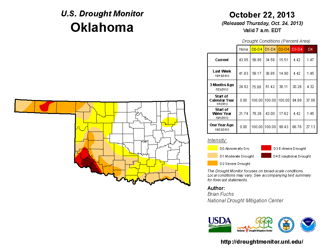
That means we have 43% of the state without any color on the drought map, and we're
therefore down to about 57% of the state still in D0-Abnormally Dry to D4-Exceptional
drought. And not a shock that most of the worst conditions are confined to the
northwest in the Panhandle and also down to the southeast.
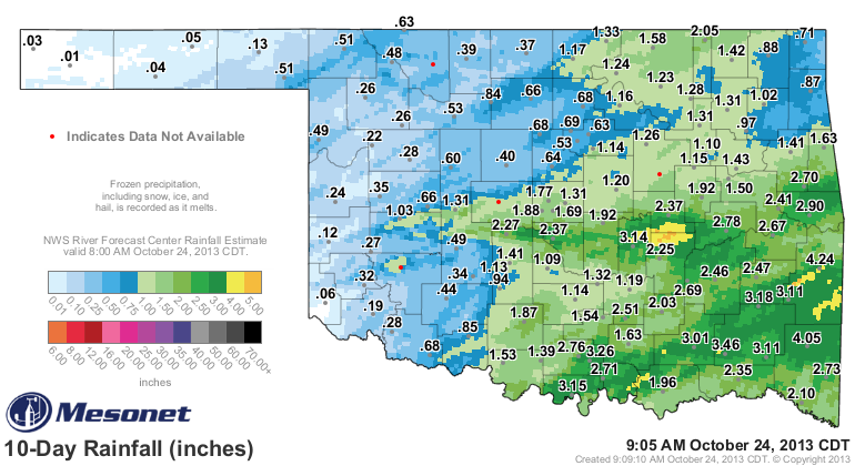
The latest improvements are due to that rainfall of more than a week ago now, but
it had come after the 7am Tuesday morning cutoff point for last week's map. That's
why we see improvements on this week's map despite any significant rainfall this
week (although central Oklahoma saw a nice line of an inch or more, but that was
in areas without drought already). However, we can still see last week's rain
on the 10-day rainfall total map from the Mesonet.
The reason drought hasn't gone completely away down in the southern reaches of
the state are evident when you look at the longer-term rainfall maps. And again,
I go back to that magical Aug. 17 date when the great summer rains we were seeing
shut off and flash drought materialized across the area.
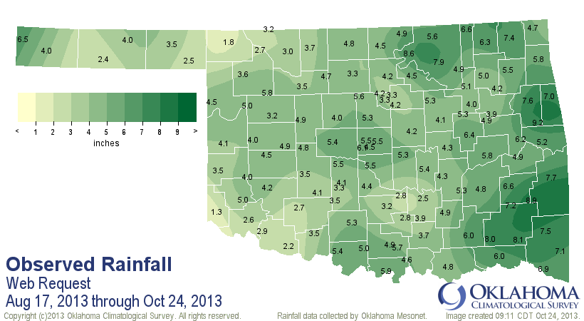
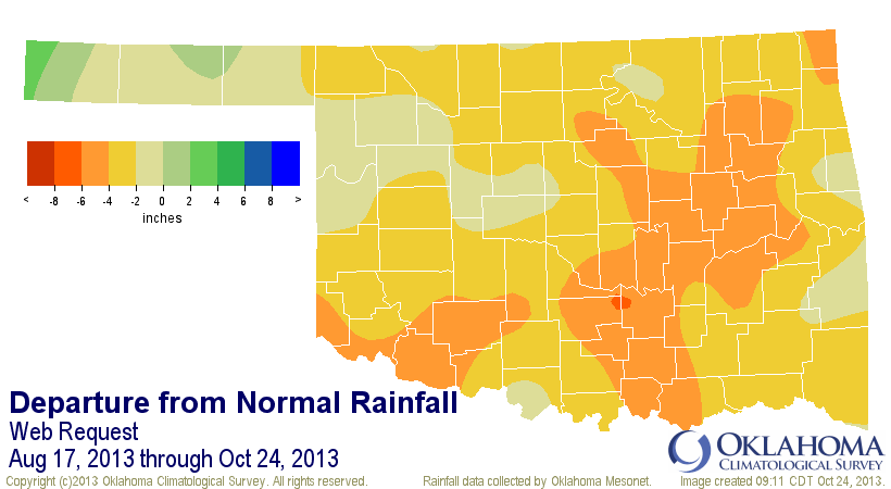
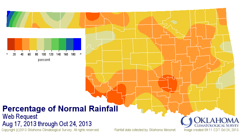
So the drought map continues to be a balancing act between recent rains and
the improvements those have brought versus the long-term dryness that not only
goes back to Aug. 17, but back to more than three years ago when the drought
really got its start in October 2010.
The soil moisture data from the Mesonet down to 24 inches shows where some of
the longer-term impacts that I speak of, with dry soils across the southwest,
northwest, and even up into north central Oklahoma. When we see things such
as that, we start hoping for more rainfall. Luckily, it appears we might have
a pretty wet system headed this way next week. Now it might disrupt the trick-
or-treat crowd, but that's okay because we need that moisture in several areas.
This 7-day rainfall total forecast is good through Halloween morning, so it has
a chance to change as we go forward.
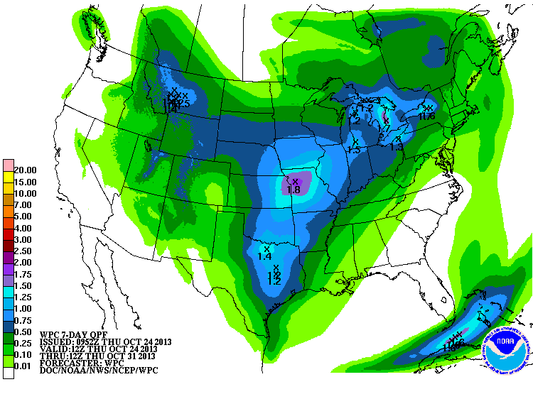
The trouble with forecasting this system is that it is not even onshore up in
the Pacific Northwest yet, so all bets are off for now. And even then things are
iffy since it could become a cutoff-low (and those are fairly difficult to pin
down once they form). Some of that rain could come this weekend as well. Here
are some graphics from the local NWS offices depicting upcoming changes.
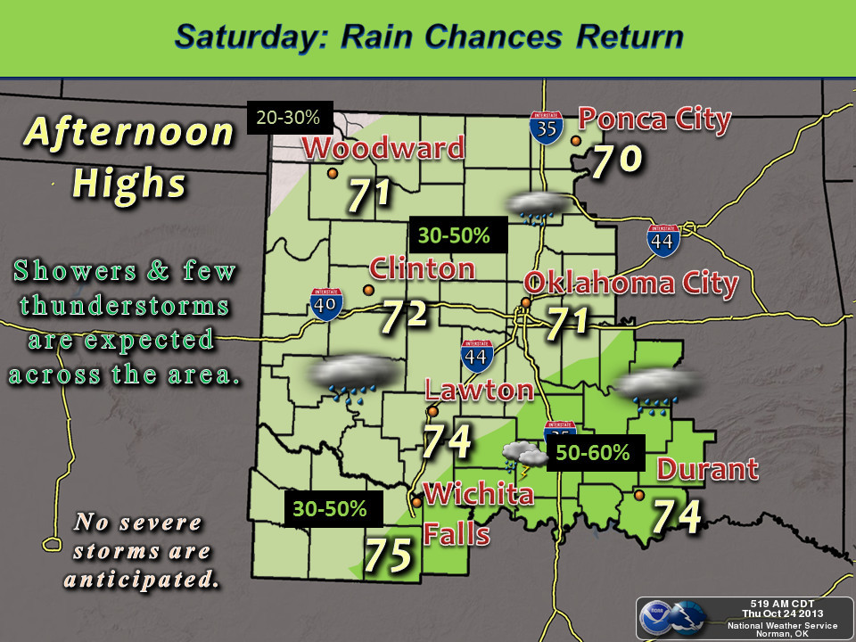
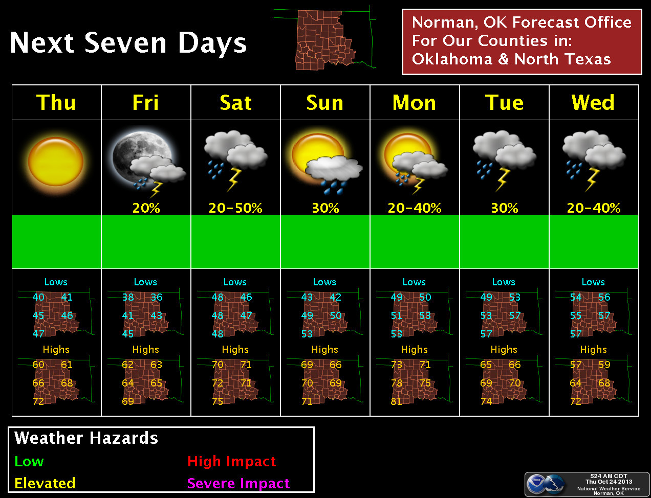
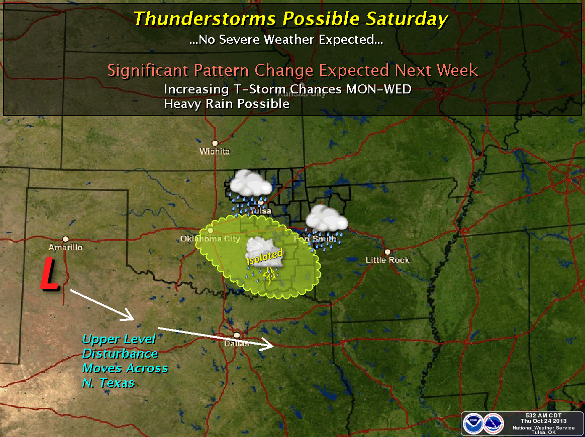
So basically, we're in a holding pattern (holding our breath!) waiting for that
storm system to come ashore so it can be better sampled by our land-based
instruments. That better data is then fed into the forecast models and more firm
forecasts usually result.
Take all talk of snow and ruined Halloweens and other such matters with a grain
of salt for now. This is not an official Braum's Bread and Milk Emergency just
yet. And remember, you'll hear it here last!
Gary McManus
Associate State Climatologist
Oklahoma Climatological Survey
(405) 325-2253
gmcmanus@mesonet.org
October 24 in Mesonet History
| Record | Value | Station | Year |
|---|---|---|---|
| Maximum Temperature | 96°F | GRA2 | 2003 |
| Minimum Temperature | 20°F | BEAV | 2005 |
| Maximum Rainfall | 6.72″ | MCAL | 2019 |
Mesonet records begin in 1994.
Search by Date
If you're a bit off, don't worry, because just like horseshoes, “almost” counts on the Ticker website!