Ticker for June 2, 2013
MESONET TICKER ... MESONET TICKER ... MESONET TICKER ... MESONET TICKER ...
June 2, 2013 June 2, 2013 June 2, 2013 June 2, 2013
A May To Remember
There was so much to write about this May, AND I didn't have power after the
storms on Friday, so this is a bit delayed. Please remember the severe weather
and its aftermath is still bit of a fluid situation, so my numbers are strictly
preliminary as it relates to damage assessments, counts, etc.
The entire Ticker staff will be off all of this week out of state, so that in
and of itself should ensure more tranquil weather for Oklahoma.
----------------------------------------------------------------------------------
A May To Remember
In a state so accustomed to highly variable and often tumultuous weather, May 2013
will be long remembered as one of its most notorious. The month began with some
of the coldest late-spring weather in the state's history and finished with a
flourish of violent weather, including one of Oklahoma's worst tornado
disasters on record. Stirring the echoes of May 3, 1999, for many central
Oklahoma residents, a massive and violent tornado churned its path of
destruction from near Newcastle through south Oklahoma City and Moore before
dissipating near Stanley Draper Lake. The tornado reached EF5 level, the
strongest category on the Enhanced Fujita Scale. The tornado had winds
estimated at over 200 mph and reached a maximum damage width of 1.3 miles.
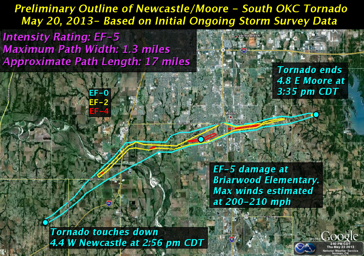
State officials confirmed 24 fatalities due to the twister. The storm injured
over 300 others with preliminary damage estimates totaling over $2 billion
along its 17 mile, 40 minute path. The twister destroyed two Moore elementary
schools, killing seven schoolchildren at Plaza Towers elementary and injuring
many others. One day previous to that event, a violent twister traveled from
east Norman to near McLoud causing two fatalities. That tornado was rated as
an EF4. While numbers are still preliminary, the National Weather Service
counted at least 19 tornadoes between the two days. Officials from the
Oklahoma Department of Emergency Management estimated that the two-day barrage
impacted 2937 homes, businesses and non-residential buildings. The severe
weather was far from over, unfortunately. May's final three days saw a flurry
of dangerous weather, culminating on its final day. A large tornadic supercell
spawned several tornadoes from El Reno to Moore to southeast Oklahoma City.
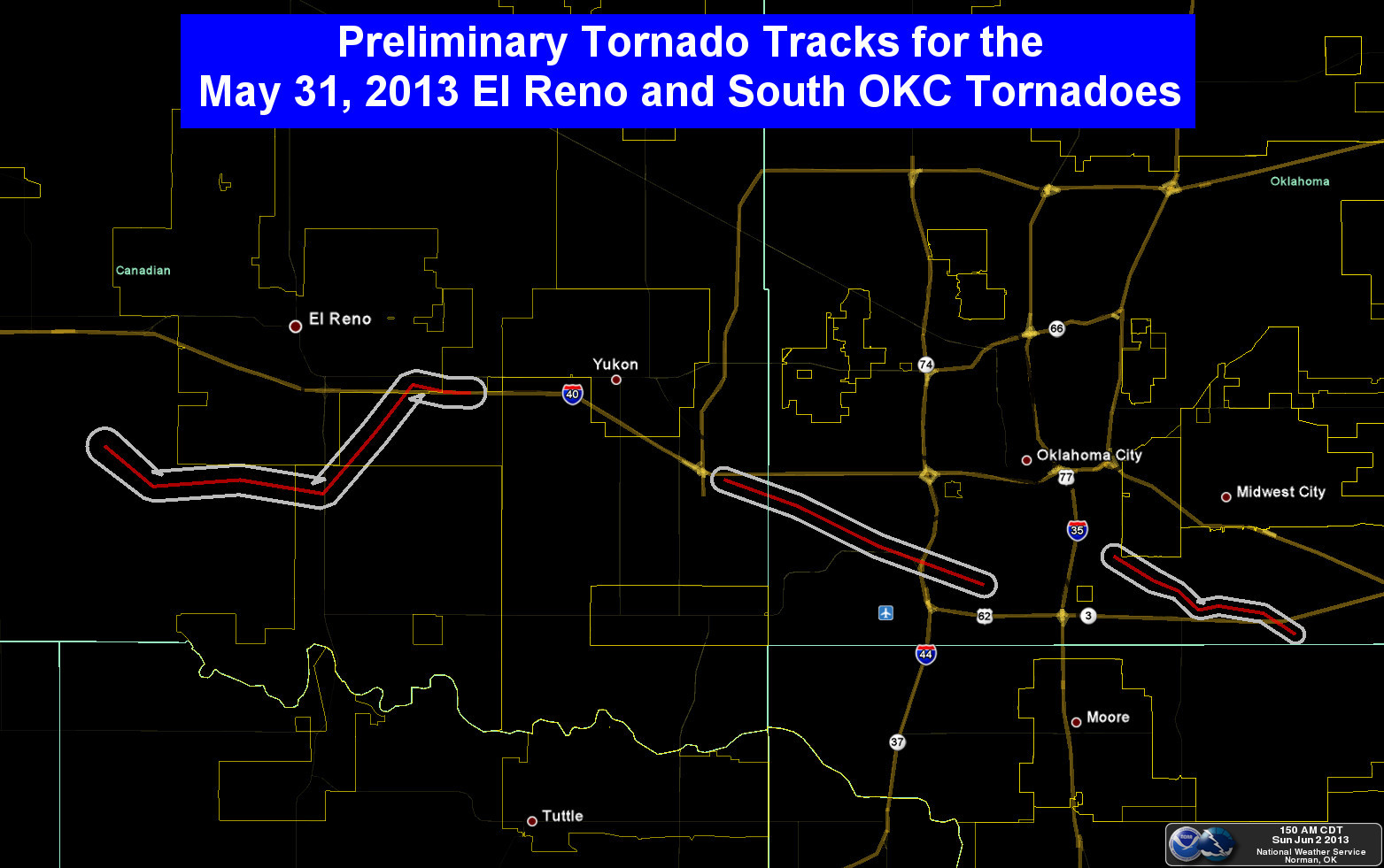
A preliminary count of nine fatalities from those tornadoes, including two
children, brought the year's tally to at least 35. That ties 2013 with 1960 as
Oklahoma's second deadliest tornado year since 1950, bested only by 1999's 42
fatalities. The stationary supercell produced prolific rainfall amounts across
Oklahoma City and resulted in widespread flash flooding. At least two deaths
were blamed on flash flooding from the event, with more possible as searches
continued.
May saw a continuation of the cool weather and drought relief the state has
experienced since mid-February, although western Oklahoma and the Panhandle
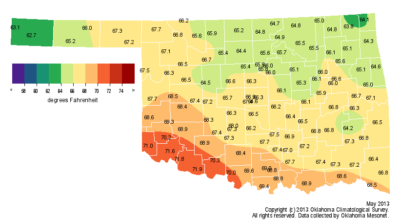
remained parched. According to preliminary data from the Oklahoma Mesonet, the
statewide average temperature finished at 66.8 degrees, more than a degree
below normal.
May was the fourth consecutive month to finish with below normal temperatures,
a feat not seen in Oklahoma since the four month period between December 2009
and February 2010. The below normal finish was mainly due to a cool first half
of the month, particularly during the first week. A freeze occurred across
western and northern Oklahoma as late as May 3, with temperatures dropping into
the 20s as far south as the Red River. Up to 2 inches of snow fell across
northeastern Oklahoma on that day, the latest snowfall on record for many
locations. Tulsa recorded its first ever May snowfall with a trace on May 2.
Numerous records were broken for lowest minimum and lowest maximum temperatures
during those first few days of the month. The climatological spring season of
March-May finished with a statewide average temperature of 56.2 degrees, nearly
3 degrees below normal, to rank as the 11th coolest on record.
The precipitation totals across the state only added to the month's tarnished
legacy. The Mesonet site at Hooker in Texas County recorded a measly 0.08
inches of rain for the month, the second lowest May total for that Panhandle
town since records began in 1906, just 0.04 inches behind 1916's 0.04 inches.
On the other end of the scale, Oklahoma City experienced its wettest May on
record with a whopping 14.52 inches of rain at Will Rogers Airport. That total
becomes Oklahoma City's second wettest month on record, eclipsed only by June
1989's 14.66 inches. Combined with March and April, Oklahoma City's spring
total balloons to 23.18 inches, besting the previous wettest spring mark of
20.31 inches from 1947.
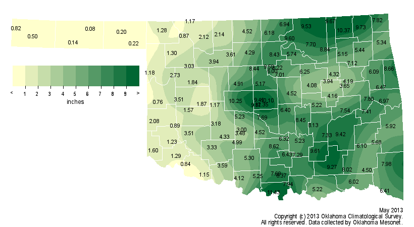
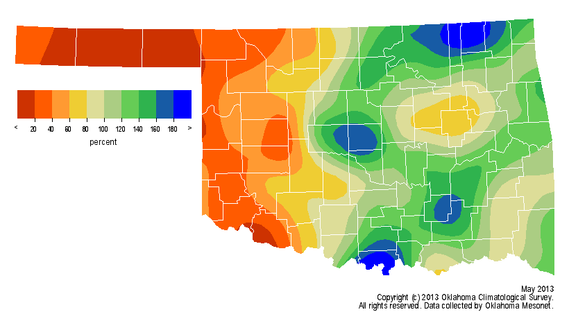
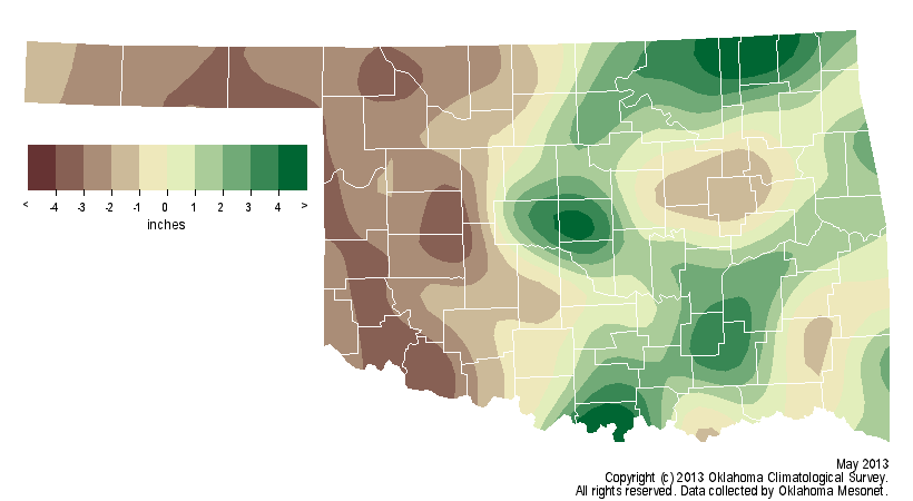
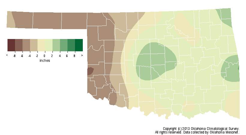
According to data from the Oklahoma Mesonet, the statewide average rainfall
total for May was 4.9 inches, about 0.3 inches below normal. That ranks the
month as the 54th wettest since 1895. A band from south central through
central and northeastern Oklahoma recorded from 9 to 11 inches of rainfall.
Most of the western third of the state recorded less than 2 inches, however,
with much of the Panhandle seeing less than a quarter of an inch. Although the
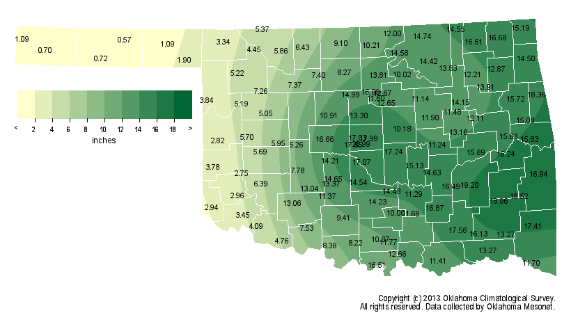
spring season had a rather unremarkable statewide average at 10.65 inches,
about an inch below normal, the stark contrast between western Oklahoma and
the rest of the state was evident in the details. The Panhandle experienced
its fourth driest spring on record while central Oklahoma had its 15th wettest.
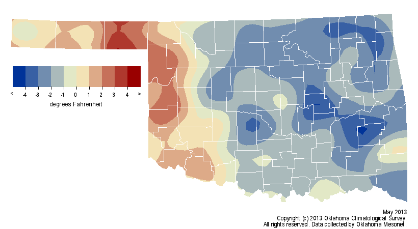
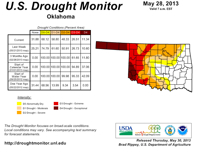
The exaggerated moisture difference produced obvious changes to the U.S.
Drought Monitor by month's end. Extreme and exceptional drought increased
through the western third of the state while drought was eliminated across much
of central and eastern Oklahoma. May's final Drought Monitor map showed about
41 percent of the state being drought free, but 27 percent under the
extreme-exceptional categories.
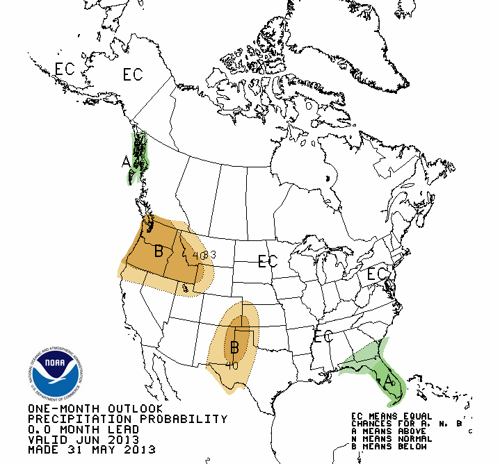
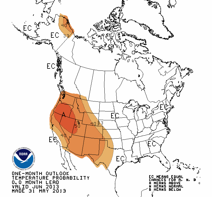
The June outlooks from the Climate Prediction Center (CPC) indicate increased
odds of below normal precipitation and above normal temperature across western
Oklahoma, particularly in the Panhandle. The outlooks are inconclusive across
the rest of the state.
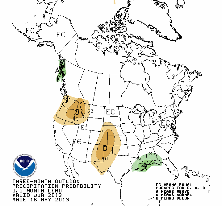
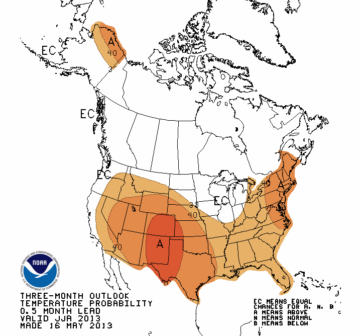
The outlooks for the summer season call for increased odds of below normal
rainfall across the western half of the state and above normal temperatures
over all of Oklahoma.
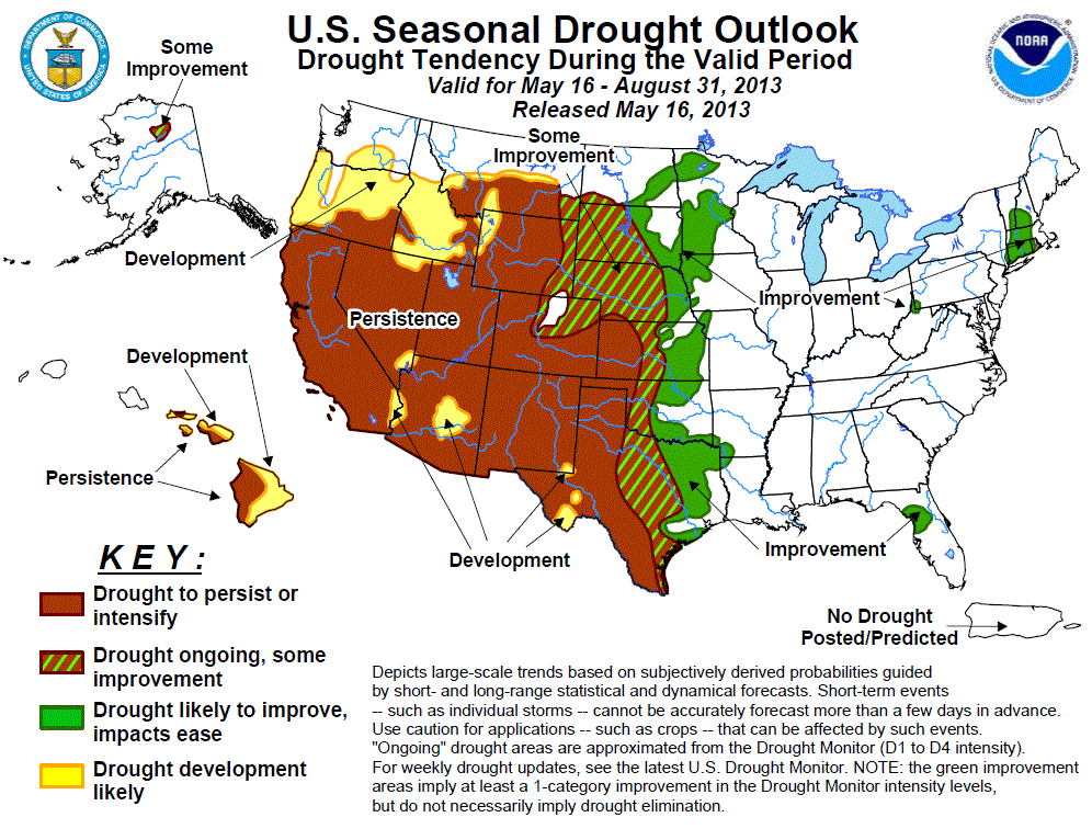
CPC's latest U.S. Seasonal Drought outlook predicts improving drought
conditions across most of Oklahoma through August with the exception of the
extreme western third of the state and the Panhandle. Drought is expected to
persist or intensify in those areas.
Gary McManus
Associate State Climatologist
Oklahoma Climatological Survey
(405) 325-2253
gmcmanus@mesonet.org
June 2 in Mesonet History
| Record | Value | Station | Year |
|---|---|---|---|
| Maximum Temperature | 111°F | MANG | 1998 |
| Minimum Temperature | 42°F | HOOK | 2013 |
| Maximum Rainfall | 5.14 inches | WYNO | 2014 |
Mesonet records begin in 1994.
Search by Date
If you're a bit off, don't worry, because just like horseshoes, “almost” counts on the Ticker website!