Ticker for March 7, 2013
MESONET TICKER ... MESONET TICKER ... MESONET TICKER ... MESONET TICKER ...
March 7, 2013 March 7, 2013 March 7, 2013 March 7, 2013
Disappointment
It's like turning on "M*A*S*H" and seeing Col. Potter instead of Lt. Col. Blake,
seeing Charles Emmerson Winchester III instead of Frank Burns, seeing your
forecast rain totals dwindle from 5 inches in localized areas to an inch. Rain
is rain, however, and we'll take all we can get. The latest forecast totals from
the newly named "WEATHER Prediction Center" formerly "HYDROMETEOROLOGICAL
Prediction Center" (gee...why did they change their name?) still gives Oklahoma
a quarter-inch to more than an inch through the weekend. Not as good as it looked
a week ago, but then again, welcome to the wonderful world of weather forecasting.
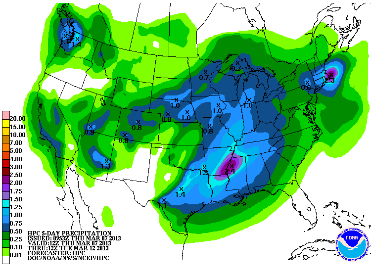
Sorry, Panhandle. You know I love you, but location, location, location. But at
least the rain and snow over the last month or two have provided beneficial
moisture ... enough to give even the parched Oklahoma Panhandle some decent
drought relief. It was the Panhandle's turn this week, as we awaited last week's
snow to melt.
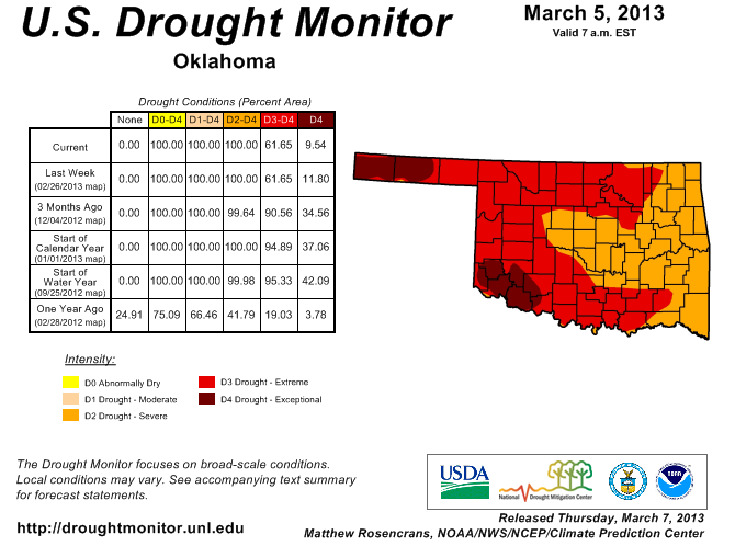
So the state's amount of Exceptional (D4) drought dropped from 12% to about 9.5%.
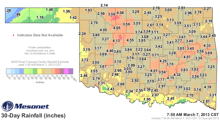
The totals for the last 30 days show why those improvements were warranted, at
least through the eastern Panhandle.
The newest U.S. Drought Outlook was also released this morning, and it still
bodes poorly for Oklahoma. As you can see, this product depicts virtually the
entire state in it's "drought to persist or intensify" area through the end of
May. They at least give us the same caveat they did two weeks ago concerning
the possibility of May rainfall:
"The one significant wild card through the Plains and adjacent
Rockies is May - a wet month with sizeable precipitation normals
as mentioned already. Moisture deficits could rise or fall quickly
once the month gets underway if precipitation is significantly
above or below normal. For the large area of drought from the Plains
westward to the Pacific Coast, forecast confidence is moderate to high,
with less certainty along northern and eastern parts of the region,
where the monthly and 3-month outlooks do not favor drier than normal
conditions as they do elsewhere."
I'll give my own caveat. The skill of those long-range forecasts, especially
for precipitation, are not that great this time of year. Plus, those were released
nearly three weeks ago, so they are a bit dated. Springtime precipitation is
incredibly difficult to predict because of its convective nature. Where will
the storms set up, form a line? How fast will they move? Where will they form,
move, and then form again over the same area? Very difficult. The key, however,
is the storm systems that produce those thunderstorms. That's they key, and
they see those chances being somewhat diminished.
More disappointment will come if that Seasonal Drought Outlook verifies. Summer
will be brutal and a complete third year of drought will become much more
likely.
How disappointing? Think "AfterM*A*S*H."
Gary McManus
Associate State Climatologist
Oklahoma Climatological Survey
(405) 325-2253
March 7 in Mesonet History
| Record | Value | Station | Year |
|---|---|---|---|
| Maximum Temperature | 87°F | HOLL | 2006 |
| Minimum Temperature | 8°F | SEIL | 2008 |
| Maximum Rainfall | 3.76 inches | PRYO | 1998 |
Mesonet records begin in 1994.
Search by Date
If you're a bit off, don't worry, because just like horseshoes, “almost” counts on the Ticker website!