Ticker for January 9, 2013
TICKER UPDATE: USDA is getting off to a very early start in 2013 with
secretarial drought declarations in nearly 600 counties (including all of
Oklahoma's 77 counties). The department, recognizing that drought is not going
away anytime soon, wants to be proactive in helping producers procure
low-interest loans.
You can read more about the disaster declaration here:
http://1.usa.gov/VT2xYm
And see the declaration map here:
http://www.usda.gov/documents/usda-drought-fast-track-designations-010913.pdf
This bit from the declaration news release shows the importance of the U.S.
Drought Monitor depiction for the state when it comes to relief efforts:
"The 597 counties have shown a drought intensity value of at least D2
(Drought Severe) for eight consecutive weeks based on U.S. Drought
Monitor measurements, providing for an automatic designation."
Gary McManus
Associate State Climatologist
Oklahoma Climatological Survey
(405) 325-2253
gmcmanus@mesonet.org
MESONET TICKER ... MESONET TICKER ... MESONET TICKER ... MESONET TICKER ...
January 9, 2013 January 9, 2013 January 9, 2013 January 9, 2013
Rain please. Pretty please?
Okay, now she's just messing with us.
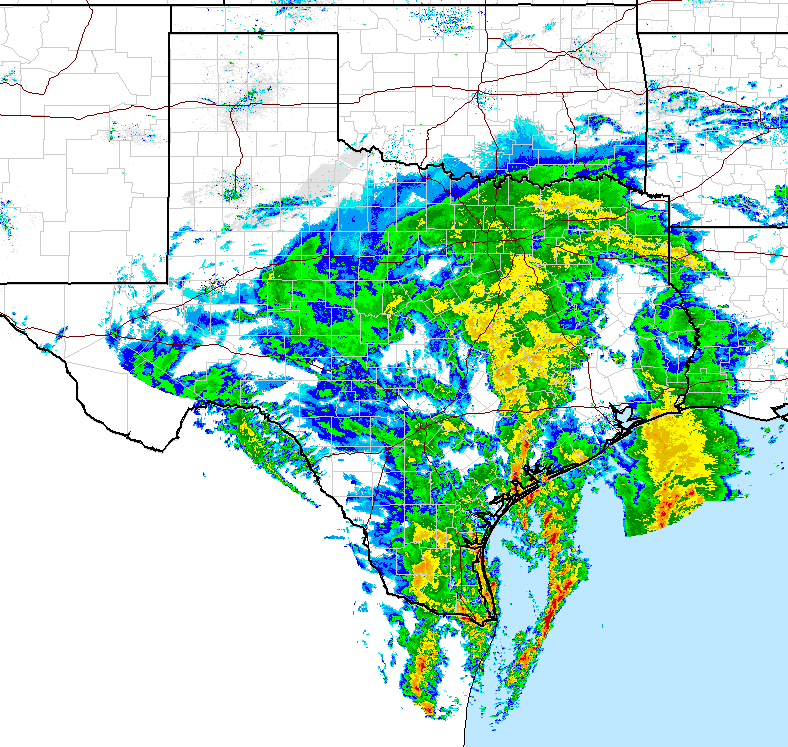
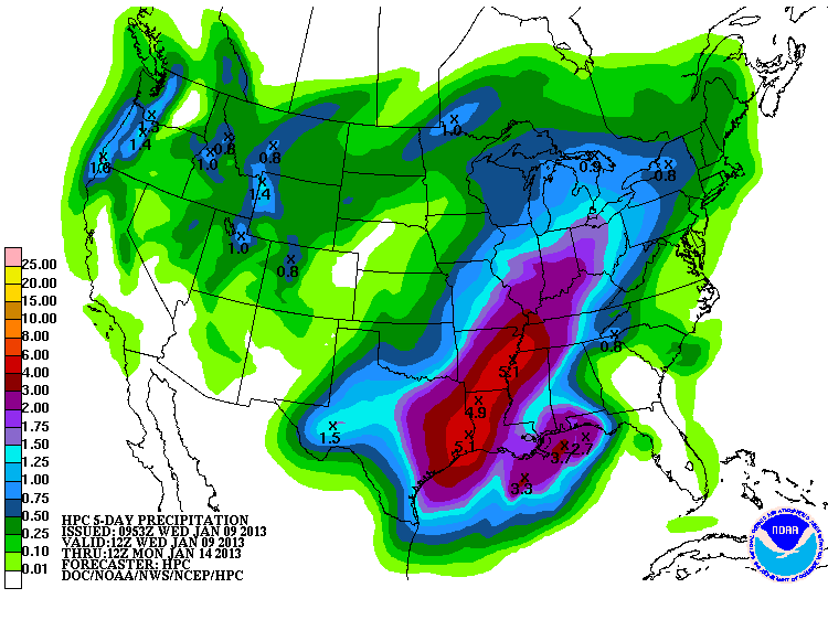
Come on, now. What did we ever do to Texas? Or Mother Nature? And what has Texas
done for Mother Nature that we haven't done? It's all rather complicated. But, I
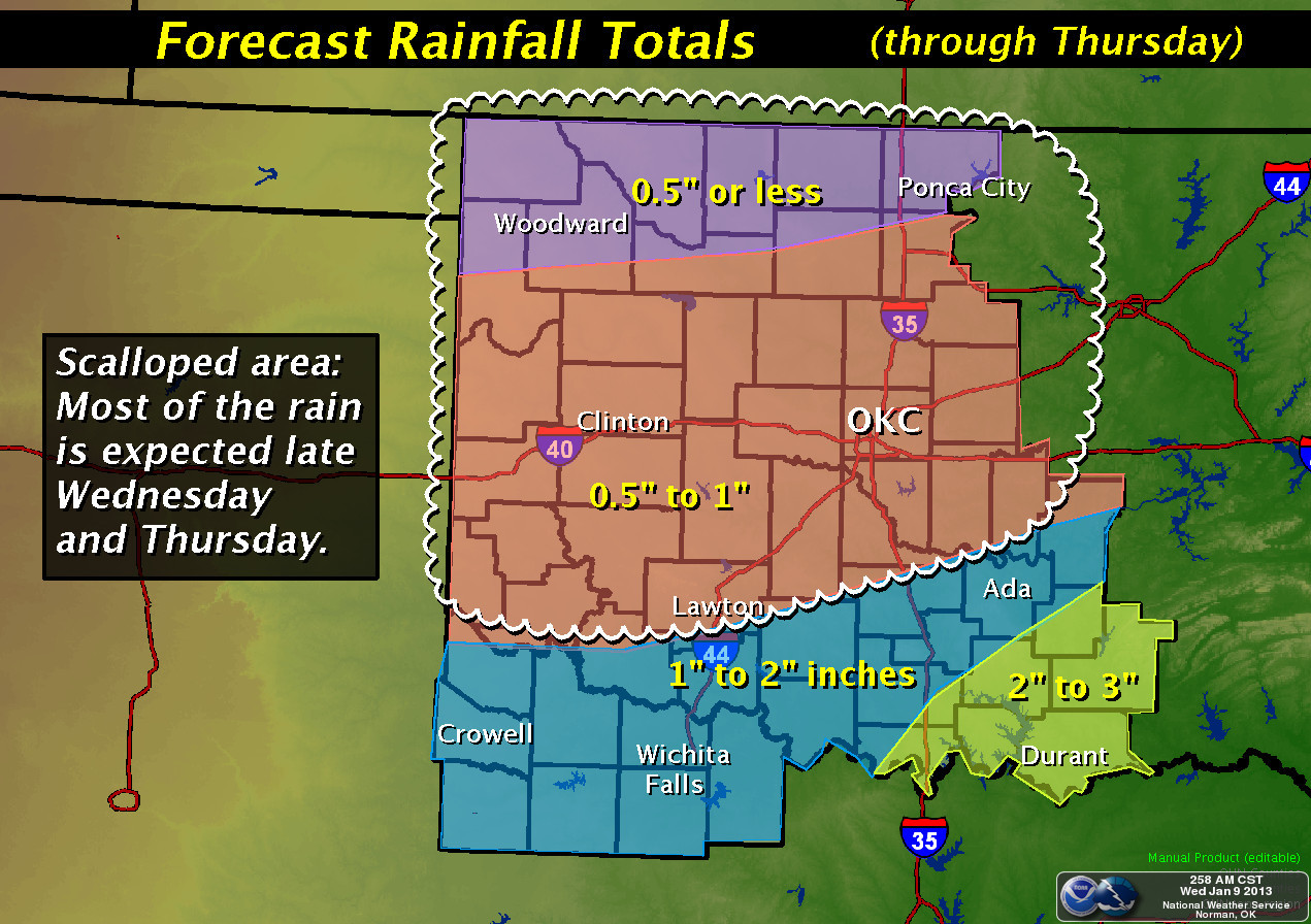
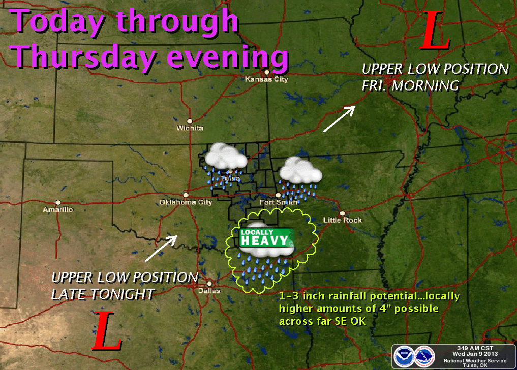
am still seeing rain in the forecast for Oklahoma later today and overnight into
tomorrow. Maybe not as much as previously thought, but still about a half-inch to
more than 2 inches. For the hardest hit areas of northern Oklahoma, they appear
to be getting the least, unfortunately. The southeast, as is characteristic for
that part of the state, appears to be receiving the more generous totals.
We have received some good rains down south already. The Mesonet totals range
from just a smattering west of I-35 to more than an inch down in McCurtain County.
What can I say ... the Ticker rainfall curse appears to still be in effect.
-------------------------------------------------------------------------------
Yesterday we saw confirmation from the National Climatic Data Center that
Oklahoma experienced its warmest year on record. I've been calling it "the
year that never got cold." That's accurate up until the last week of the year,
basically. But we can now plot 2012 on our Annual, Statewide climate trends
graph.
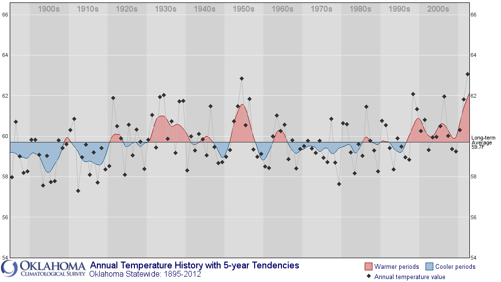
You can see where the state has been warmer on a yearly average basis over the
last 15 years or so. Contained within that annual signal you can see differing
changes in our seasonal temperatures.
winter: 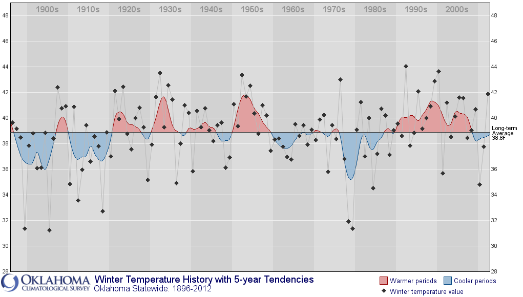
spring: 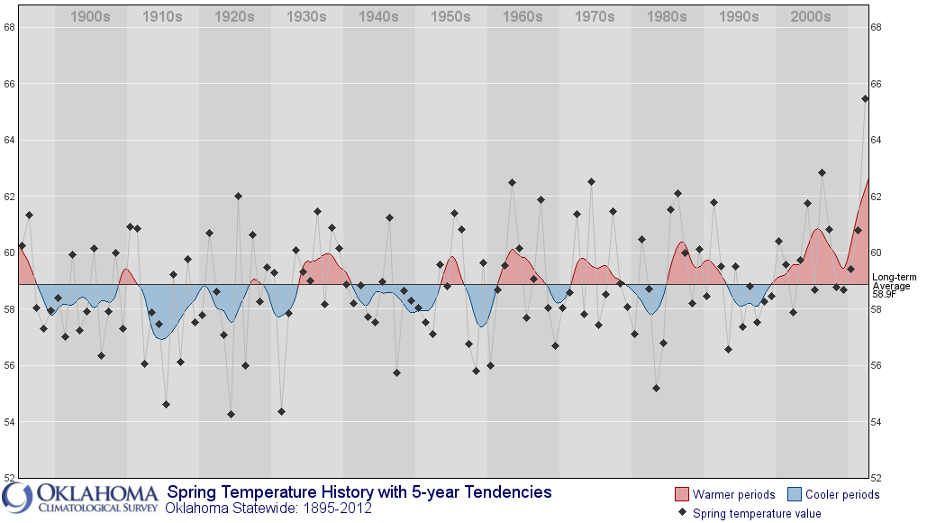
summer: 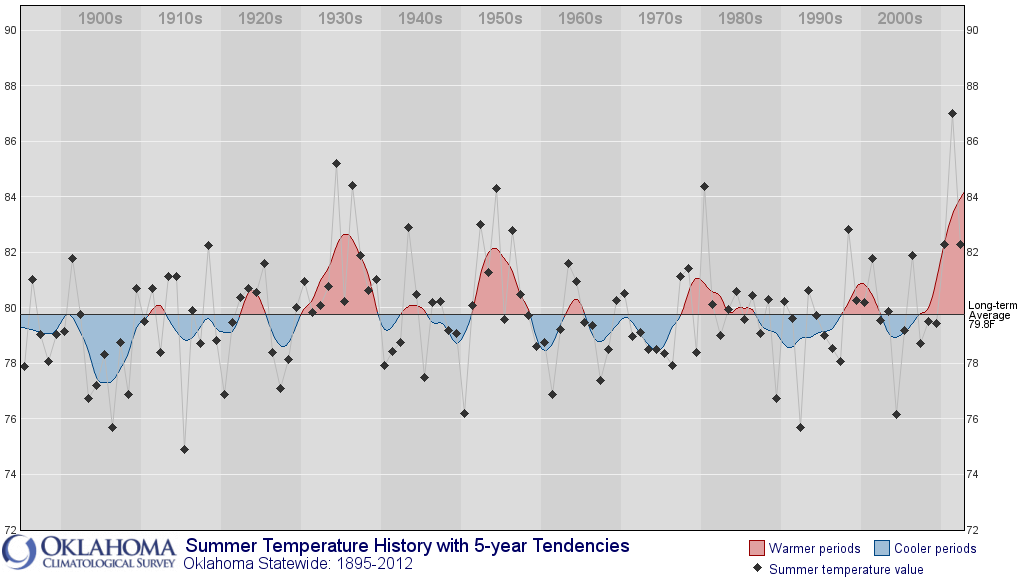
fall: 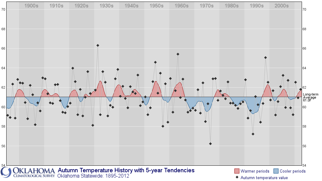
That summer graph correlates quite well with drought, and you can see summer
2011 is a monster outlier. Remember, it broke the record for warmest summer for
any state going back to 1895. Some may not remember 2010 being so hot, but we
also had a pretty severe flash drought in July and August. Springs have also
been warmer here lately, and also coming a bit earlier. The cold winters of
2009-10 and 2010-11 correlate with the strongly negative periods of the Arctic
Oscillation Index (AO), which we're about to see again here in a week or so.
Autumn is ... well, Autumn.
We can also take a look at the precipitation graph. What you're gonna see is
a two-year period of low precipitation, the likes of which we haven't seen
since probably the 1950s.
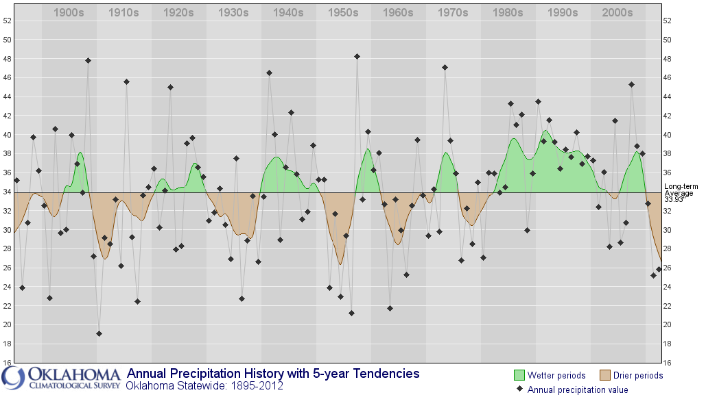
Within that signal, you can see not only have our last couple of Mays hurt us,
but in particular the last two Junes have really killed our spring rainy
seasons. And that's allowed drought (and heat) to flourish when we hit summer.
May: 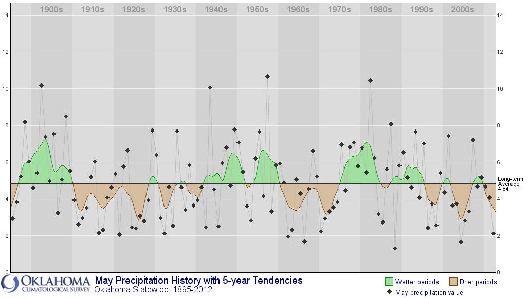
June: 
One of the odd things between the two annual graphs, precip and temperature, is
that the hot years from the 1930s and 1950s correspond to bigtime droughts, but
the heat of the last 15 years or so correspond to an unusually consistent wet
period. The extreme heat still corresponds to the drought years, however.
You can check out the temperature and precipitation seasonal and monthly
averages for yourself here:
http://bit.ly/10eZmlb
-------------------------------------------------------------------------------
Now, bring on the rain? Please?
Gary McManus
Associate State Climatologist
Oklahoma Climatological Survey
(405) 325-2253
gmcmanus@mesonet.org
January 9 in Mesonet History
| Record | Value | Station | Year |
|---|---|---|---|
| Maximum Temperature | 81°F | ALTU | 2009 |
| Minimum Temperature | -4°F | JAYX | 2010 |
| Maximum Rainfall | 1.09 inches | BROK | 2013 |
Mesonet records begin in 1994.
Search by Date
If you're a bit off, don't worry, because just like horseshoes, “almost” counts on the Ticker website!