Ticker for January 2, 2013
MESONET TICKER ... MESONET TICKER ... MESONET TICKER ... MESONET TICKER ...
January 2, 2013 January 2, 2013 January 2, 2013 January 2, 2013
Oklahoma's record for warmest year falls
A slide back to true wintry weather, the likes of which had not been seen across
Oklahoma since early February 2011, was not enough to prevent the inevitable.
Although the official numbers will not be released by the National Climatic Data
Center (NCDC) for a few more days, it appears likely that 2012 will go down in
the record books as Oklahoma?s warmest year on record. Those records date back to
1895. Preliminary data from the Oklahoma Mesonet indicate a statewide average
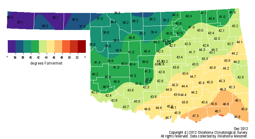
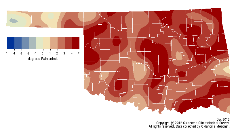
temperature of 41.9 degrees for December. That is 2.9 degrees above normal and
ranks the month as the 27th warmest December on record.
More importantly, it would give 2012 a sizeable lead over 1954 and the likely
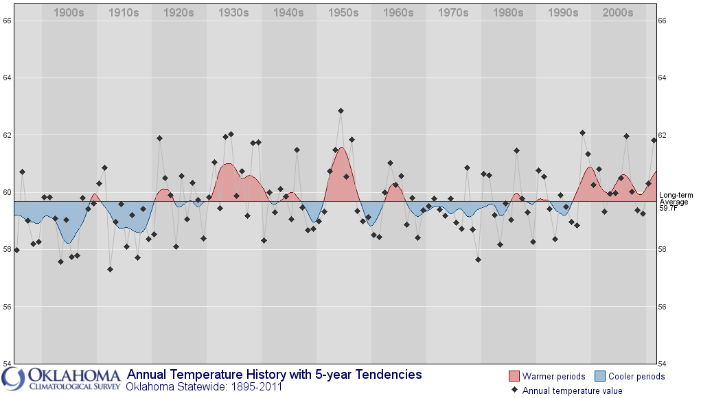
title of warmest calendar year on record for the state at 63.1 degrees, 3.5
degrees above normal.
According to data from the National Weather Service (NWS), Oklahoma City and
Tulsa also eclipsed their previous warmest years on record with 64.1 degrees
and 64.7 degrees, respectively. Oklahoma City?s previous best was 63.9 degrees
from 2006 and Tulsa?s was 63.7 degrees from 1921 and 1954. Oklahoma was not
alone in dealing with unusual warmth during 2012. Officials from NCDC say it
is a "virtual certainty" that 2012 will become the warmest year on record
across the contiguous United States.
Oklahoma?s previous calendar year record of 62.8 degrees from 1954 was in
jeopardy from the year?s opening bell. January finished 6.5 degrees above
normal to rank as the 11th warmest on record, and the heat continued to build
from there. March far outpaced its previous record at more than 9 degrees above
normal and propelled Oklahoma to its warmest spring on record. The summer may
not have matched 2011?s record level, the hottest for any state since records
began in 1895, but it was extreme by any other measure. The statewide average
of 82.2 degrees ranked as the 11th warmest June-August period on record.
October was the only month during 2012 to end with below normal temperatures.
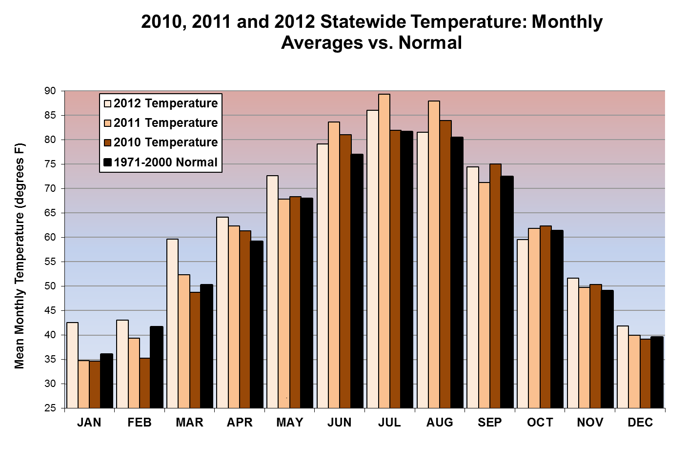
December became the 27th month out of the last 33 to finish warmer than normal,
a streak that began with April 2010. Buoyed by the record summer of 2011 and
the extended warmth of 2012, the statewide average temperature estimate of 62.4
degrees for the two years combined exceeds the previous record of 62.1 degrees
from 1953-1954. The lowest temperature recorded by the 120 Mesonet sites during
2012 was the 1 degree below zero reading at Beaver on Dec. 26. The highest
temperature of 115 degrees was recorded at Kingfisher on Aug. 1.
Drought continued to dominate Oklahoma?s weather story for the second
consecutive year. A period of storminess during the year?s final week provided
beneficial moisture to parts of Oklahoma, but December finished dry
nonetheless. According to estimates from the Oklahoma Mesonet, the statewide
average precipitation total during December was 1.06 inches, about an inch
below normal and the 38th driest on record.

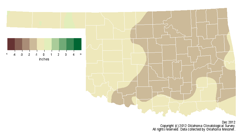

That brings the estimate for 2012 to 25.92 inches, 10.77 inches below normal
and just slightly ahead of 2011?s 25.23 inches. The highest total recorded by
the Mesonet during 2012 was Clayton?s 40.6 inches. Kenton brought up the rear
at 11.7 inches.
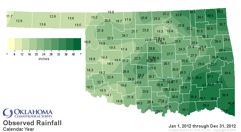
That two-year combined total of 51.15 inches is the fourth lowest on record.
The 1909-1910 total of 46.21 inches is the lowest since records began in 1895.
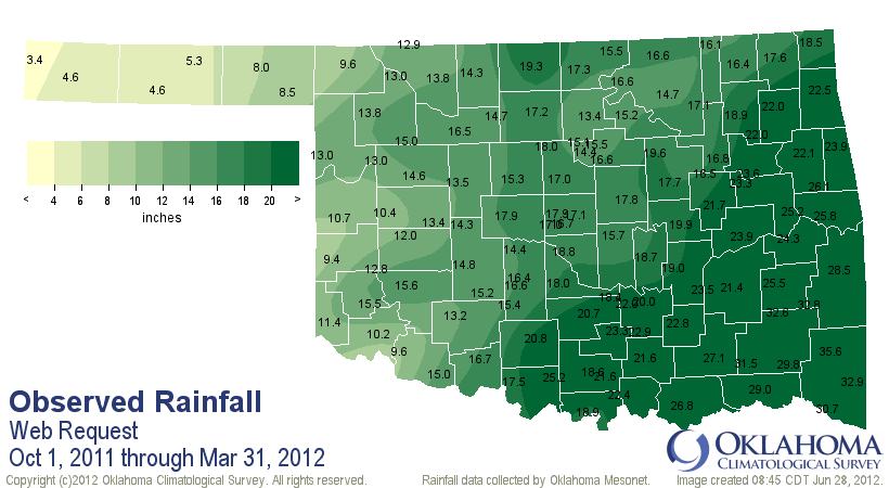
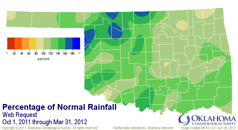
Most of the state experienced a short reprieve from the devastating 2011
drought episode thanks to abundant rains from October 2011-March 2012, the 12th
wettest October-March period on record.
Only 15 percent of Oklahoma was experiencing drought on May 15 according to the
U.S. Drought Monitor.
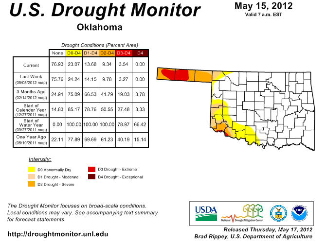
As summer approached, however, the heat mounted as did the rainfall deficits.
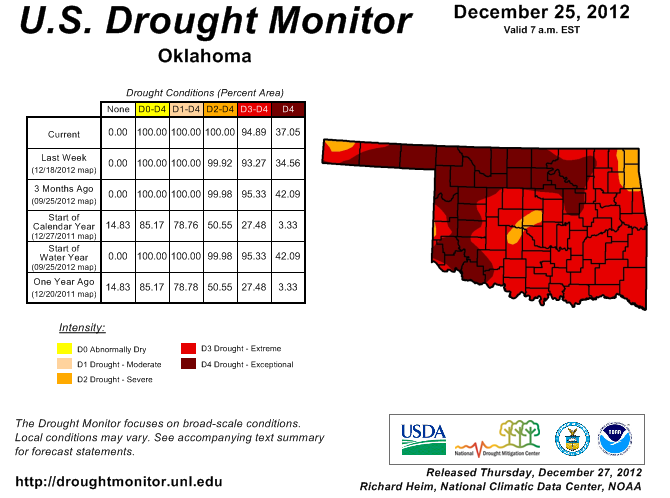
The May-December statewide average of 13.96 inches was the driest such period
on record and led the entire state to being depicted in at least severe drought
conditions on the year?s final U.S. Drought Monitor map. Over 37 percent of the
state was considered to be under exceptional drought, the Monitor?s worst
designation.
More than $400 million in damage to agricultural interests occurred during
2012 according to experts from Oklahoma State University. That brings the
two-year agricultural damage estimate to more than $2 billion.
Gary McManus
Associate State Climatologist
Oklahoma Climatological Survey
(405) 325-2253
gmcmanus@mesonet.org
January 2 in Mesonet History
| Record | Value | Station | Year |
|---|---|---|---|
| Maximum Temperature | 80°F | BURN | 2004 |
| Minimum Temperature | -10°F | KENT | 2013 |
| Maximum Rainfall | 2.55″ | CLOU | 2005 |
Mesonet records begin in 1994.
Search by Date
If you're a bit off, don't worry, because just like horseshoes, “almost” counts on the Ticker website!