Ticker for December 18, 2012
MESONET TICKER ... MESONET TICKER ... MESONET TICKER ... MESONET TICKER ...
December 18, 2012  December 18, 2012  December 18, 2012  December 18, 2012


Bread and Milk Threat Alert

This is a test of the Ticker Broadcasting System (TBS). Should you find
yourself in a bread and milk emergency, proceed to the nearest Braum's and
await further instructions (or just buy some bread and milk and then leave).
Yes, the secret is out of the bag ... there is a possible winter storm
appearing on the horizon, right around Christmas Day. The TV folks are talking
about it, the NWS forecasters are talking about it (screaming, in fact):

NWS-Norman - SEVERAL MODELS CONTINUE TO HINT AT A MUCH STRONG SYSTEM
IMPACTING THE SOUTHERN PLAINS AROUND CHRISTMAS.  MODEL
TO MODEL RUN CONSISTENCY IS NOT GOOD AND GFS ENSEMBLES
HAVE A WIDE RANGE OF SOLUTIONS. VERY COLD AIR WILL BE
LURKING...SO THE POTENTIAL FOR SOME WINTER WEATHER EARLY
NEXT WEEK/MID WEEK IS POSSIBLE.

NWS-Tulsa - NEEDLESS TO SAY...THE HOLIDAY FORECAST FOR EARLY NEXT WEEK LOOKS
INTERESTING. ECMWF BOMBS A MID-LEVEL UPPER LOW FROM THE TX PANHANDLE
CHRISTMAS MORNING INTO MO BY 12Z/26. THIS TRACK AND FORECAST THERMAL
PROFILES WOULD SUPPORT SIGNIFICANT SNOWFALL ACROSS THE AREA LATE
CHRISTMAS DAY AND NIGHT. THE GFS OFFERS A SOMEWHAT SIMILAR
SOLUTION...ALTHOUGH ABOUT 24 HOURS LATER THAN THE ECMWF (AND THERMAL
FIELDS ARE A BIT WARMER). UNCERTAINTY REMAINS HIGH AND DETAILS WILL
OBVIOUSLY CHANGE OVER THE NEXT SEVERAL DAYS...HOWEVER THE PUBLIC IS
URGED TO CLOSELY MONITOR THE CHRISTMAS TIME FORECAST.

As responsible weather-ologists, we're using all the cautionary words we can
think of since we're still 7-8 days out from the forecast storm. The different
computer forecast models will continue to battle it out for the next few days
and hopefully they will start to synch up and give the forecasters something a
bit more credible to work with.

So you can take these forecasts in one of two ways:

1) The storm is still a long ways away and lots can change by then. You are
cautioned to wait until the storm draws closer to make your plans. This thing
could go 500 miles north or south.

or

2) Wow, if we can see the storm starting to come together this far out, it could
be a doozy!

So either way, our rear ends are covered. What a gig we have!!

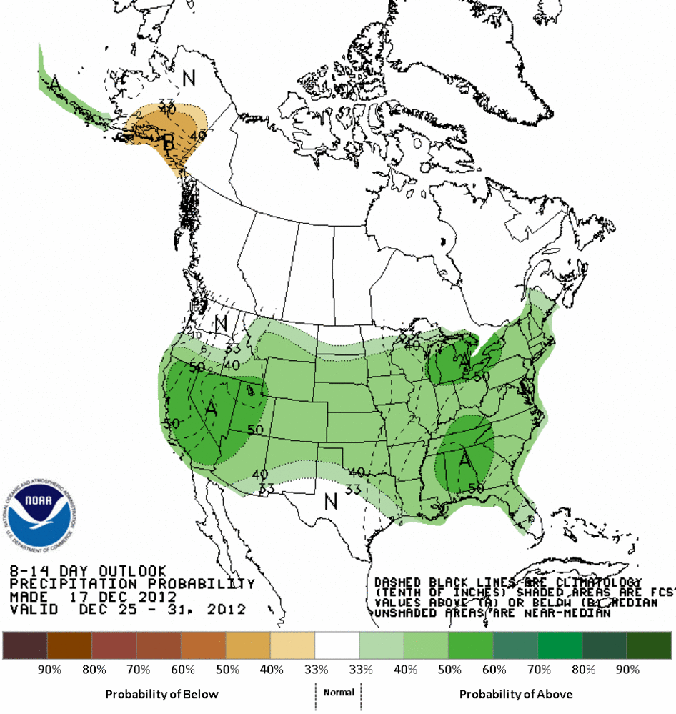
What I'm looking for, however, is the moisture we might get. I'm not in favor
of a blizzard. That tends to blow where it shouldn't and the fields needing
soil moisture tend to miss out. Better a good rain over that type of system.
The CPC is definitely picking up on the chances for above normal moisture.


Before we even get close to that, we have to run the gauntlet of extreme fire
danger over the next several days. Low relative humidity and very strong winds
with the next relatively dry frontal passage tomorrow will provide the perfect
ingredients for fire danger. Winds will be gusting to over 50 mph tomorrow, so
be prepared for all the fun that comes with that.


Now stay tuned to the Ticker Broadcasting Network (we upgraded from "System"
since we started writing ... turns out "TBS" is already taken. Wait, "TBN" is
also taken. Oh well, sue us. We ain't got nothing anyway)! We will be the
first to tell you next week if it did or didn't happen.

Gary McManus
Associate State Climatologist
Oklahoma Climatological Survey
(405) 325-2253
gmcmanus@mesonet.org
December 18 in Mesonet History
| Record | Value | Station | Year |
|---|---|---|---|
| Maximum Temperature | 76°F | HUGO | 2006 |
| Minimum Temperature | -18°F | EVAX | 2016 |
| Maximum Rainfall | 1.43″ | WEST | 1995 |
Mesonet records begin in 1994.
Search by Date
If you're a bit off, don't worry, because just like horseshoes, “almost” counts on the Ticker website!