Ticker for December 12, 2012
MESONET TICKER ... MESONET TICKER ... MESONET TICKER ... MESONET TICKER ...
December 12, 2012  December 12, 2012  December 12, 2012  December 12, 2012


Potpourri

Cccccccccold!!!

It says a lot about how warm (or how not cold) our spring was this year when a
three-day stretch of winter can beat it in the hours below freezing department.
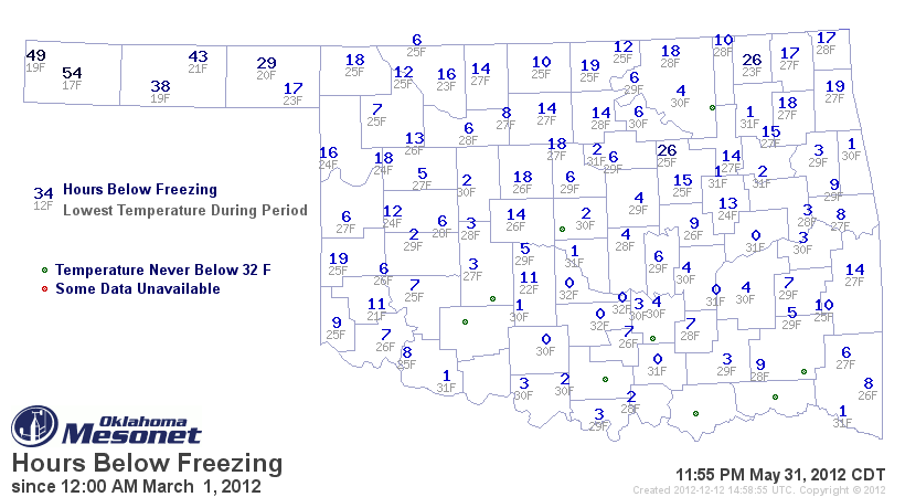
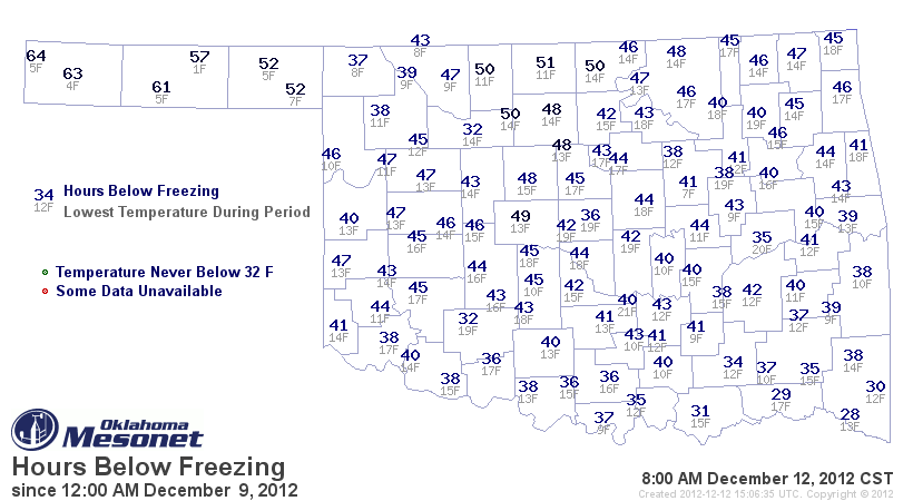
Check out the hours spent below freezing, as measured by the Mesonet, versus what
we've seen since Sunday. And remember climatologists define spring as March-May.
Brief tangent, we could have it track closer to the astronomical spring and make
April-June the spring months, but when you think of June, do you think of spring
or summer? There you go. It's all done for more precise record-keeping,
regardless, since astronomical seasons' starting and ending dates are mobile.


There were nine Mesonet stations that didn't even reach the freezing mark during
spring. You may be thinking "Well duh, it was spring!" First off, I object to
the "duh"!! Secondly, it can still get fairly cold around here during March and
April. Normal lows are in the 20s in early March across northern Oklahoma, after
all.

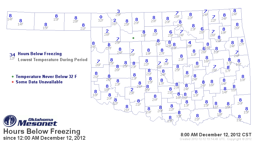
Heck, we beat part of the state's spring with just midnight-8am today!


-------------------------------------------------------------------------------

One

One is an interesting number. Some say it's the loneliest number that you'll
ever do. It's also the number of confirmed tornadoes in the state between June
and December. It sort of snuck in there, but the NWS Norman office did confirm
a tornado down in Carter County on October 13 near Healdton. The twister injured
two folks in the area as well. That brings the 2012 twister count to 62. Of that
total, 52 occurred in April, a new record for that month (beating the new record
of 50 set in April 2011). Definitely a slowdown from our totals of 102 and 119
in 2011 and 2012, respectively. You only have to go back to 2009 to find a
smaller count, however, when 34 were reported for that entire year.
-------------------------------------------------------------------------------

604

Another interesting number. From my count, one greater than 603, yet one less
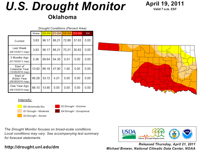
that 605. But it's also the number of consecutive days that some part of Texas
County has had the Extreme (D3) drought designation from the U.S. Drought
Monitor. That goes all the way back to the report from April 19, 2011.


That doesn't mean the drought was suddenly worse that week. It merely means
that's when we were able to catch up with the drought impacts. I would imagine
folks out there were seeing pretty bad impacts before that. In fact, I KNOW
they were. Dust Bowl, anyone?


Texas County first entered moderate drought way back on December 28, 2010, again
according to the U.S. Drought Monitor as opposed to possible drought conditions
prior to that. That makes the total number of consecutive days in drought for
that county 717. Somewhere in the state has been under at least moderate
drought since October 26, 2010 ... 779 days.
-------------------------------------------------------------------------------
11

That's the total number of Christmas Days since 1891 in Oklahoma City on which
snow actually fell according to our Elven friends at the Norman NWS office.
Eight of those days a trace was all that was reported, so three days with REAL
snow, I guess. The highest total came on Christmas Day back in 1914 with 6.5
inches. The other two totals ... a half an inch in 1975 and a third of an inch
in 1939. So a 9% (11 out of 121) chance to see at least a trace of
snow on Christmas Day in Oklahoma City, climatologically speaking. But only
2% (3 out of 121) with at least a tenth of an inch of snow.

Now snow on the ground, that's a bit different. We all remember the Christmas
Eve blizzard from 2009. That left 14 inches of snow on the ground at Will Rogers
Airport. There was also two inches on the ground Christmas Day 2002, and an
inch in 1975. There have been 12 days with at least a trace of snow on the
ground on Christmas Day, or about 10%. It takes at least an inch on the ground
to officially be a white Christmas, so that has occurred 5% of the time (6 out
of 121).

http://www.srh.noaa.gov/oun/?n=climate-okc-christmasday

Mrs. Claus, on temporary assignment at the NWS Tulsa office, reports five days
since 1900 with enough snow on the ground to classify as a white Christmas.
Their maximum was 6 inches in 2009, obviously. The other four were 1966, 1983,
2000 and 2002. They have had 11 days with at least a trace of snow on Christmas
Day, with a maximum of 1.3 inches back in 1975. Nationally, you can see most of
the southern third of the country is in Grinch territory at less than a 5%
probability for a white Christmas.

http://www.srh.noaa.gov/tsa/?n=climo_tul_xmas

If'n you want a White Christmas, this area usually ain't the place to be. A
nice sunny Christmas with lots of brown and yellow? That we can do.

Gary McManus
Associate State Elf
(405) 325-2253
gmcmanus@mesonet.org
December 12 in Mesonet History
| Record | Value | Station | Year |
|---|---|---|---|
| Maximum Temperature | 77°F | KENT | 2021 |
| Minimum Temperature | 2°F | BEAV | 2000 |
| Maximum Rainfall | 2.84″ | MTHE | 2015 |
Mesonet records begin in 1994.
Search by Date
If you're a bit off, don't worry, because just like horseshoes, “almost” counts on the Ticker website!