Ticker for May 29, 2012
MESONET TICKER ... MESONET TICKER ... MESONET TICKER ... MESONET TICKER ...
May 29, 2012       May 29, 2012       May 29, 2012       May 29, 2012


Die Easy

"You asked for miracles, Theo, I give you the F...B...I."

Why am I quoting Alan Rickman from "Die Hard" (aka the film's "who said we were
terrorists?" antagonist and thief Hans Gruber)? Well, I can't really quote
Bruce Willis because of the language, can I?? But given the budding drought,
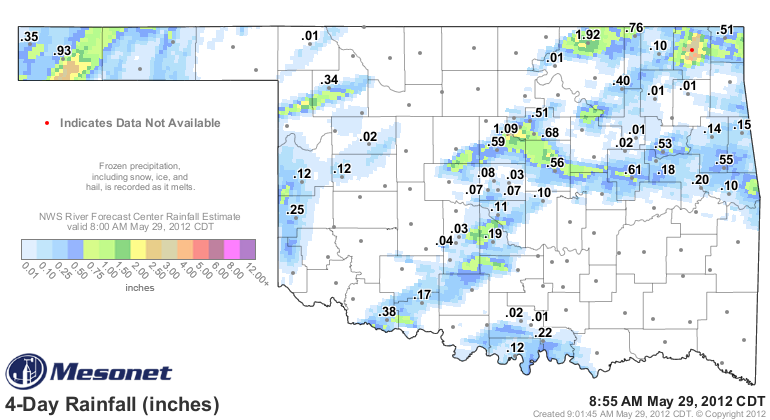
consider this 5-day rainfall prediction and tell me that it isn't arriving in
the nick of time, much like FBI Agent Johnson and Special-Agent Johnson (no
relation) did in "Die Hard."


After the dry May we've had, that rainfall will go a long way towards relief,
especially as climatological summer begins on June 1 and the real heat saunters
back into the state. The fireworks related to the current storm system (the
real miracle bringer in our movie) started this weekend with a goodly amount of
rain in very localized areas.


Cimarron and Craig counties got the best totals, with 3.29 inches recorded at
our Vinita Mesonet site and radar estimates of 2-3 inches southeast of Boise
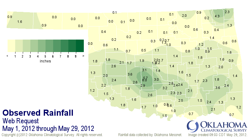
City. That brings our May 1-29 (9 a.m.) statewide average Mesonet total up to
1.33 inches, so we have avoided the driest May on record (May 1988, 1.3 inches).
Remember, NCDC has the official numbers and those aren't finalized for a few
months as more and more data trickles in. The Mesonet is a fairly good indicator
of the final rankings, however, and more than half of the Mesonet stations are
used in the NCDC final numbers. Here is the May 1-29 rainfall map from the
Mesonet.


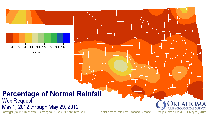
That looks good in spots, but still woefully inadequate right before summer, as
the percent of normal map illustrates. Note that the 5-6 inches that fell in
the small area in Grady County is above normal for the period, but too localized
to show as being so on the map.


The heat has remained in place. It appears likely May will be one of our five
warmest on record this year. The May statewide average right now is 72.3 degrees
which would put it in fifth place. Our spring (March-May) and January-May
periods are going to absolutely SMASH the previous heat records. All of that
means higher than normal water stress.

It's still May, and we are still in the midst of our wettest part of the year.
There is still ample time for relief before the true summer heat sets in. But,
do I really think this current storm can defeat the creeping drought?

Yippee ki-yay!

Okay, one sanitized John McClane quote. It had to be done.

Gary McManus
Associate State Climatologist
Oklahoma Climatological Survey
(405) 325-2253
gmcmanus@mesonet.org
May 29 in Mesonet History
| Record | Value | Station | Year |
|---|---|---|---|
| Maximum Temperature | 107°F | BEAV | 2011 |
| Minimum Temperature | 42°F | KENT | 2019 |
| Maximum Rainfall | 5.19″ | HECT | 2001 |
Mesonet records begin in 1994.
Search by Date
If you're a bit off, don't worry, because just like horseshoes, “almost” counts on the Ticker website!