Ticker for April 30, 2012
MESONET TICKER ... MESONET TICKER ... MESONET TICKER ... MESONET TICKER ...
April 30, 2012 April 30, 2012 April 30, 2012 April 30, 2012
Blackwell/Ponca City area gets a gully-washer, break April records
This weekend's rainfall is but another heavy precipitation notch in Oklahoma's
belt. We've been getting these systems it seems fairly regularly since October.
The latest storm system dumped around 9 inches of water up in Kay County, as
evidenced by the Mesonet's 3-day rainfall total map.
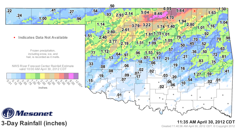
The Blackwell Mesonet site led the way with 8.46 inches of rainfall, but the
surrounding Mesonet sites as well as the radar-estimated contours show widespread
5-8 inch amounts from that part of the state, as well as a broader area of 2-4
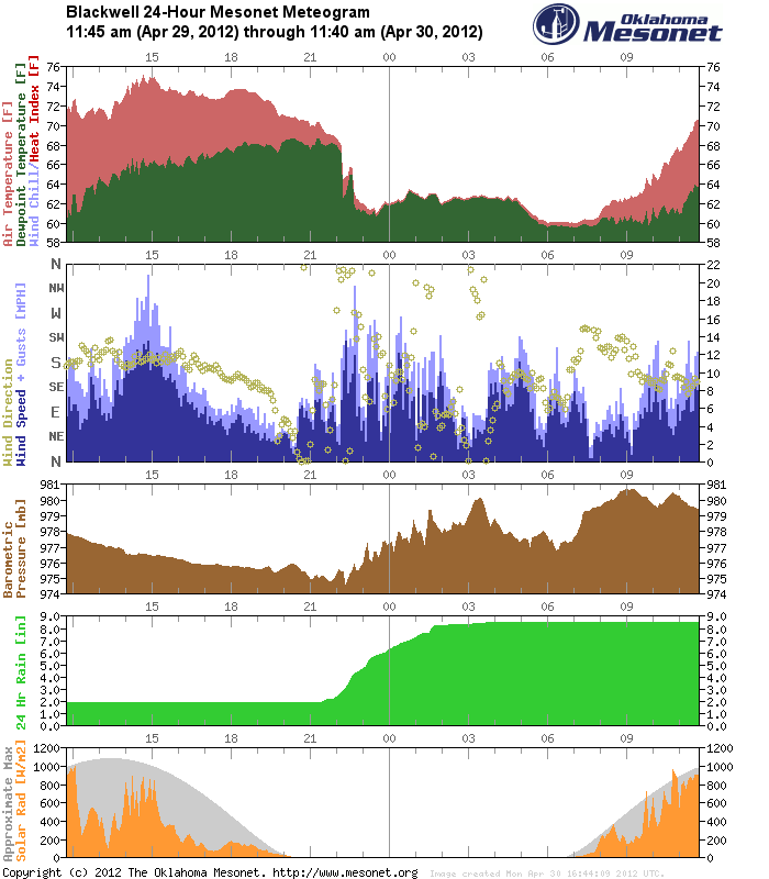
inches radiating outward. The 24-hour meteogram from the Blackwell Mesonet site
tells us that over 6.59 inches of that 8.46 fell in the last 24 hours, and that
6.59 inches all fell between 9:15 p.m.-4:00 a.m. To narrow it down even farther,
6.31 inches of that 6.59 inches fell at Blackwell between 9:15 p.m.-1:45 a.m.,
a span of just 4.5 hours!
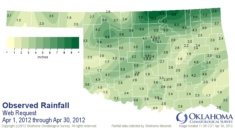
With another 11 hours or so to go, that brings Blackwell's April total rainfall
up to 10.2 inches. Much of Grant, Kay and Osage counties have totals ranging
from 7-10 inches.
That Mesonet total would become the wettest April on record for Blackwell,
comparing it to both the Mesonet and COOP historical totals. The COOP record
goes back to 1953 and the Mesonet record dates to 1994. Here are the top-10
wettest Aprils on record for Blackwell according to the longer-term COOP
record.
-****-
1991 8.59
1999 7.68
1994 7.57
1988 7.56
1976 7.08
-***-
The Ponca City Airport recorded 9.16 inches of rain over the last couple of
days with more than 6 inches of it falling between 9 p.m.-1 a.m. last night.
That is going to bring Ponca City's total close to 10 inches for the month,
which would in turn be their wettest April on record. The previous wettest
April on record for Ponca City was 1994's 9.66 inches. The Ponca City Airport
records date back to 1948, although there are records from another Ponca City
station that dates back to 1893. That station recorded 8.39 inches back in
April 1897.
Remember, this area still has a chance of rain later today, so these
record-setting numbers could still increase. For those wondering, these April
totals are a far cry from the record totals for any month at these locations.
Ponca City's June 1957 total of 14.01 inches tops their totals while Blackwell's
July 1959 total of 13.57 inches tops their list. Blackwell's June 1957 total
was 12.53 inches.
While the northern third of the state has been ordering blueprints from Noah,
other parts of the state are still waiting for their April showers. The
southeastern half of the state has generally been left out, with I-44 being
a demarcation line between the have-too-much(es) and the have-nots.
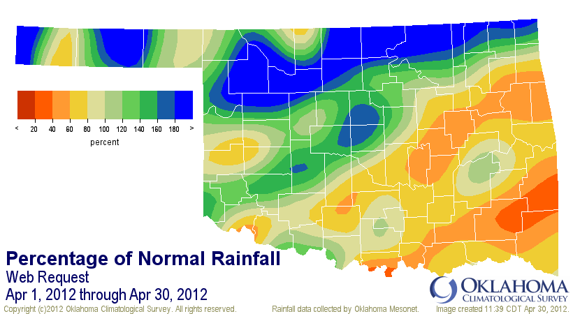
As it stands now, as of about 1:30 p.m. on April 30 with more rain still
possible, the statewide average rainfall total for the month is 3.61 inches,
or about a third of an inch above normal. So those generous totals up north
are fairly well off-set by the lack of rain in the southeast. That will
probably place the month in possibly the top-40 wettest Aprils on record,
dating back to 1895, but there are plenty of nuances there. North central
Oklahoma is already the eighth wettest (again, still could go up tonight) while
the southeast currently stands as the 18th driest with an average of 2.51 inches
(about 2 inches below normal).
For a sneak peak at the final April temperatures, yeah, it's going to come up
hot. The month will be one of the 12 warmest Aprils on record at around 5
degrees above normal statewide. And easily the warmest January-April (year-to-
date) and March-April (spring-to-date) periods on record.
We'll have final numbers tomorrow.
One final jaw-dropping April statistic ... of the 120 Oklahoma Mesonet stations,
only two reached the freezing mark. Boise City (April 16) and Beaver (April 8)
both reached 32 degrees for less than an hour for the month. Other than that,
none of the Mesonet stations reached freezing.
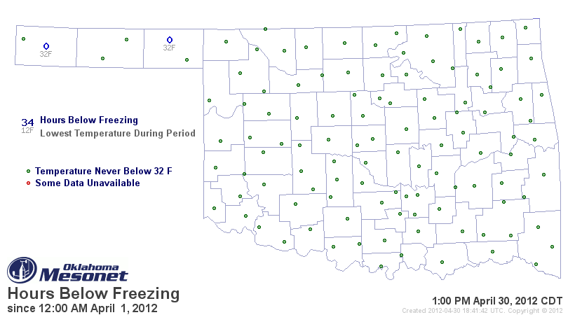
The only freezing temperatures I can find thus far from the COOP network
are 30 degrees from Goodwell and 32 degrees from Beaver.
So much for that worry of an April freeze!
Gary McManus
Associate State Climatologist
Oklahoma Climatological Survey
(405) 325-2253
gmcmanus@mesonet.org
April 30 in Mesonet History
| Record | Value | Station | Year |
|---|---|---|---|
| Maximum Temperature | 96°F | BEAV | 2013 |
| Minimum Temperature | 26°F | EVAX | 2017 |
| Maximum Rainfall | 6.12 inches | NOWA | 2019 |
Mesonet records begin in 1994.
Search by Date
If you're a bit off, don't worry, because just like horseshoes, “almost” counts on the Ticker website!