Ticker for April 5, 2012
MESONET TICKER ... MESONET TICKER ... MESONET TICKER ... MESONET TICKER ...
April 5, 2012 April 5, 2012 April 5, 2012 April 5, 2012
Lessons from 2011: Tornadoes and summer heat
Tornadoes
This is our standard cautionary tale we send out each year about tornadoes, but
with the storms recently that struck the DFW area, it bears repeating. The
possibility of flying tractor-trailers (always been my favorite screen-saver!)
is but a storm system away at all times.
At this time last year, Oklahoma's 2011 total of 119 tornadoes was nothing but
a gleam in Mother Nature's eye. We'd had one already in late February, a puny
EF0 twister barely within the state's boundaries in Osage County. Through April
13, that's where the count stayed. After the 14th, however, that count had
risen to 34, and by the end of April the total stood at 51. The 50 tornadoes in
April last year were easily the most during that month since accurate statistics
began in 1950. The previous high was 40 tornadoes back in 1957. Another oddity
about those tornadoes is that they all occurred east of I35. During that time
frame, drought was really beginning to intensify in the western half of the
state.
An above average (21.7) May total of 46 tornadoes kicked the total up to 97,
a mark already close to twice the annual average of 55. By the end of 2011, the
total stood at 119 tornadoes, the second most in history. The top spot is still
held by the remarkable 1999 with 154.
Added caution: Oklahoma only had three tornadoes through April in 2010 and ended
up with 102.
So what does it mean that we've only had a preliminary count of five twisters?
Not a darn thing, other than that's just about average for the first three
months of the year.
*************************************
Warmest March on record...what's it mean for Summer??
Much like the Bananarama song from the 1980s, last year's Cruel Summer is
undoubtedly etched in our minds, still awaiting an exorcism. The number of
times I've been answering the question, "Does this March-that-seems-like-May
mean a hot summer?" shows this to be true. Well, the answer to the question is
"no." That doesn't mean we won't have a hot summer, of course. Those are always
on standby for Mother Nature behind the "break glass to mess with Oklahoma"
sign. But there are other things at play here more important than what happens
prior to summer. Now what happens prior to summer can help decide the
difference between a hot summer and a HOT summer, but the real determination
still lies within the season itself. Let me explain.
Summer heat is very negatively correlated with precipitation from month-to-
month. In other words, if it rains a lot, we have mild summer temperatures.
Conversely, if it doesn't rain much, we have a hot summer. And it really only
holds true for the summer months of June-August. You can "sort of" see that for
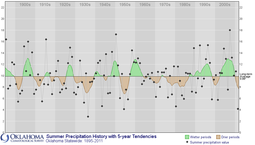
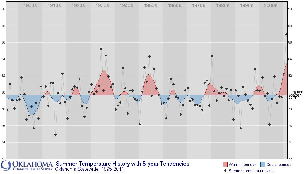
yourself looking at the summer time-series of Oklahoma statewide average
precipitation and temperature, 1895-2011. In general, the brown (dry) years on
the precip graph match up with the red (hot) years on the temperature graph,
and the greens (wet) match up with the blues (mild).
Former entire Ticker Staff Deke Arndt displayed more definitive proof in a
previous Ticker, demonstrated in his graphic.
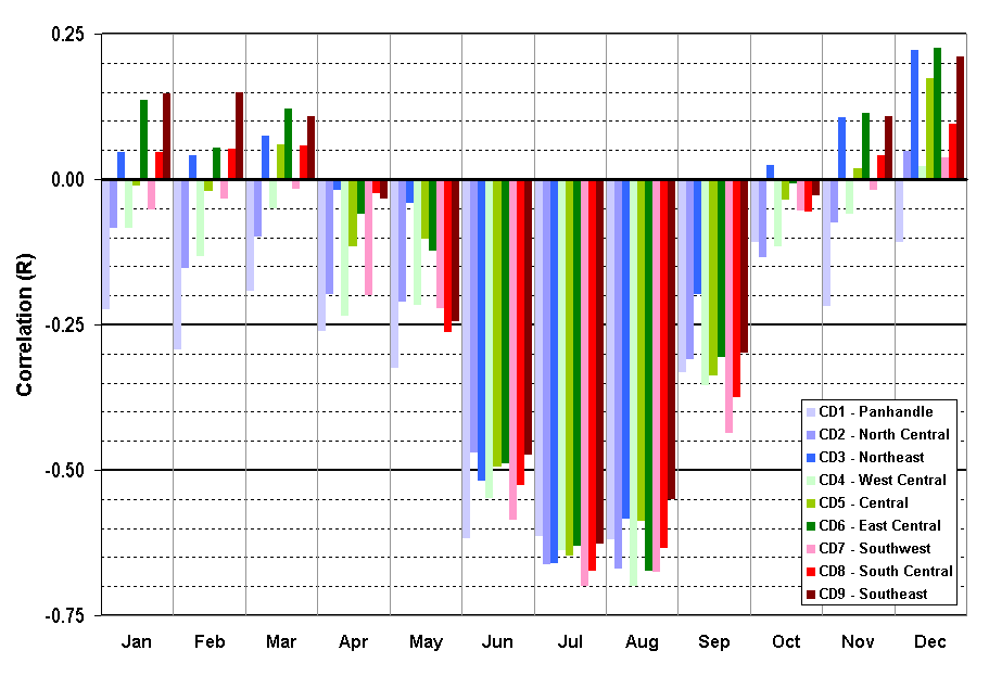
The more negative the number you see in that graph, shown for each of the nine
Oklahoma climate divisions, the stronger the negative correlation. The
explanation is pretty simple when you boil it down to the root cause. The
energy (ultraviolet) received by the sun is at a maximum in the summer. Some of
that energy is used to evaporate soil moisture or in the photosynthesis process
in plants. Both of those are cooling mechanisms. The rest of the energy is
absorbed by the surface and converted into heat (infrared) energy. That's why
it feels cooler over a nice green vegetative surface than over bare dirt or
concrete. The drought took away those cooling mechanisms last summer. Not only
that, another cooling mechanism was also in short supply - clouds, and that
makes sense. A lack of cloudiness would seemingly go hand-in-hand with extreme
drought. For an extreme summer, at some point it helps to get a land-atmosphere
feedback loop set up (more on that at the bottom). Simply stated, that's how
our hot summer became a hot summer on steroids.
So with as green as it is, and as saturated as the soils are now, we have a
hope that with further springtime rains, we'll enter summer sitting pretty.
After that, summer temperatures are by and large controlled by precipitation
amounts (which comes with clouds, green vegetation, and soil moisture). In
other words ... we won't know until we get there.
This is Oklahoma, however, and it could not rain again for another two months
and nobody would be shocked. One thing to watch for is drought relief to our
southwest. The eastern half of the state was completely out of drought last
May. All it took to plunge it back into the depths of drought was about a month
of hot, dry winds blowing up from the dessicated areas of southwestern
Oklahoma and west Texas.
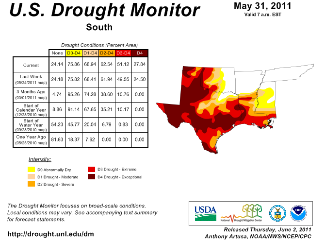
May 31, 2011 Southern Plains Drought Picture
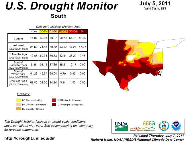
July 5, 2011 Southern Plains Drought Picture
******************************************
Here's a more detailed explanation ... wade in at your own risk!
Last year's hot summer became extreme thanks to the persistent ridge of high
pressure that camped over the Southern Plains, the presence of one of the most
intense short-term (relatively) droughts in state history, and the resulting
land-atmosphere feedbacks that intensified both. Here's how it works: entering
summer in drought with all it's inglorious impacts (dormant and dead vegetation
and dessicated soils) allows the sun's rays(ultraviolet energy) at their most
intense to get converted almost entirely to heat energy (infrared). By baking
the soil, that evaporates more soil moisture, which increases the ability of
the sun's rays to heat the surface, which leeches out MORE soil moisture ...
etc., etc., and so on and so forth. Eventually you have completely dessicated
soils and a majority of the sun's rays are thusly being converted to heat
energy. Add to that the loss of more plants due to the combination of
heat/drought and you have fewer green plants using the sun's rays in
photosynthesis. The resulting heat then strengthens the heat dome over the
area, which strengthens the drought, which strengthens the heat, etc. That's
the land-atmosphere feedback, or steroids, that gave our state the hottest
summer on record, for any state for any year.
Gary McManus
Associate State Climatologist
Oklahoma Climatological Survey
(405) 325-2253
gmcmanus@mesonet.org
April 5 in Mesonet History
| Record | Value | Station | Year |
|---|---|---|---|
| Maximum Temperature | 95°F | TIPT | 2022 |
| Minimum Temperature | 21°F | EVAX | 2023 |
| Maximum Rainfall | 2.95 inches | CLOU | 2025 |
Mesonet records begin in 1994.
Search by Date
If you're a bit off, don't worry, because just like horseshoes, “almost” counts on the Ticker website!