Ticker for January 25, 2012
MESONET TICKER ... MESONET TICKER ... MESONET TICKER ... MESONET TICKER ...
January 25, 2012   January 25, 2012   January 25, 2012   January 25, 2012


Heavy rains envelop Oklahoma

The long-promised storm system finally moved into Texas yesterday and generated
showers and storms through the overnight hours in Oklahoma. And rain is still
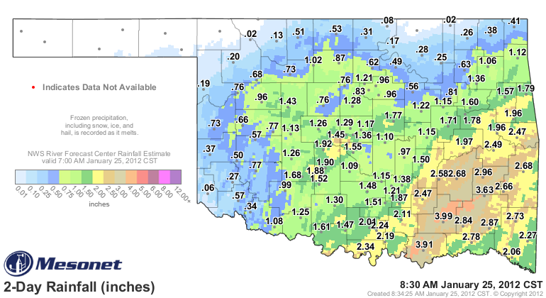
falling in southeastern Oklahoma. The Oklahoma Mesonet indicates the heaviest
rain fell from Bryan County up through Pittsburg, Latimer and LeFlore Counties.


The Oklahoma Mesonet site at Lane led the state with 4 inches (and counting), and
the radar estimated overlay shows a good area of 4-5 inches in Atoka and
Pushmataha Counties. Durant had 3.91 inches with more on the way. Widespread
rains of 2-3 inches inundated the southeastern quarter of the state. Amounts
dropped off farther to the north and west, but 1-2 inch amounts were common up
into northwestern Oklahoma. Unfortunately, far western and northern Oklahoma were
once again left out of the festivities. However, all but 17 of the Oklahoma
Mesonet's 120 stations received at least a quarter of an inch of rain. Oklahoma
City Will Rogers Airport recorded 1.52 inches yesterday, breaking the old record
total of 0.37 inches for January 24th set in 1949. Oklahoma City's two-day total
is now up to 2.23 inches.

Here are the top 20 rainfall totals as recorded by the Oklahoma Mesonet.

-****-
Lane	        4.01"		Talihina	    2.66"
Durant	        3.94"		Stuart	            2.59"
Clayton	        3.64"		Centrahoma	    2.49"
Wilburton       2.96"		Stigler	            2.49"
Cloudy	        2.87"		Sallisaw	    2.48"
Antlers	        2.84"		Burneyville	    2.35"
Hugo	        2.79"		Broken Bow	    2.28"
Mt Herman       2.76"		Ardmore	            2.25"
McAlester	2.69"		Madill	            2.20"
Wister	        2.68"		Tishomingo	    2.13"
-***-

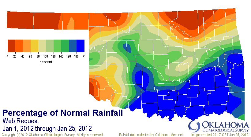
The latest rain brings the statewide average for the month up to 1.6", 0.41"
above normal and the 22nd wettest first 25 days of January since 1921. That
average is deeply slanted towards the heavy rains in the southeast, however.
There are still parts of northwestern, northern and southwestern Oklahoma
that need a good dose of rain of their own.


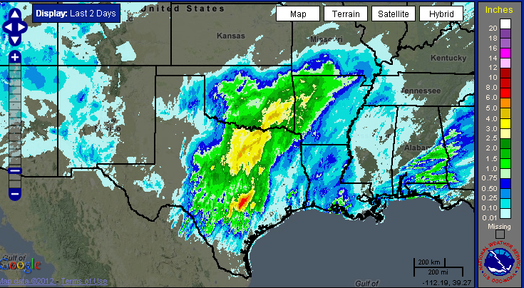
The drought stricken Southern Plains got a nice and satisfying drink of water
with this storm from south Texas up through Arkansas. Central Texas had a
large area of 6-8 inches.


Finally, a warning about tomorrow's release of the U.S. Drought Monitor map ...
it won't reflect this latest rainfall event. The cutoff time for precipitation
to consider each week is 6 a.m. on Tuesday mornings. We sometimes stretch that
envelope, but probably a bit too late to make widespread changes.

Gary McManus
Associate State Climatologist
Oklahoma Climatological Survey
(405) 325-2253
gmcmanus@mesonet.org
January 25 in Mesonet History
| Record | Value | Station | Year |
|---|---|---|---|
| Maximum Temperature | 77°F | MADI | 2005 |
| Minimum Temperature | 7°F | VINI | 2019 |
| Maximum Rainfall | 3.32″ | MTHE | 2012 |
Mesonet records begin in 1994.
Search by Date
If you're a bit off, don't worry, because just like horseshoes, “almost” counts on the Ticker website!