Ticker for January 19, 2012
MESONET TICKER ... MESONET TICKER ... MESONET TICKER ... MESONET TICKER ...
January 19, 2012 January 19, 2012 January 19, 2012 January 19, 2012
South central Oklahoma wins the drought sweepstakes this week
The 1-2 inches of rain that the eastern half of southern Oklahoma (hey, it works)
received nine days ago was enough to finally propel the area out of moderate
drought to the more benign "abnormally dry" category.
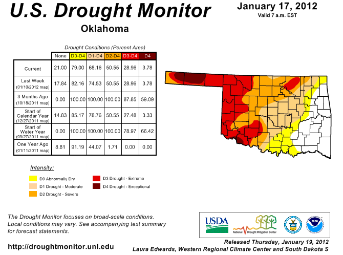
That drops the percentage of state in drought from 75% to 68%. Three months ago
100% of the state was considered to be in some stage of drought severity. The
Drought Monitor of one year ago had 44% of the state in drought but only 2%
was in the severe-exceptional categories. The latest drought map has 51% of the
state in the severe-exceptional categories.
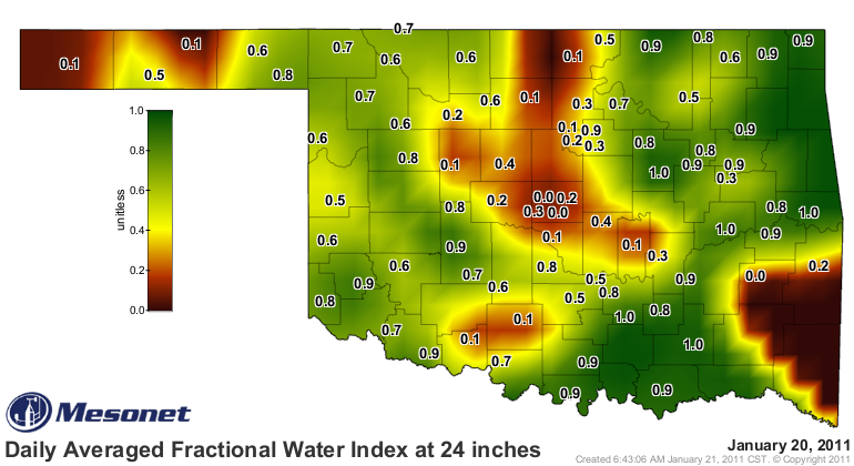
In some aspects, mostly in the short-term impacts, Oklahoma is better off than
last year. This 24-inch depth soil moisture map from last year at this time shows
decent conditions over much of the state, but there was significant dryness in
central, north central and southeastern sections of the state, as well as the
western half of the Panhandle.
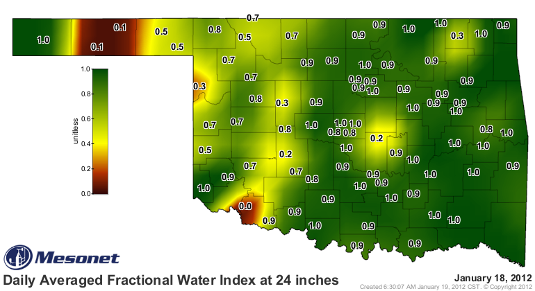
Compare that with today's 24-inch soil moisture map and you can see most of
the state has fairly good moisture at that depth.
Now, we have started to dry out once again. This map of consecutive days with
less than 0.25 inches of rain in a single day indicates that it has now been
about a month since the northwestern half of the state has received significant
moisture.

Once again, not a reason to panic. Evapotranspiration demands are extremely
low this time of year thanks to cooler temperatures and dormant vegetation.
Imagine that map in July and you would have a whole mess of trouble. Wait, we
DID have that map in July and we DID have a whole mess of trouble. It does
illustrate the importance of the part of the calender you're in, however.
Take a look at the rainfall map for the last 30 days and then the percent of
normal map for the same period.
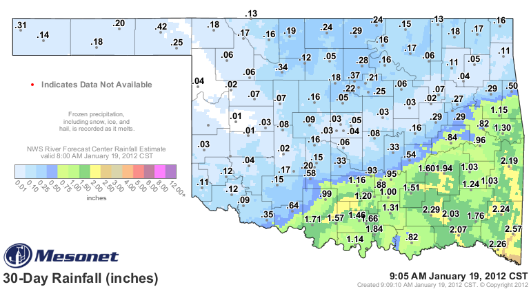
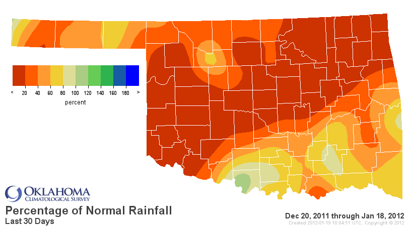
YIKES!! Looks fairly serious, right? Well, let's add some context. As we've
mentioned before, normal precipitation amounts in January are not much to write
home about. Check out the normal map and then the departure from normal map
to get the mentioned context.

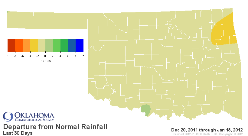
That's not to say that a good dose of moisture would be unwelcome, especially for
western Oklahoma. But the moisture that did fall from October-December will
stick around in the soils and reservoirs for the most part until we start to
warm up again. That's one case where the possible warmer than normal weather
will work against us a bit.
The latest outlooks from the National Weather Service's Climate Prediction
Center indicate increased probabilities for warmer than normal weather, both
in the February and February-April periods. The precipitation outlooks are a
bit more nondescript with the dreaded "equal chances" (i.e., punt)for the
state during February and increased odds of below normal precipitation in the
western half of the state for the February-April period.
February Outlooks


February-April Outlooks
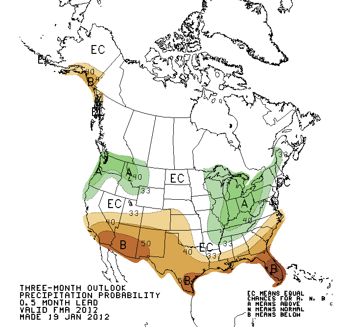

Those outlooks spell continuing drought for the western half of the state,
according to the forecasters at the CPC.

The yellow "drought development likely" tag has returned to the state on this
map for the first time in a long while. That's the area that was just taken
out of drought on the current Drought Monitor map. There is an area of "some
improvement" up in northeastern Oklahoma, however. Quoting the CPC forecaster
Dave Miskus on the reasoning for our area:
"... dry weather has returned to the southern Plains since Christmas.
With high odds for above-normal temperatures (1- and 3-month outlooks)
and subnormal precipitation (e.g. La Ni?a composites and precipitation
tools), persistence is favored across much of the southern Plains, with
development in Texas areas currently without drought. However, some
improvement is forecast across southeast Kansas and the Arklatex region
where the CPC seasonal outlook indicates equal chances for below, near,
or above precipitation and the 6-10 and 8-14 day outlook indicates
enhanced odds for above median precipitation.
Forecast confidence for the southern High Plains is high, and moderate
for areas to the east (e.g. southeast Kansas, eastern Oklahoma, and
eastern Texas)."
So it looks a bit like persistence of our current weather for the near future.
Dry weather in western Oklahoma, chances of some rain in eastern Oklahoma and
generally warm in the state with a few cold fronts from time-to-time.
Always important to remember that at this time last year, we had no clue what
we were in store for during the last few days of January and the first couple
of weeks of February. And the rest of the year for that matter.
Gary McManus
Associate State Climatologist
Oklahoma Climatological Survey
(405) 325-2253
gmcmanus@meosnet.org
January 19 in Mesonet History
| Record | Value | Station | Year |
|---|---|---|---|
| Maximum Temperature | 77°F | BURN | 1999 |
| Minimum Temperature | -4°F | BOIS | 2025 |
| Maximum Rainfall | 0.66 inches | COOK | 2019 |
Mesonet records begin in 1994.
Search by Date
If you're a bit off, don't worry, because just like horseshoes, “almost” counts on the Ticker website!