Ticker for December 14, 2011
MESONET TICKER ... MESONET TICKER ... MESONET TICKER ... MESONET TICKER ...
December 14, 2011 December 14, 2011 December 14, 2011 December 14, 2011
The weather outside is not even remotely frightful
If you got up this morning thinking it felt more like early spring than mid-
December, that's because it feels more like early spring than mid-December. You
are welcome. Glad to help, that's why I'm here. All skidding aside (that comes
later), much of the state managed to remain in the 50s overnight, as is evident
on the low temperature map from the Oklahoma Mesonet.
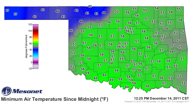
That's fairly abnormal for this time of year, and I'm somebody that knows
abnormal. The proof is in the record high minimum temperature map for this date,
with data going back to the late 1800s.
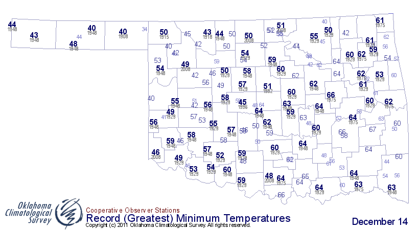
So comparing the two maps, it's evident that some places have managed to top their
record warm low temperatures thus far today, thanks mainly to a surge of warm
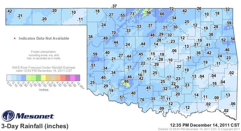
moist air from the south. That is also giving us our gray skies and drizzly
weather. Amounts have been mostly insignificant, but when we consider this
is December, that description turns to somewhat significant.
Will it last? There is a cold front that will be making its way through the
state later today, according to our friends at the Norman and Tulsa NWS
forecast offices.
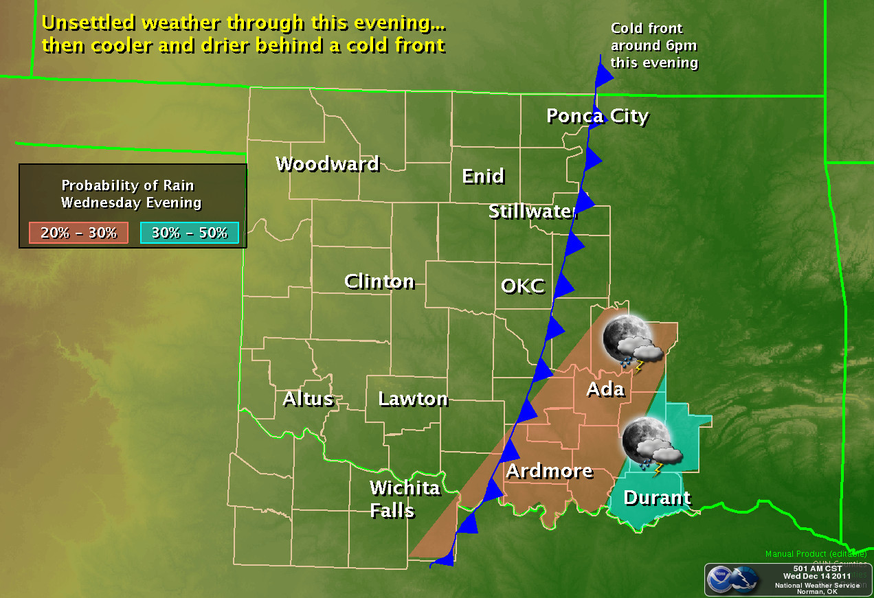
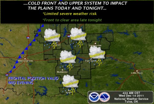
So even though our morning lows were in record warm territory, that probably
won't be the historical memory when the final low temperatures for the day
are recorded. Remember, the Oklahoma Mesonet and some NWS sites measure their
daily data midnight-midnight. If the front drops temperatures into the 40s
by midnight, that will be the official low for the day.
For those NWS COOP sites that take their measurements at 6 p.m. or something
similar, they might have a chance to list a record for the day. Their low
temperature readings might still be from this morning if the front doesn't
arrive by 6 p.m. But that comes with its own problems. If the front isn't
through those areas by the time they go out and read the max-min thermometer,
then a high temperature set right before the front arrives could bleed into
tomorrow's data.
Confused yet? Here's an example. Suppose an observer goes out to check the data
everyday at 6 p.m. And suppose the front isn't through their area until 8 p.m.
If the maximum reading on the thermometer at 6 p.m. is 63 degrees, that will be
recorded as the high for December 14. So they reset the thermometer. Since the
front isn't through yet, the thermometer zooms back up to, say 61 degrees. Then
the front comes through at 8 p.m. and drops temperatures into the 40s. Now when
the observer goes out to read the thermometer at 6 p.m. tomorrow, that 61
degrees will be the official high temperature for the December 15, even though
it occurred between 8 p.m. and midnight on the 14th. Instruments on the Mesonet
and ASOS and other automated stations will have their high temperatures for
the 15th recorded midnight-midnight, however. Probably in the 40s or low 50s.
And there is a whole other set of complications with observers that check at
6 a.m. On days with something like a front or another game-changer, it can cause
a time-shift bias on the observations. And those types of biases exist
throughout the historical record.
I may have just given you a Rubick's Cube as you try and puzzle through the
oddities of time-of-observation bias, but hey, that beats a sweater. And
nothing can change the fact that it was unusually warm outside when you woke up
this morning. But this is also a fact that will probably be lost in memory ...
and the data.
Gary McManus
Associate State Climatologist
Oklahoma Climatological Survey
(405) 325-2253
gmcmanus@mesonet.org
December 14 in Mesonet History
| Record | Value | Station | Year |
|---|---|---|---|
| Maximum Temperature | 83°F | ARNE | 2021 |
| Minimum Temperature | -3°F | MEDF | 2000 |
| Maximum Rainfall | 2.69 inches | SLAP | 2023 |
Mesonet records begin in 1994.
Search by Date
If you're a bit off, don't worry, because just like horseshoes, “almost” counts on the Ticker website!