Ticker for October 18, 2011
MESONET TICKER ... MESONET TICKER ... MESONET TICKER ... MESONET TICKER ...
October 18, 2011 October 18, 2011 October 18, 2011 October 18, 2011
Wind chills dip below freezing in the Panhandle
Yesterday's cold front left Oklahoma with some of its coldest weather of the
season this morning.
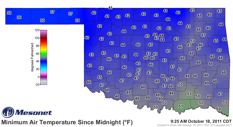
The strong winds overnight no doubt helped keep the air mixed a bit and prevented
the temperatures from plummeting further from the Mesonet low of 36 degrees last
night. That doesn't match the 35 degrees Kenton on the 13th and at Nowata on the
second. But when you add the winds, the wind chills make it the coldest morning
seen in the state since last May. Wind chills dropped to below freezing up
in the Panhandle with 28 degrees calculated at Boise City and Goodwell.
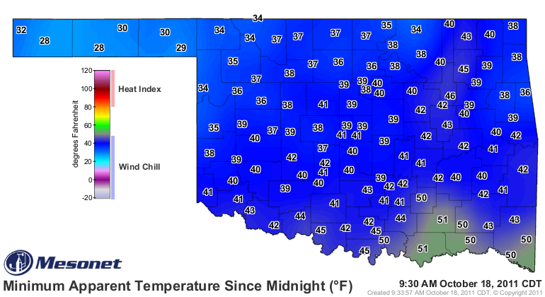
That's the lowest wind chill recorded by the Mesonet's 120 stations since Boise
City blew in at 27 degrees last May 15th. The front also kicked off severe storms
in eastern Oklahoma. Better yet were the rainfall totals of more than an inch
scattered about in southeastern Oklahoma. A drop in the bucket compared to
their deficits over the last year or so, but welcome nonetheless.

Temperatures are expected to continue their nighttime decline over the next
few days. Freezing temperatures in northern Oklahoma are possible as we go
through the rest of the week.
Gary McManus
Associate State Climatologist
Oklahoma Climatological Survey
(405) 325-2253
gmcmanus@mesonet.org
October 18 in Mesonet History
| Record | Value | Station | Year |
|---|---|---|---|
| Maximum Temperature | 96°F | WEBB | 2005 |
| Minimum Temperature | 22°F | NOWA | 2022 |
| Maximum Rainfall | 2.10 inches | IDAB | 2002 |
Mesonet records begin in 1994.
Search by Date
If you're a bit off, don't worry, because just like horseshoes, “almost” counts on the Ticker website!