Ticker for October 10, 2011
MESONET TICKER ... MESONET TICKER ... MESONET TICKER ... MESONET TICKER ...
October 10, 2011   October 10, 2011   October 10, 2011   October 10, 2011


Finally!

Mother Nature served up a wheat crop-saving rainfall over the weekend. While
not everybody received plentiful moisture, much of western and central Oklahoma
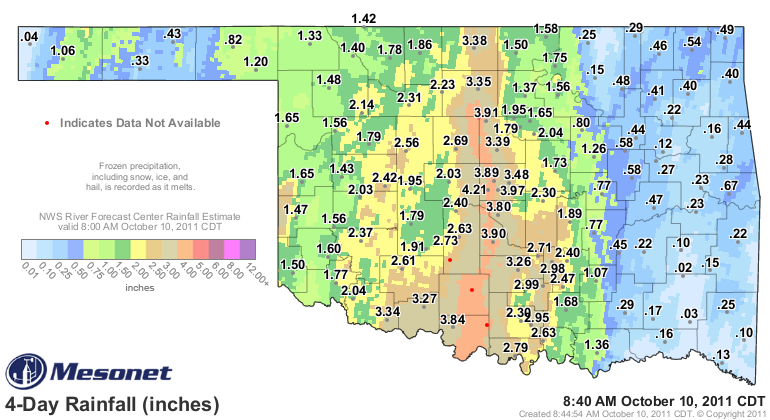
did with 2"-5" of a nice soaking rainfall. This map from the Oklahoma Mesonet
and radar overlay from the NWS' RFC shows the results of the wayward upper-level
low pressure system that kicked the Gulf moisture back into play.


The official winning rainfall total came from Ringling with 4.32 inches,
although you can see from the radar estimates that there were obviously
localized areas that received a bit more than that. A broad swatch of 3"-5"
totals show up from eastern Tillman County to the I-35 corridor, the Red River
to the Kansas border. Totals fall off quite rapidly once you get to farther to
the east. Far western Oklahoma and the Panhandle received welcome moisture,
although not quite to the degree that central Oklahoma did.

Of the 120 Oklahoma Mesonet stations, 43 received more than 2" of rainfall. Here
are the top-20 totals as measured by the Mesonet rain gauges.

Ringling	    4.32"	Medford	            3.46"
OKC West	    4.21"	Breckinridge	    3.43"
Ketchum Ranch	    4.13"	Guthrie	            3.39"
Marshall	    4.01"	Grandfield	    3.36"
OKC East	    3.97"	Walters	            3.28"
Washington	    3.90"	Pauls Valley	    3.26"
OKC North	    3.89"	Sulphur	            2.99"
Waurika	            3.84"	Vanoss	            2.98"
Norman	            3.80"	Ardmore	            2.96"
Spencer	            3.48"	Burneyville	    2.80"

Unfortunately there were 57 stations that received less than 1.5" for the event.
Here are the bottom-10 totals.

Tahlequah	    0.16"
Talihina	    0.15"
Wynona	            0.15"
Idabel	            0.13"
Porter	            0.12"
Wilburton	    0.10"
Broken Bow	    0.10"
Kenton	            0.04"
Cloudy	            0.03"
Clayton	            0.02"

The Panhandle went from flash flood watches on Friday to less than in inch of
rainfall, in general, so an unfortunate turn of events for those folks.

Obviously we will be tallying the rains and looking for impact reports as we
communicate with the U.S. Drought Monitor author for this week. This rainfall
event was not a drought ender, but for parts of the state it was definitely a
drought reliever. The rains that soaked into the soils are a welcome deposit
to the state's water bank. That moisture will be available for crops to use
if dry weather continues through the fall and winter months. At least to the
degree that the soil moisture was replenished and remains available. And
remember that this rain fell into October weather, not the triple-digits of
July or August. The demands on this water are light years less than what occurs
during the warm months.

Now we need more. Keep in mind that those parts that saw relief will probably
still be in D3 (extreme) drought on the Drought Monitor. The statewide average
rainfall total for the year went from 15.93" through Thursday, 13.04" below
normal, to 17.45" through today, 11.96" below normal. The driest year on record
statewide is 19.04" in 1910.

But for those folks that had worked ground waiting to plant their winter wheat
crop, or had already planted and were waiting for moisture, this probably saves
their crop and hopefully propels it to a great crop.

Gary McManus
Associate State Climatologist
Oklahoma Climatological Survey
(405) 325-2253
gmcmanus@mesonet.org
October 10 in Mesonet History
| Record | Value | Station | Year |
|---|---|---|---|
| Maximum Temperature | 97°F | GRA2 | 2024 |
| Minimum Temperature | 21°F | BRIS | 2000 |
| Maximum Rainfall | 4.52 inches | ANTL | 2004 |
Mesonet records begin in 1994.
Search by Date
If you're a bit off, don't worry, because just like horseshoes, “almost” counts on the Ticker website!