Ticker for September 12, 2011
MESONET TICKER ... MESONET TICKER ... MESONET TICKER ... MESONET TICKER ...
September 12, 2011 September 12, 2011 September 12, 2011 September 12, 2011


100 100s (and tornadoes! Remember them?)

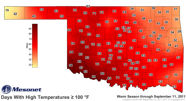
Grandfield made it official today, putting the cherry on top of the "days at or
above 100 degrees" record for Oklahoma at an even, well ... 100. Just another of
the extremes we've seen this summer and year. Recall that the previous record was
86 days from Hollis in 1956. Not only has Grandfield utterly destroyed that
record this year, other southwestern Oklahoma towns Altus, Hollis, Mangum, and
Tipton have exceeded that 86 days mark (and Walters is on the verge).


Be sure to check back tomorrow for the updated map of triple-digit triple digits.
(Important note: Altus has two missing days of data in which Grandfield reached
100 degrees.)

http://www.mesonet.org/index.php/weather/map/days_with_highs_above_100f/air_temperature

And this is all after playing with one September tied behind its back. Since
September 4th's strong cold front scoured our state of the heat, Oklahoma's
statewide average temperature has been 68.8 degrees (highs and lows together and
divided by 2), 6.5 degrees below normal. And it has been the low temperatures
that have made the bulk of that difference. Low temperatures averaged 53.5 degrees
since September 4th, 9.5 degrees below normal. Over that same period, the highs
have averaged 84.1 degrees, only 3.5 degrees below normal.

Compare that 68.8-degree average to the summer statewide average of 86.8 degrees
as measured by the Oklahoma Mesonet. Quite a change we've had. Too bad it didn't
extend to precipitation.

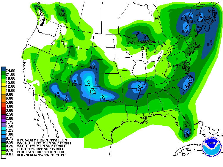
Speaking of rainfall, we've been promised some lovely wet, gray days during this
week. The Hydrometeorological Prediction Center shows a 5-day precipitation
forecast of greater than in inch in southwestern Oklahoma. This is something
concrete to hope for.


#######################

2011 Oklahoma tornado count now third highest on record

According to preliminary statistics from Oklahoma tornado guru Doug Speheger,
Oklahoma has now had 103 tornadoes in 2011. Doug is very meticulous about
confirming these tornadoes, so I think the number is pretty solid. The 103
twisters in 2011 would move the year past LAST year's tornado count of 102.
The deadly EF2 tornado that destroyed three mobile homes near Locust Grove on
August 10 pushed us over the top. 2011 would rank third behind 1999's 145
tornadoes and 1957's 107. Accurate tornado statistics begin in 1950. Here's
your top 10.

Year           Total
--------------------
1999		145
1957		107
2011		103
2010		102
1982		101
1960		 98
1983		 92
1998		 83
1961		 82
1995	 	 79

As you may recall, the 50 tornadoes in Oklahoma during April was a record for
that month, and May was no slouch with 46. June had 5 and February and August
had one apiece to make the total 103.

Blizzards, ice storms, drought, heat, hail ... I'm almost scared to see what
Mother Nature has for us next. Here's an idea: how about record-setting boredom!

Gary McManus
Associate State Climatologist
Oklahoma Climatological Survey
(405) 325-2253
gmcmanus@mesonet.org
us over the top. There was one fatality associated with that tornado.
September 12 in Mesonet History
| Record | Value | Station | Year |
|---|---|---|---|
| Maximum Temperature | 105°F | ALTU | 2011 |
| Minimum Temperature | 40°F | BOIS | 2014 |
| Maximum Rainfall | 9.13 inches | FAIR | 2008 |
Mesonet records begin in 1994.
Search by Date
If you're a bit off, don't worry, because just like horseshoes, “almost” counts on the Ticker website!