Ticker for August 22, 2011
TICKER UPDATE: Oklahoma City breaks its all-time 100-degree day record
Add Oklahoma City to the list of locations setting records for 100-degree days.
With their 51st 100-degree day today, Oklahoma City surpasses its previous
record of 50 days, set back in the relentless summer heatwave of 1980.
Oklahoma City reached 100 degrees for the first time this year on June 14. Its
average temperature for the summer (June 1-August 21) thus far is 87.1 degrees,
5.9 degrees above normal. Its average high of 100.3 degrees is 8.4 degrees
above normal. In the 83 days since June 1, the high temperature has been above
normal on all but four days (through today). The highest temperature reached
was 110 degrees on July 9 and August 5 and 6.
The hottest summers on record (dating back to 1891) for Oklahoma City were the
summers of 1934 and 1980, each with an average temperature of 85.9 degrees.
This summer will obviously eclipse that mark.
In the previous record year of 1980, the first 100-degree day was June 25 and
the last occurred on August 30. Temperatures rose into the 90s 19 times
during September and three times in October.
Gary McManus
Associate State Climatologist
Oklahoma Climatological Survey
(405) 325-2253
gmcmanus@mesonet.org
MESONET TICKER ... MESONET TICKER ... MESONET TICKER ... MESONET TICKER ...
August 22, 2011 August 22, 2011 August 22, 2011 August 22, 2011
Grandfield breaks Oklahoma's number of 100-degree days record
Shortly after noon, the Oklahoma Mesonet site at Grandfield reached 100 degrees
for the 87th time in 2011, eclipsing the state's record for number of days at
or above 100 degrees. The previous record of 86 days was held by Hollis from the
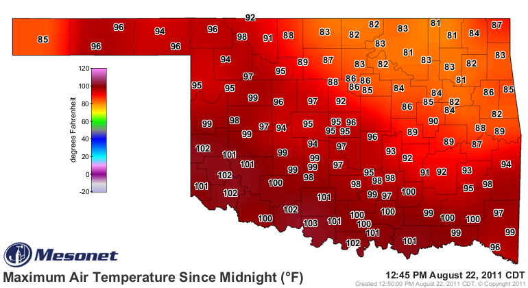
summer of 1956. Here is the maximum temperature map from the Oklahoma Mesonet
through 12:45 pm.
You can keep track of today's maximum temperatures here:
http://www.mesonet.org/index.php/weather/map/todays_maximum_temps/air_temperature
and the number of 100-degree days for each Mesonet site (updated each following
day) here:
http://www.mesonet.org/index.php/weather/map/days_with_highs_above_100f/air_temperature
Grandfield's first triple-digit reading was 101 degrees back on April 18. In
fact, since June 1 there have only been five days that Grandfield didn't
see a 100-degree temperature.
Month # of 100-degree days
April 1
May 8
June 28
July 31
August (1-22) 19
Altus also added another 100-degree day to their tally to stand at 85 days.
Here is an updated list of the top 100-degree day counts across the state since
records began in the late 1880s.
Historical 100-degree days in a year
GRANDFIELD - 87 days in 2011
HOLLIS - 86 days in 1956
ALTUS - 85 days in 2011
HEALDTON - 83 days in 1980
WALTERS - 83 days in 1998
HOLLIS - 82 days in 2011
CHATTANOOGA - 82 days in 1998
WOODWARD - 81 days in 1896
HOLLIS - 81 days in 1952
HOLLIS - 81 days in 1939
FREDERICK - 81 days in 1954
Grandfield's average summer temperature (climatological summer runs from June 1
through August 31) through August 21 has been 92 degrees, with an average high
temperature of 106 degrees. Since October 1, 2010, Grandfield has seen 5.9
inches of rainfall, nearly 20 inches below normal.
Grandfield is not only going to break the record for 100-degree days, it's
going to smash it. The forecast high temperatures for the next 6 days are 106,
105, 104, 103, 104 and 104 degrees,respectively. Next stop, 100 days of 100
degrees? The race continues.
Gary McManus
Associate State Climatologist
Oklahoma Climatological Survey
(405) 325-2253
gmcmanus@mesonet.org
August 22 in Mesonet History
| Record | Value | Station | Year |
|---|---|---|---|
| Maximum Temperature | 108°F | GRA2 | 2023 |
| Minimum Temperature | 48°F | BRIS | 2016 |
| Maximum Rainfall | 4.25 inches | MRSH | 2005 |
Mesonet records begin in 1994.
Search by Date
If you're a bit off, don't worry, because just like horseshoes, “almost” counts on the Ticker website!