Ticker for March 24, 2011
MESONET TICKER ... MESONET TICKER ... MESONET TICKER ... MESONET TICKER ...
March 24, 2011     March 24, 2011     March 24, 2011     March 24, 2011


Extreme drought spreads to central Oklahoma

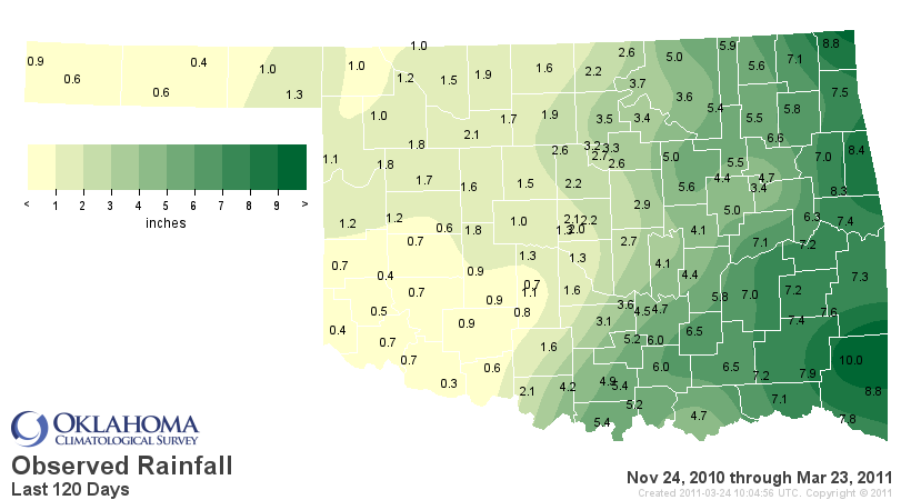
According to data from the Oklahoma Mesonet, the previous 120-day span (November
24, 2010-March 23, 2011) is the driest such period on record for central and
southwestern Oklahoma. The average rainfall recorded in central Oklahoma over
that period stands at 2.42 inches, 5.88 inches below normal. The southwest has
received a paltry 0.76 inches on average, a deficit of 5.09 inches. The dryness
extends over much of the western one-half of the state, including Oklahoma City,
which has had a total of 2.35 inches for a deficit of 4.94 inches.


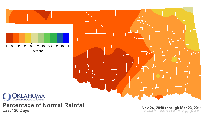
Precipitation totals are running less than 40 percent of normal for the western
one-half of the state, worsening to less than 20 percent of normal for
southwestern and parts of central Oklahoma. The statewide average of 3.45
inches for the last 120 days ranks as the third driest such period on record.
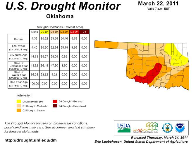
These statistics, along with growing reports of crop failures and dismal
pasture conditions, has prompted the U.S. Drought Monitor to expand the
"extreme drought" (D3) designation from southwestern Oklahoma up through
Oklahoma County.


Extreme drought is the second-worst designation possible on the Drought
Monitor's scale. Only "exceptional drought" (D4) is worse. According to
descriptions offered by the Drought Monitor, extreme drought is marked by
"major crop/pasture losses" or "widespread water shortages or restrictions."
Water restrictions are not occurring at this time, although reports of empty or
near-empty farm ponds are becoming widespread. Some reports from western
Oklahoma indicate the need for emergency assistance for livestock water will
soon occur if the dry conditions persist for much longer. Some reservoir levels
have dropped quite low. Lake Altus is now at 48 percent of capacity while the
lakes at Broken Bow and Eufaula are between 70-80 percent of capacity.

Soaring temperatures have exacerbated drought conditions over the last five
weeks. The statewide average temperature from February 15 to March 23 was 46.7
degrees, 9.7 degrees above normal. High temperatures reached 90 degrees 18
times during that period with the Mesonet sites at Altus and Hollis reporting
95 degrees on March 17. The unusual warmth increased evaporation and helped to
coax plants and trees out of dormancy early. Those factors can accelerate
drought?s progress by increasing the loss of available soil moisture. Those
moisture demands, as well as those from human consumption, will increase
further as the spring season continues.

Another impact of continued drought is the possibility of an extended spring
wildfire season. Normally, the green-up that occurs during spring tends to
suppress wildfire danger. Continued drought would result in more dormant and
dead vegetation, providing more fuel for wildfires.

Gary McManus
Associate State Climatologist
Oklahoma Climatological Survey
(405) 325-2253
gmcmanus@mesonet.org
March 24 in Mesonet History
| Record | Value | Station | Year |
|---|---|---|---|
| Maximum Temperature | 88°F | ALTU | 2003 |
| Minimum Temperature | 12°F | KENT | 2013 |
| Maximum Rainfall | 5.00″ | CLAY | 2023 |
Mesonet records begin in 1994.
Search by Date
If you're a bit off, don't worry, because just like horseshoes, “almost” counts on the Ticker website!