Ticker for September 8, 2010
MESONET TICKER ... MESONET TICKER ... MESONET TICKER ... MESONET TICKER ...
September 8, 2010  September 8, 2010  September 8, 2010  September 8, 2010


Who you gonna call? DROUGHTBUSTERS!

The rain can cause problems, but when you are in drought conditions going into
what looks like a strong La Nina winter, you take what you can get. Here are
the top rain totals from the Oklahoma Mesonet for tropical storm Hermine. Read
fast because these totals have already increased by the time you received this!

Durant	        3.58
Stigler	        3.38
Madill	        3.35
Cloudy	        3.32
Burneyville	3.31
Newport	        3.27
Ardmore	        3.12
Waurika	        2.77
Eufaula	        2.60
Medicine Park	2.33
Pauls Valley	2.27
Grandfield	2.27
Ringling	2.15
Walters	        2.08
Tishomingo	2.04

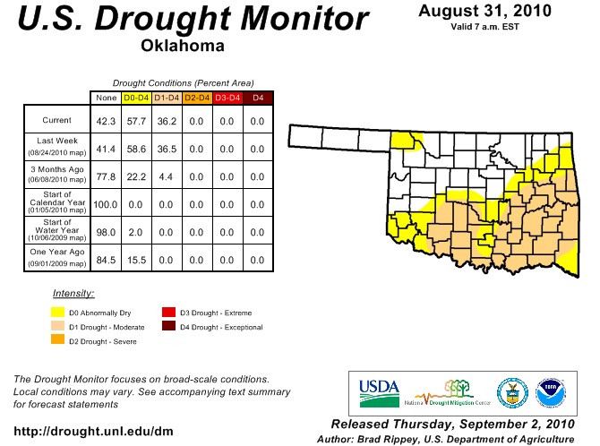
That should go a long way to getting rid of some of the colors on this map:


Gary McManus
Associate State Climatologist
Oklahoma Climatological Survey
(405) 325-2253
gmcmanus@mesonet.org
September 8 in Mesonet History
| Record | Value | Station | Year |
|---|---|---|---|
| Maximum Temperature | 111°F | GRA2 | 2023 |
| Minimum Temperature | 34°F | KENT | 2020 |
| Maximum Rainfall | 5.37 inches | WILB | 2001 |
Mesonet records begin in 1994.
Search by Date
If you're a bit off, don't worry, because just like horseshoes, “almost” counts on the Ticker website!