Ticker for August 26, 2010
MESONET TICKER ... MESONET TICKER ... MESONET TICKER ... MESONET TICKER ...
August 26, 2010    August 26, 2010    August 26, 2010    August 26, 2010


Drought Takes Hold in Oklahoma

The recent cool weather and smattering of rain enjoyed by Oklahoma came too late
to forestall the impacts from over a month of extreme temperatures and dryness.
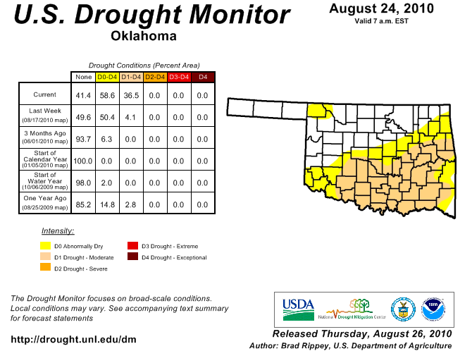
The latest depiction from the U.S. Drought Monitor indicates moderate drought has
now gained a foothold in the southeastern one-half of the state. While that is
the mildest intensity of drought the Drought Monitor reports, it is often the
precursor to more severe development. The Drought Monitor authors solicit advice
from local experts at the Oklahoma Climatological Survey and National Weather
Service to determine Oklahoma?s drought picture.


The short time it took for the current drought to develop is indicative of a
?flash drought? episode. A flash drought can occur when abnormally dry and hot
weather negatively affects vegetation and water supplies. Oklahoma was in
relatively decent shape going into the hottest and driest part of summer with
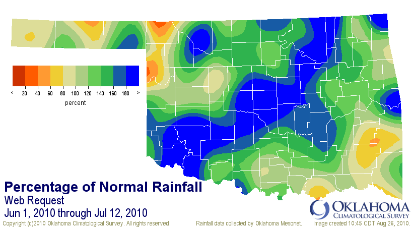
abundant moisture from June to mid-July. Statewide average rainfall statistics
from the Oklahoma Mesonet indicate the June 1-July 12 period was the 13th
wettest on record for Oklahoma with a surplus of 2.31 inches. Southwest
Oklahoma experienced its wettest such period on record with a surplus of over
4.30 inches. Mother Nature turned the spigots off shortly thereafter, however,
and the temperatures began to soar.


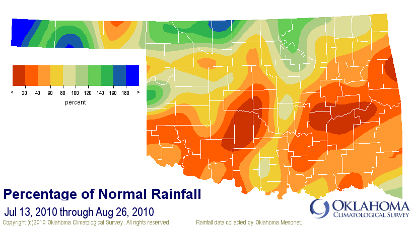
Much of the southern one-half of the state received 20-40 percent of normal
rainfall since July 12. More than 20 Oklahoma Mesonet stations in southwest,
central and east central Oklahoma have recorded less than an inch of rainfall
during that period. Oklahoma City has been particularly dry with a meager 0.09
inches of rainfall. Combine that dryness with 14 days of high temperatures at
or above 100 degrees and the prime ingredients for a flash drought are in place.


The cooler weather the state has seen over the last few days will help ease the
progression of the flash drought, but precipitation is now needed to ease the
dryness already in place. The state?s secondary rainy season of September and
early October is quickly approaching so perhaps some much-needed moisture
recharge is in store. Farther out, La Ni?a conditions currently developing in
the equatorial Pacific could mean a warmer, drier winter for the state so a
fall recharge could become even more important.

Gary McManus
Associate State Climatologist
Oklahoma Climatological Survey
(405) 325-2253
gmcmanus@mesonet.org
August 26 in Mesonet History
| Record | Value | Station | Year |
|---|---|---|---|
| Maximum Temperature | 110°F | WAUR | 2023 |
| Minimum Temperature | 46°F | SEIL | 2010 |
| Maximum Rainfall | 5.24 inches | BROK | 2020 |
Mesonet records begin in 1994.
Search by Date
If you're a bit off, don't worry, because just like horseshoes, “almost” counts on the Ticker website!