Ticker for August 4, 2010
MESONET TICKER ... MESONET TICKER ... MESONET TICKER ... MESONET TICKER ...
August 4, 2010     August 4, 2010     August 4, 2010     August 4, 2010


Not As Hot Front

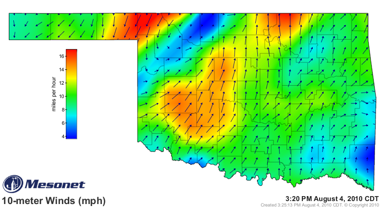
A "cool" front now stretches through northwestern Oklahoma, as indicated by the
Mesonet wind map where northerly winds meet southwesterly winds.


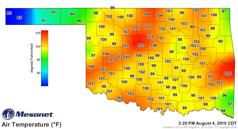
And that is also reflected in the air temperature map, with areas behind the
front a good 5-10 degrees cooler than ahead of the front.


Okay, with that bit of breathtaking scientific analysis out of the way (hey, it's
cooler behind the cool front!), there's something pretty interesting on that
map as well. Notice how the temperatures spike ahead of the front? I'm thinking
that might be due to compressional heating.

Taking a glance at that map once again, I hope at least ONE person out there took
my advice and visited Kenton ... 85 sounds pretty good right about now.

Talihina? Not so much.

Gary McManus
Associate State Climatologist
Oklahoma Climatological Survey
(405) 325-2253
gmcmanus@mesonet.org
August 4 in Mesonet History
| Record | Value | Station | Year |
|---|---|---|---|
| Maximum Temperature | 112°F | KIN2 | 2012 |
| Minimum Temperature | 54°F | NOWA | 2020 |
| Maximum Rainfall | 2.29 inches | JAYX | 1998 |
Mesonet records begin in 1994.
Search by Date
If you're a bit off, don't worry, because just like horseshoes, “almost” counts on the Ticker website!