Ticker for July 13, 2010
MESONET TICKER ... MESONET TICKER ... MESONET TICKER ... MESONET TICKER ...
July 13, 2010      July 13, 2010      July 13, 2010      July 13, 2010


Back to the frying pan

Our wet streak is apparently over, it would seem, and with a switch back to a
"normal" summer pattern, I'm afraid we're in for a miserable go of it for awhile.
Soil moisture is abnormally high for this time of year. Add that to July heat and
you have lots of potential water vapor. Now the actual air temperatures are not
too oppressive


which is one of the benefits of all that soil moisture. It does tend to keep the
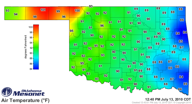
actual air temperatures down. Notice that Mesonet stations in the northwest have
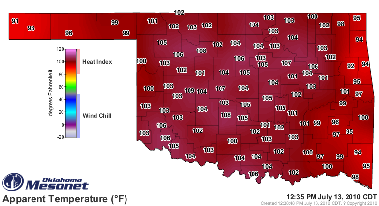
already reached 100 degrees out in the drier air. However, all that moisture
does little for the apparent air temperature or heat index, which is already at
full "YECH!" levels across the state (yes, "YECH" is an approved scientific
term in climatological circles):


You can watch how high the misery factor goes yourself using the heat index
map from the Oklahoma Mesonet:


The extreme heat has led to a heat advisory from the NWS office in Norman:

...HEAT ADVISORY IN EFFECT UNTIL 7 PM CDT THURSDAY...

THE NATIONAL WEATHER SERVICE IN NORMAN HAS ISSUED A HEAT
ADVISORY...WHICH IS IN EFFECT UNTIL 7 PM CDT THURSDAY.

* TEMPERATURE:HEAT INDICES OF 105 TO 110 ARE EXPECTED THROUGH
THURSDAY ACROSS OKLAHOMA AND WESTERN NORTH TEXAS. IN
ADDITION...OVERNIGHT LOWS IN THE MID TO UPPER 70S WILL MINIMIZE
THE RELIEF FROM THE HEAT.

* IMPACTS:INCREASED CONCERN FOR HEAT RELATED
ILLNESSES...ESPECIALLY IN URBANIZED AREAS.

PRECAUTIONARY/PREPAREDNESS ACTIONS...

A HEAT ADVISORY MEANS THAT A PERIOD OF HOT TEMPERATURES IS
EXPECTED. HOT TEMPERATURES AND HIGH HUMIDITY WILL COMBINE TO
CREATE A SITUATION IN WHICH HEAT ILLNESSES ARE POSSIBLE. DRINK
PLENTY OF FLUIDS...STAY IN AN AIR-CONDITIONED ROOM...STAY OUT OF
THE SUN...AND CHECK UP ON RELATIVES AND NEIGHBORS.


and an excessive heat warning issued by the NWS office in Tulsa:


THE NATIONAL WEATHER SERVICE IN TULSA HAS ISSUED AN EXCESSIVE HEAT
WARNING...WHICH IS IN EFFECT UNTIL 7 PM CDT THURSDAY...

HAZARDOUS WEATHER...
* HIGH PRESSURE WILL BUILD INTO THE REGION THIS WEEK ALLOWING
TEMPERATURES TO CLIMB TO NEAR OR ABOVE SEASONAL NORMALS. WITH
SATURATED SOILS FROM RECENT RAINFALL AND A PREVAILING SOUTHERLY
FLOW... VERY HUMID CONDITIONS WILL REMAIN ENTRENCHED ACROSS THE
REGION. THIS WILL TRANSLATE TO HIGH HEAT INDEX VALUES... WITH
MANY AREAS REACHING 105 AND ABOVE.

IMPACTS...
* THE COMBINATION OF HOT TEMPERATURES AND HIGH HUMIDITY WILL
COMBINE TO CREATE A DANGEROUS SITUATION IN WHICH HEAT ILLNESSES
ARE POSSIBLE.


Sorry, no relief in sight. But no worries, in Oklahoma, this is what we call
"summer".

Gary McManus
Associate State Climatologist
Oklahoma Climatological Survey
(405) 325-2253
gmcmanus@mesonet.org
July 13 in Mesonet History
| Record | Value | Station | Year |
|---|---|---|---|
| Maximum Temperature | 109°F | LAHO | 2003 |
| Minimum Temperature | 52°F | BOIS | 2008 |
| Maximum Rainfall | 4.29 inches | CLAY | 2025 |
Mesonet records begin in 1994.
Search by Date
If you're a bit off, don't worry, because just like horseshoes, “almost” counts on the Ticker website!