Ticker for May 12, 2010
MESONET TICKER ... MESONET TICKER ... MESONET TICKER ... MESONET TICKER ...
May 12, 2010 May 12, 2010 May 12, 2010 May 12, 2010
Tornadoes Aplenty
Sometimes we'd rather be wrong than right, but as feared, we no longer get to
ponder our slow start to the tornado season. Many tornadoes dropped from the sky
a couple of days ago (including one that formed a stones throw from my house!),
increasing the total for the year from three to much-more-than-three. I hesitate
to give out a definite number since the NWS is still surveying the damaged
areas.
I'm sure you've heard figures ranging from as low as 10 to as many as 30+...and
reality obviously lies somewhere in the middle. The problem is that sometimes a
single tornado path can be seen, at least preliminarily, as several, and the
same problem exists in the reverse ... several paths can end up being a single
tornado. And the existence of damage doesn't always mean tornado. Straight-line
winds and the associated damage from supercell thunderstorms can often resemble
a tornado strike. So the NWS takes great care in going out and surveying those
sites to give us a fairly exact number.
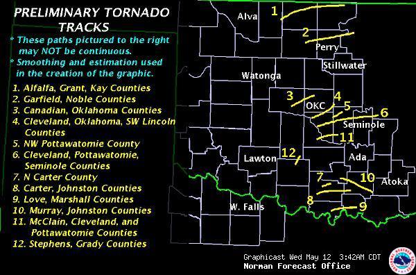
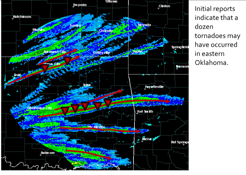
Here are the graphical takes from our NWS offices in Norman and Tulsa:
Watch for updates from both offices as they pinpoint the exact number of
tornadoes. Unfortunately, the worst toll came in the form of lives, as three
fatalities have been confirmed at this time. Let's hope that count stands pat.
May 10 is a day we should think about eradicating from the calendar.
The preliminary count of two deaths yesterday are joined by other bad tornado
days in the state, including the Picher EF4 tornado of May 10, 2008, which
killed six in Oklahoma. Yesterday was also the 105th anniversary of the
Snyder tornado that killed 97.
Burbank Mesonet Site Measures Tornadic Circulation
Kudos to Tulsa NWS chief Steve Piltz and his gang for spotting a lovely time had
by the Burbank Mesonet site as a tornado passed either close by or over the
site. Here is the Burbank meteogram from that time period:
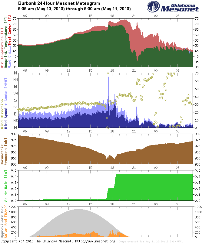
Shortly after 5 p.m. (17 on the time scale), you can see a sudden spike in wind
speed with gusts up to 65 mph. The wind direction switches from SE to E to NE
to N, then back to SE, all in the matter of a half an hour. You can also see
the pressure drop associated with the tornadic circulation, then the dryline
passage shortly after 9 p.m.
The 5-minute data during the mesocyclone passage over the site is depicted
below:
D
M E S
Y O D H T W O
E N A O M E WIND L
A T T U I M P ------------- A
R H E R N PRES P T RH DIR SPD MAX RAIN R
-------------------------------------------------------------------------
BURB 2010 05 10 17 05 28.40 67 63 88 138 19 31 0.07 12
BURB 2010 05 10 17 10 28.34 67 64 89 120 21 30 0.07 10
BURB 2010 05 10 17 15 28.33 67 64 89 64 20 33 0.08 6
BURB 2010 05 10 17 20 28.37 66 64 92 2 21 37 0.16 3
BURB 2010 05 10 17 25 28.33 68 66 94 357 40 65 0.23 103
BURB 2010 05 10 17 30 28.38 71 69 92 0 31 64 0.24 43
BURB 2010 05 10 17 35 28.42 73 69 88 174 16 27 0.24 42
BURB 2010 05 10 17 40 28.41 72 68 88 178 22 31 0.24 213
Here is some preliminary survey results by the Tulsa NWS describing that
tornado:
A SURVEY TEAM FROM THE NATIONAL WEATHER SERVICE IN TULSA CONFIRMED
THAT A TORNADO OCCURRED IN WESTERN OSAGE COUNTY ON THE EVENING OF
10 MAY 2010.
THE TORNADO LIKELY ENTERED OSAGE COUNTY FROM NOBLE COUNTY. THIS
WILL BE CONFIRMED THROUGH COORDINATION BETWEEN THE NORMAN AND
TULSA NATIONAL WEATHER SERVICE OFFICES.
TORNADO DAMAGE BEGAN IN OSAGE COUNTY AT APPROXIMATELY 514 PM CDT
12.3 MILES SOUTHWEST OF BURBANK. THE TORNADO TRAVELED TO THE
NORTHEAST AT NEAR 60 MPH AND WAS ON THE GROUND FOR 11 MILES...
LIFTING 3.1 MILES SOUTH OF BURBANK.
THE TORNADO WAS 1.4 MILES WIDE AND WAS PART OF A 2.6 MILE WIDE
DAMAGE SWATH. THE LARGER DAMAGE SWATH IS A COMBINATION OF
TORNADO DAMAGE AND STRONG REAR FLANK DOWNDRAFT WINDS THE REACHED
NEAR 85 MPH IN A FEW LOCATIONS. THE TORNADO WAS GIVEN A PRELIMINARY
RATING OF EF-1 ON THE ENHANCED FUJITA SCALE. THE PEAK WINDS OF THE
TORNADO WERE ESTIMATED NEAR 110 MPH.
Keep an eye out for the NWS summaries to become more finalized over the next
few days:
Tulsa: http://www.srh.noaa.gov/tsa/
Norman: http://www.srh.noaa.gov/oun/
Gary McManus
Associate State Climatologist
Oklahoma Climatological Survey
(405) 325-2253
gmcmanus@mesonet.org
May 12 in Mesonet History
| Record | Value | Station | Year |
|---|---|---|---|
| Maximum Temperature | 99°F | HOOK | 2022 |
| Minimum Temperature | 36°F | ANTL | 2008 |
| Maximum Rainfall | 5.55 inches | COOK | 2016 |
Mesonet records begin in 1994.
Search by Date
If you're a bit off, don't worry, because just like horseshoes, “almost” counts on the Ticker website!