Ticker for May 5, 2010
MESONET TICKER ... MESONET TICKER ... MESONET TICKER ... MESONET TICKER ...
May 5, 2010        May 5, 2010        May 5, 2010        May 5, 2010


April's in the books

Happy Cinco de Mayo, or as we used to call it in Buffalo, the fifth of May.
We're so far out in the sticks we didn't celebrate it until the sixth. I
have the summarized Oklahoma Mesonet data for April 2010, cold off the presses.

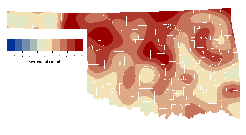
April was the 29th warmest on record (dating back to 1895) with a statewide
average temperature of 61.0 degrees, 1.9 degrees above normal. As you can see
in the graphics below, southern Oklahoma was warmer (as is what normally occurs
during April), but the north was more above normal. There were a few spots that
ended cooler than normal, but not many. If you break that down into highs and
lows, the high temperatures came in close to normal at 72.1 degrees but the lows
were 3.1 degrees above normal at 49.3 degrees. The highest temperature for the
month was 94 degrees, recorded at Buffalo on the fifth. The lowest temperature
was 21 degrees from Boise City on the 8th. Of the 120 Mesonet stations, 77 did
not record a temperature below freezing during April.


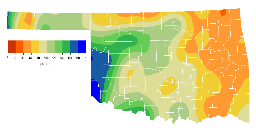
The statewide average precipitation total was 0.56 inches below normal at 2.80
inches, the 48th-driest April since 1895. As seen in the Mesonet precipitation
maps below, it was fairly wet in the far west and fairly dry in the east and
along the northern border. Those areas will bear watching for developing
drought, especially up in Woods and Alfalfa counties. The highest precipitation
total was 5.86 inches recorded at Burbank. The low total comes in from Boise
City with 0.89 inches.


Not much severe weather to speak of with just a few bouts of storms during the
month. One small tornado dropped in Beaver County on the 22nd ... only the
third tornado for Oklahoma in 2010 thus far and one of the slowest starts to the
tornado season (DUCK SEASON! RABBIT SEASON!!! sorry, Looney Tunes flashback
there) in recent memory. The strongest wind gust measured by the Mesonet was
74 mph at Medford on the fifth. There was an 81-mph measurement reported by the
Vance Air Force Base ASOS on the 23rd in Enid and an unofficial report of an
88-mph gust recorded by equipment on a building in Enid shortly thereafter.

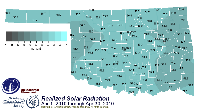
And finally, most of the state saw between 55-60 percent of possible sunshine
during the month:


Watch for our official monthly summary that contains even more information to
come out in the next couple of days. You can find it (and past summaries) here:

http://climate.mesonet.org/monthly_summary.html

Sayonara!

Gary McManus
Associate State Climatologist
Oklahoma Climatological Survey
(405) 325-2253
gmcmanus@mesonet.org
May 5 in Mesonet History
| Record | Value | Station | Year |
|---|---|---|---|
| Maximum Temperature | 106°F | ALTU | 2012 |
| Minimum Temperature | 29°F | KENT | 2013 |
| Maximum Rainfall | 4.13″ | WEB3 | 2022 |
Mesonet records begin in 1994.
Search by Date
If you're a bit off, don't worry, because just like horseshoes, “almost” counts on the Ticker website!