Ticker for March 23, 2010
MESONET TICKER ... MESONET TICKER ... MESONET TICKER ... MESONET TICKER ...
March 23, 2010     March 23, 2010     March 23, 2010     March 23, 2010


A Little March/Spring Break Snow Perspective

Now that the hysteria of this wacky/crazy/unheard-of March snowstorm has died
down, how about a look back at some other March/Spring Break Oklahoma
snowstorms? So let's travel back back back back (GONE! HOME RUN!! Sorry,
baseball season is upon us), all the way back to, uhhhhh, last year? Yes,
gentle reader, it was just a year ago (a year ago NEXT week, to be exact) that
much of northwestern Oklahoma saw snow measured in FEET (or with feet, for
those of us that need their toes for the new math).

From a previous Ticker:

**********

"The State Climate Extremes Committee declared the 26.0 inches of snow recorded
by the Woodward and Freedom National Weather Service (NWS) cooperative
observing sites during the March 27-28 blizzard in northwestern Oklahoma a new
all-time 24-hr state snow fall record.

Arguably the greatest Oklahoma springtime blizzard in living memory occurred on
the 27th of March, 2009, carrying into the morning hours of the 28th. The storm
system contained heavy snow bands and significant convective activity that
included hail and thunder snow in places.

Reports of over 20 inches of snow fall were received from numerous locations
throughout the area, and several reported over 24 inches (the existing state
record 24‐hr snow fall for Oklahoma is 23.0 inches, set at Buffalo on 21
February 1971). An unofficial report of 27.0 inches was also received from a
private citizen in Slapout."

**********

So the blizzard that struck some 360 days ago was a whopper, dwarfing even the
latest pretender to the crown, the Christmas Eve blizzard of 2009. However,
the Christmas Eve blizzard certainly affected more of the state's population.
It's hard to ignore the significance of 26 inches of snow and 10-foot drifts,
however.

Truth be told, the snow of last week even pales in comparison to another
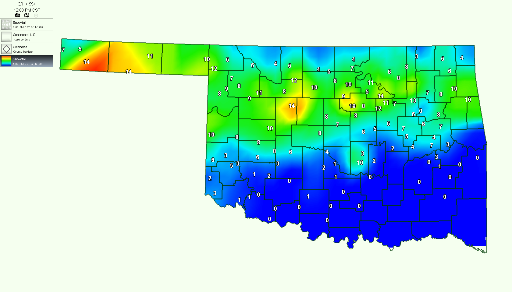
recent spring break snowstorm. That prize goes to the March 8-10, 1994,
event ... or what I like to call "THE CRAPPIEST SPRING BREAK EVER!" And please
keep in mind that spring breaks were not so consolidated back then but I was
on spring break so that's all that matters.

Severe thunderstorms on the seventh brought large hail, damaging winds and
reports of funnel clouds along a cold front that was barreling through the
state. The thunder didn't exactly stop on the eighth, it simply became thunder
snow. The next couple of days saw heavy snow fall across the northern half of
the state with as much as 19 inches being reported from Stillwater.


Now THAT was a spring break to remember. I, on the other hand, would rather
try and forget!

Gary McManus
Associate State Climatologist
Oklahoma Climatological Survey
(405) 325-2253
March 23 in Mesonet History
| Record | Value | Station | Year |
|---|---|---|---|
| Maximum Temperature | 95°F | BEAV | 2018 |
| Minimum Temperature | 17°F | BOIS | 2013 |
| Maximum Rainfall | 3.91 inches | INOL | 2023 |
Mesonet records begin in 1994.
Search by Date
If you're a bit off, don't worry, because just like horseshoes, “almost” counts on the Ticker website!