Ticker for February 17, 2010
MESONET TICKER ... MESONET TICKER ... MESONET TICKER ... MESONET TICKER ...
February 17, 2010 February 17, 2010 February 17, 2010 February 17, 2010
El Nino 2009-10: Boon and Curse
The folks at the Climate Prediction Center (CPC) have now categorized the El Nino
of 2009-10 as "strong and mature" (think "the opposite of the current Associate
State Climatologist). In fact, with an Oceanic Nino Index (ONI) of 1.8, the
current episode is the strongest since the 1997-98 super El Nino, which had a
peak ONI of 2.5.
What has that meant for Oklahoma? Well, it's now fairly obvious the current El
Nino has had an influence on our weather, and has been both boon and curse for
the state. Several very powerful storm systems have crossed paths with Oklahoma
this winter, and each of those storms has had plenty moisture to work with. We
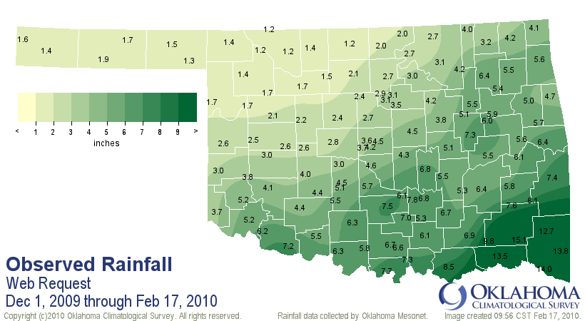
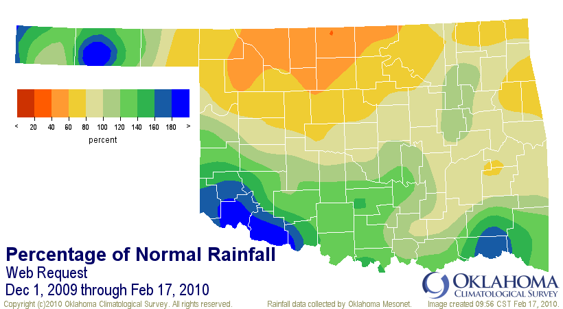
can see El Nino's influence in our precipitation maps since climatological
winter began on December 1 with above average rainfall in the southern sections
of the state, exactly where you would expect it to be (the farther south you
go in the Southern Plains, the impacts of El Nino become more important):
Combine those storms with the shenanigans of the Arctic Oscillation this winter
(more on that tomorrow, hopefully) and you have the perfect combination of
ingredients to recharge Oklahoma's soil moisture (i.e., plenty of frozen
precipitation). Frozen precipitation is great at replenishing moisture in the
soil since it results in reduced runoff. Like a soaker hose, as the snow or
ice melts it percolates into the soil. With greatly diminished
evapotranspiration demands and less consumption by humans, that moisture can
therefore replenish the water supply before demands ramp up again in spring.
Check out the Fractional Water Index (FWI) from today:
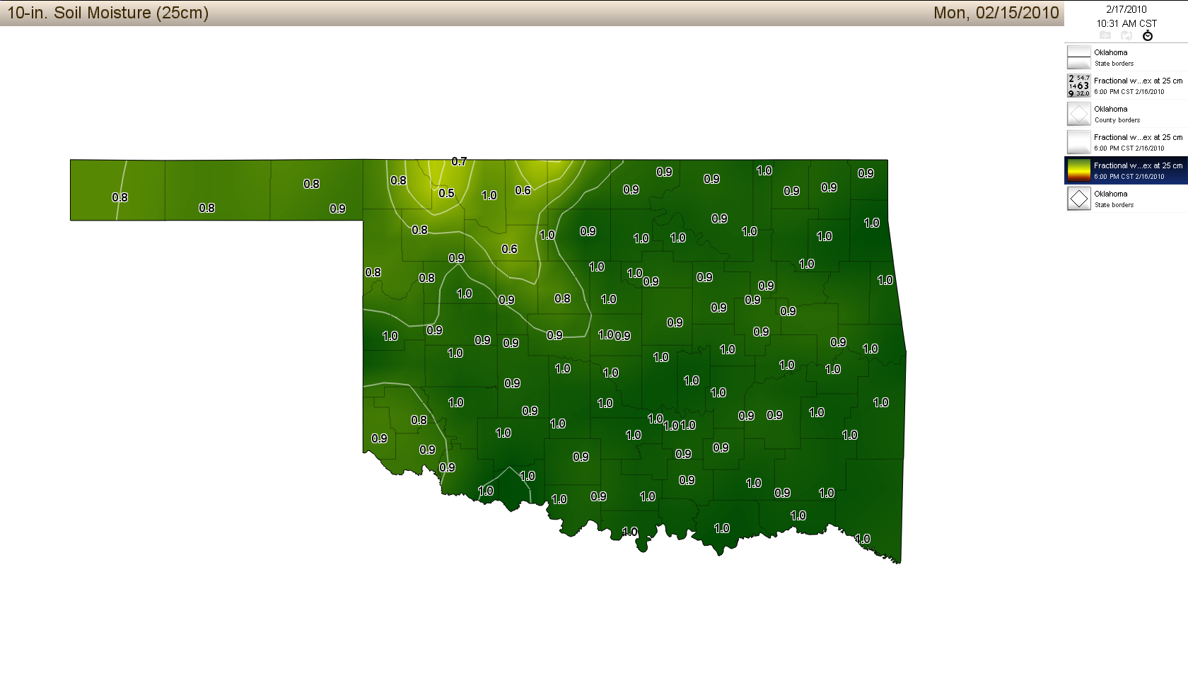
It's not often that you see the soil so saturated at 10 inches across the entire
state like that. In fact, it's somewhat of an abomination to this Panhandle
native ... if you walk outside and your soil makes a squishing sound, something
ain't right!
Okay, that's the boon (and being from the boondocks, I know boon!). The curse
is rather obvious, with the Christmas Eve blizzard and 200,000 electric
utility customers left without power from our latest significant ice storm.
Those two winter storms alone will end up costing our state hundreds of
millions of dollars in damage and clean-up costs and the inclement weather has
been blamed for more than a dozen deaths.
Now climate types try not to blame any single event (or two) on an interannual
influence like El Nino, but the southerly storm track has been quite evident
this winter so we're going anecdotal:
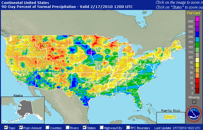
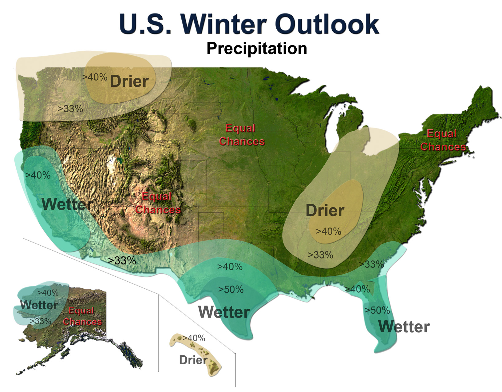
Those increased precipitation areas match up reasonably well to the winter
outlooks issued previously:
The CPC expects El Nino conditions to continue into this spring before tapering
off over summer, so we could continue to see that southerly storm track being
very active. Whether that's a boon or curse remains to be seen.
Gary McManus
Associate State Climatologist
Oklahoma Climatological Survey
(405) 325-2253
February 17 in Mesonet History
| Record | Value | Station | Year |
|---|---|---|---|
| Maximum Temperature | 85°F | ALTU | 2011 |
| Minimum Temperature | -2°F | HOLL | 2021 |
| Maximum Rainfall | 1.56″ | TULN | 2022 |
Mesonet records begin in 1994.
Search by Date
If you're a bit off, don't worry, because just like horseshoes, “almost” counts on the Ticker website!