Ticker for January 5, 2010
MESONET TICKER ... MESONET TICKER ... MESONET TICKER ... MESONET TICKER ...
January 5, 2010    January 5, 2010    January 5, 2010    January 5, 2010


BRRRRRRRRRR!!!

Mother Nature is definitely getting her revenge for that pleasant November we
experienced. The cold weather of the 10th-coolest December has continued
into January, and our coldest weather of the season is nearly upon us. Want
to feel better about the single-digit lows and the below-zero wind chills
coming up? Read this - brazenly ripped off from a piece by a brilliant yet
overly-modest Associate State Climatologist in our 2008-09 Winter Seasonal
Climate magazine. Also note that two historical blizzards have struck the state
since this article was published.

http://climate.mesonet.org/seasonal_summary/Oklahoma_Climate_Winter_2008-09.pdf

THE OKLAHOMA DEEP FREEZE OF DECEMBER 1983

Think back, dear reader, to times of yore, when telephones had cords and video
games consisted of two vertical lines and a dot. It was during these ancient
times, the 1970s and 1980s, in which Oklahomans were able to experience actual
winters, complete with snow and lengthy cold spells. It can certainly get cold
from time-to-time during our current winters, of course. The warming that has
taken place over the last 20-30 years, however, has left a generation of young
Oklahomans with no inkling of what a truly cold winter can be like. There was a
time when snow fell instead of freezing rain, and farmers spent their mornings
busting ice from stock tanks before their first cup of hot java at the local
cafe. So I ask you again, dear reader, to travel 25 years into Oklahoma?s past,
and relive the Oklahoma Deep Freeze of December 1983.

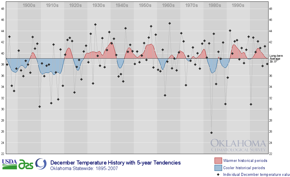
Figure 1:  Statewide average December temperatures since 1895 for Oklahoma:


The first three weeks of December 1983 were actually quite pleasant as far as
Decembers in Oklahoma go. High temperatures were near of above normal for most
of that time with just a few intrusions of cold air to speak of. The state?s
first snowfall of any significance fell on the 13th but temperatures were too
warm for the snow to last. Temperatures the next day rose into the 40s,
obliterating the last traces of the frozen precipitation. A cold front late on
the 15th combined with an upper-level low traveling from the west across
Oklahoma to produce snowfall amounts of up to 8 inches along the Red River.
Little did Oklahomans know that the cold front and snow were just the beginning
of their wintry trouble.

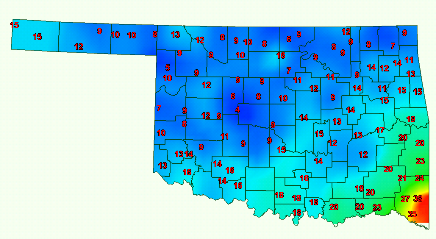
Figure 2: High temperatures on December 19, 1983:


Yet another cold front on the 17th brought a reinforcing blast of cold air to
Oklahoma with more snow. The temperature at Guymon had dropped to 7 degrees by
5 p.m. and winds of up to 40 mph produced wind chills down to 20 degrees below
zero. The 18th saw the cold air spread statewide with high temperatures
struggling into double digits across most of the state. Strong winds dropped
the wind chills down to 35 degrees below zero in some areas. As if the cold was
not enough of a hardship for Oklahomans, Mother Nature gave them a good dose of
freezing rain on the 20th as an exclamation point. The southern half of the
state became a skating rink and travel was treacherous, resulting in many
accidents.

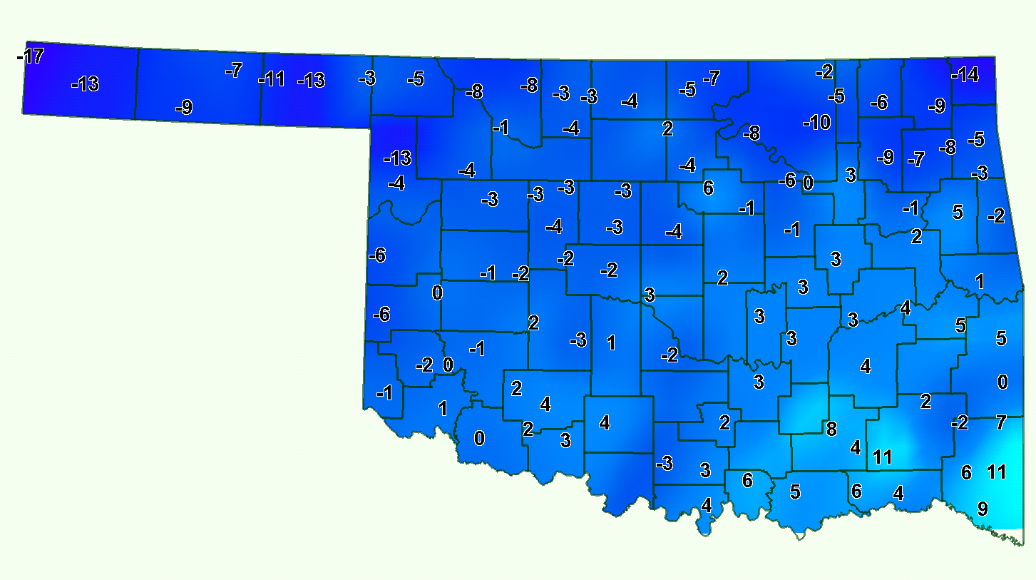
Figure 3: Low temperatures on December 29, 1983:


Yet another surge of arctic air arrived on the 21st that sent temperatures
plunging once again. Oklahoma City broke its record low temperature with a
mark of 2 degrees below zero, and wind chills in some parts of the state were
as low as 40 degrees below zero. The high temperature at the Great Salt Plains
reservoir on the 22nd was 4 degrees below zero after a low temperature of 5
degrees below zero. Christmas Eve and Christmas Day saw Santa bring Oklahoma
another blast of cold air and wind chills of 50 degrees below zero. Low
temperatures across most of northern Oklahoma were below zero and high
temperatures were in the low single digits. A warm up into the balmy 20s
occurred for several days before a final-yet-brutal blast of cold air late on
the 27th provided the state with its coldest temperature of the event; 17
degrees below zero was reported from the far western Panhandle town of Kenton
on the 29th. A reading of 16 degrees below zero was recorded at Hulah Dam in
Osage County the following day. Travel was discouraged on the 27th and 28th
after nearly every road in the state was left covered with snow and ice.

New Year?s Eve marked the end of the arctic transformation with temperatures
rising above freezing for the first time since the first frigid blast on the
17th. Within days, temperatures were in the 60s across much of the state,
putting the final nail in the coffin of the event. The month ended as the
coldest December on record statewide with an average temperature of 25.8
degrees, 13.2 degrees below normal. Only four months have been colder in
Oklahoma than December 1983, and all occurred in January:  1918, 1930, 1940,
and 1979. The temperature in Oklahoma City was below freezing from 3 p.m. on
the 18th to 10:45 a.m. on the 31st, the longest such stretch ever recorded.
Nine daily records were also set in Oklahoma City ? five for coldest high
temperature and four for coldest low temperature.

The event left more than just a populace chilled to its bones, however. More
than 20 deaths were blamed directly on the cold weather, mostly from traffic
accidents, carbon monoxide poisoning, and exposure. Infrastructure also took
a hit due to the arctic chill. Frozen water pipes left thousands without water
for days, and when those pipes did thaw, hefty plumber bills ensued. Fire
departments in Oklahoma City became emergency water distribution points for
those with frozen pipes. And the misery was not confined to Oklahoma, of
course. Most of the eastern half of the nation was gripped in the wintry
weather?s hold for a similar duration. Nationally, more than 500 deaths were
attributed to the cold weather, as well as the destruction of infrastructure
and crops. The Red River in Shreveport was reportedly clogged with the most
ice since 1895, and damages in Texas alone were estimated at over $100 million.

Gary McManus
Associate State Climatologist
Oklahoma Climatological Survey
(405) 325-2253
January 5 in Mesonet History
| Record | Value | Station | Year |
|---|---|---|---|
| Maximum Temperature | 79°F | WAUR | 2008 |
| Minimum Temperature | -3°F | KENT | 2014 |
| Maximum Rainfall | 2.19″ | JAYX | 2005 |
Mesonet records begin in 1994.
Search by Date
If you're a bit off, don't worry, because just like horseshoes, “almost” counts on the Ticker website!