Ticker for November 11, 2009
MESONET TICKER ... MESONET TICKER ... MESONET TICKER ... MESONET TICKER ...
November 11, 2009  November 11, 2009  November 11, 2009  November 11, 2009


A Palindrome to Remember, and October Still Providing Scares

Okay, this is probably a day late (and I'm always a dollar short), so I hope you
can all still rush to the party store after work for your "11/11/11" celebration
supplies ... 23 SKIDOO! Of course it's not 11/11/2011 that we're worried about.
By then we'll all probably be preparing for the end of the world in 2012. No,
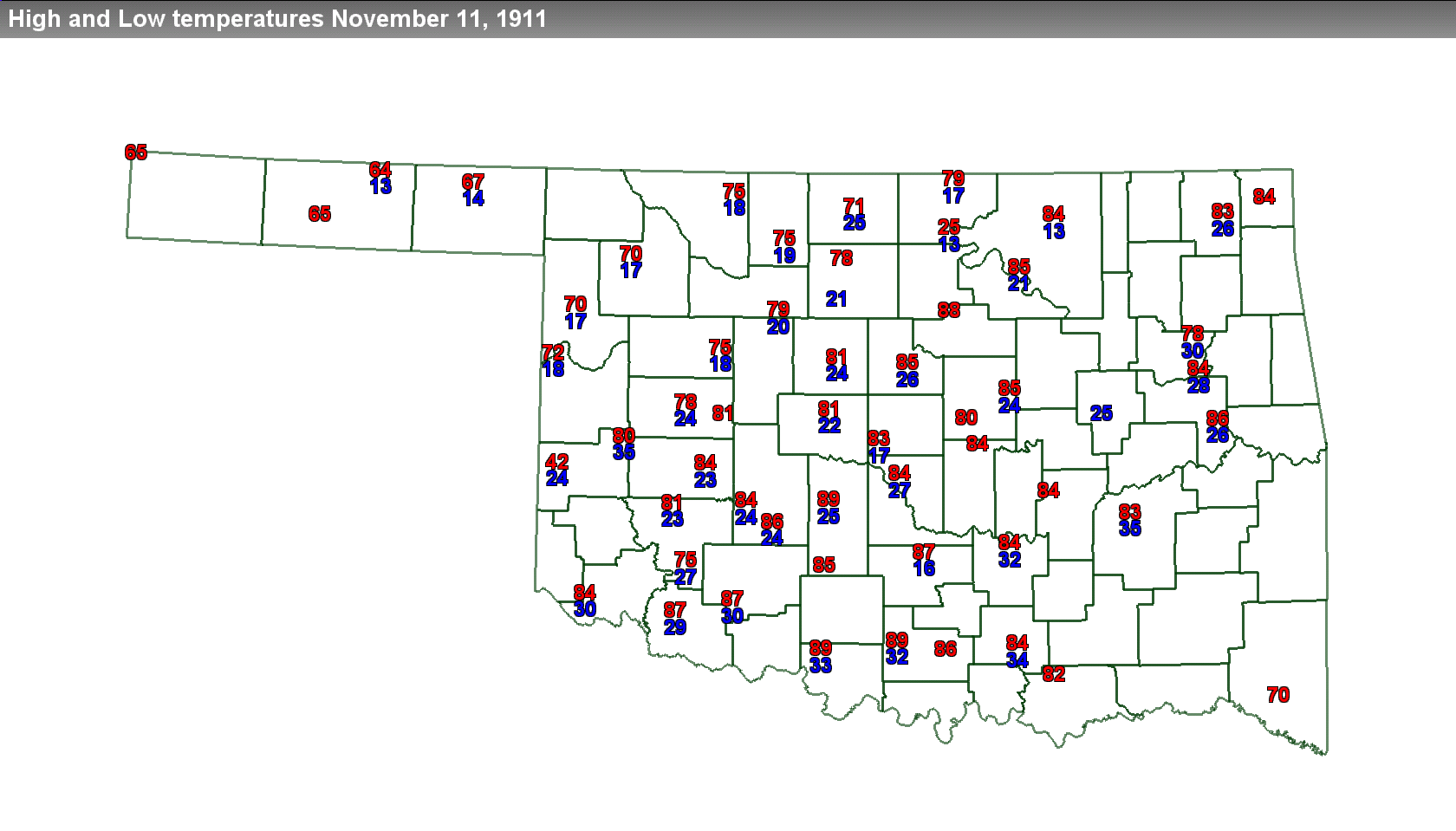
this celebration is for what occurred nearly a century ago on November 11, 1911.

On that afternoon, Oklahoma City reached a record high temperature of 83 degrees.
Soon thereafter, a ?norther? barreled through the state, dropping temperatures
50-65 degrees in the span of a few hours. By midnight, the temperature at
Oklahoma City had plunged to a frigid 17 degrees, the record low for that same
date.


Both records still stand, marking November 11th, 1911, as the only date in
state history in which the record high and low temperatures were broken on the
same day for a single location. National Weather Service forecasts indicate the
milestones will be safe for yet another year. NWS forecasts are calling for
high temperatures in the 60s and lows in the 50s.


October Just Got A Bit Cooler

As you may recall, our monthly climate summary indicated that October finished
as the second coldest on record according to data from the Oklahoma Mesonet.
The statewide average temperature according to the Mesonet was 54.5 degrees, a
tenth of a degree off the old record of 54.4 degrees set in 1925. The
statewide average temperature just released by the National Climatic Data
Center (NCDC), however, was 54.3 degrees, marking October 2009 as the coldest
on record (1895-2009). In addition, the August-October statewide average
temperature was also the coldest on record for Oklahoma, Kansas and Nebraska.

NCDC uses NWS cooperative data, which is still the official data set of record
in the U.S. Just a couple of caveats remain, however. The coop data used by
NCDC to determine that record last month are still considered preliminary. The
"official" data won't come out for about 6 months. And to complicate matters
further, many Oklahoma Mesonet stations are also coop stations.

Confused? Good. By the time you figure it out, it will be too late!

(insert evil scientist laugh here)

Gary McManus
Associate State Climatologist
Oklahoma Climatological Survey
(405) 325-2253
November 11 in Mesonet History
| Record | Value | Station | Year |
|---|---|---|---|
| Maximum Temperature | 86°F | SLAP | 2005 |
| Minimum Temperature | 1°F | EVAX | 2019 |
| Maximum Rainfall | 1.24″ | COPA | 2012 |
Mesonet records begin in 1994.
Search by Date
If you're a bit off, don't worry, because just like horseshoes, “almost” counts on the Ticker website!