Ticker for August 19, 2009
MESONET TICKER ... MESONET TICKER ... MESONET TICKER ... MESONET TICKER ...
August 19, 2009    August 19, 2009    August 19, 2009    August 19, 2009


Let me tell you why, despite two meteorology degrees from the University of
Oklahoma, I decided to become a climatologist:

1. The money (Yes, that's a joke. I would laugh but I'm crying...meteorologists,
join in).
2. Typical meteorologist - Dusty from "Twister"

3. Typical climatologist - Jack from "The Day After Tomorrow"


And finally, the biggest reason:

3. My wife last night: "Is it supposed to rain tonight?"
Me: "No."

Silly me. My forecasting skills aside, I could have at least looked at a
forecast I guess, but I was all caught up in a 0.03-inch discrepancy we found
in an October 1963 rainfall total from Regnier. It's 24/7 excitement here at
the Climate Survey!

So, yet another night awakened by thunderstorms screaming across the state.
It does tend to get a bit difficult to sleep when electrified fingers of death
are raining down upon the Earth. However, if you're going to get rains in the
warm season, they will generally be accompanied by lovely side effects such
as lightning, high winds and hail. We Okies understand that, of course, and put
up with a lot just for the joy of that rainfall. It's August after all, which is
normally our 2nd hottest and 5th driest month (2nd driest warm season month).
In other words, WE'LL TAKE IT!

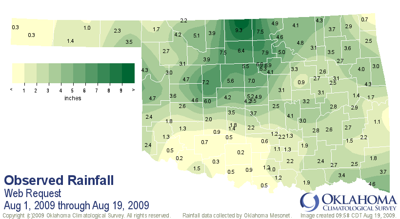
So far this August has been well above normal over most of the state. The
statewide average total for August thus far is 2.99 inches, 1.30 inches above
normal and ranked as the 11th wettest such period on record. And rain is falling
as I type this.


That monthly total is buoyed by some extreme amounts in north central Oklahoma.
The Oklahoma Mesonet station at Medford has received 9.3 inches of rain so far
in August which is more than 6 inches greater than what that area averages for
the entire month. The all-time record for August at the nearest long-term COOP
station, Jefferson, is 10.19 inches, so one more good rain could punch it past
that mark.

As we can see, though, some parts of the state haven't been so fortunate. The
Mesonet sites at Ketchum Ranch and Tipton have only received 0.2 inches for
the month:


And 20% of normal precipitation is not fun during August:


Combine that with June and July totals and you have a decently wet summer thus
far for much of the state:


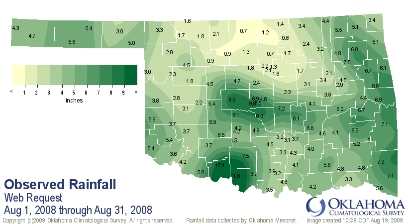
And if you are thinking "Wow, this is one of the wettest Augusts I can
remember," well, your memory might be fading. Harken back to 2008 when the
state experienced its 13th wettest August with a statewide average of 4.38
inches, 1.62 inches above normal. Norman itself had a total of 10.3 inches,
about 8 inches above normal and its wettest August on record.


By the way, the "Twister" and "The Day After Tomorrow" comparison isn't really
representative. Phillip Seymour Hoffman is somewhere right now snickering at
my picture.

Gary McManus
Associate State Climatologist
Oklahoma Climatological Survey
(405) 325-2253
gmcmanus@mesonet.org
August 19 in Mesonet History
| Record | Value | Station | Year |
|---|---|---|---|
| Maximum Temperature | 111°F | GRA2 | 2024 |
| Minimum Temperature | 51°F | ELRE | 2015 |
| Maximum Rainfall | 8.55 inches | OKMU | 2007 |
Mesonet records begin in 1994.
Search by Date
If you're a bit off, don't worry, because just like horseshoes, “almost” counts on the Ticker website!