Ticker for July 9, 2009
MESONET TICKER ... MESONET TICKER ... MESONET TICKER ... MESONET TICKER ...
July 9, 2009       July 9, 2009       July 9, 2009       July 9, 2009


El Ni?o is here!

No, I'm not a father once again, nor is this a significant Biblical event. We're
talking the climate phenomenon where the equatorial pacific waters warm a bit and
affect weather around the globe.

Quoting the NOAA press release on the subject:

NOAA scientists today announced the arrival of El Ni?o, a climate phenomenon
with a significant influence on global weather, ocean conditions and marine
fisheries. El Ni?o, the periodic warming of central and eastern tropical
Pacific waters, occurs on average every two to five years and typically lasts
about 12 months.

Sea surface temperatures along the equatorial Eastern Pacific, as of July 1,
are at least one degree above average ? a sign of El Ni?o. NOAA expects this
El Ni?o to continue developing during the next several months, with further
strengthening possible. The event is expected to last through winter 2009-10.

Read the entire press release here:

http://www.noaanews.noaa.gov/stories2009/20090709_elnino.html

Or for a more detailed (i.e. harder to understand) version, check out the
CPC/NCEP diagnostic discussion:

http://www.cpc.ncep.noaa.gov/products/analysis_monitoring/enso_advisory/ensodisc.html

Keep in mind that CPC considers El Ni?o or La Ni?a *CONDITIONS* to occur when
certain oceanic anomalies are present along with consistent atmospheric
features.  These anomalies must also be forecasted to persist for 3 consecutive
months. By historical standards, to be classified as a full-fledged El Ni?o
episode, these thresholds must be exceeded for a period of at least 5
consecutive overlapping 3-month seasons.

Now, what's it mean for Oklahoma? Well, it depends on the El Ni?o, and not all
are alike. It can mean a cooler and wetter signal during the cool months, but
that signal is much stronger for points south of here. However, during strong
El Ni?o events, we have seen those impacts in Oklahoma.

The Oklahoma Climatological Survey studied 20 previous El Ni?o episodes from
1950-2005 and tracked the corresponding October-March precipitation totals in
an effort to detail the warm pacific water's effects on Oklahoma's climate. Of
the 20 El Ni?o episodes, four were considered "strong", while the remaining 16
events were broken down into eight of both "moderate" and "weak"
classifications.

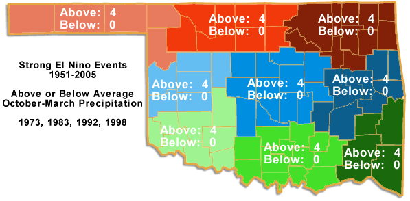
The influence of the four strong events was easily seen, with above average
rainfall in all areas of the state. In fact, the wettest October-March since
1951 occurred in east central Oklahoma with the strong El Ni?o of 1998, along
with the 2nd wettest such period in the southeast. This follows typical El Ni?o
influences in which the southeastern United States receives above average
moisture. The effect extends westward into southeastern Oklahoma during a
strong event, and can actually extend farther west to benefit the entire state.

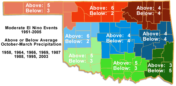
Moderate El Ni?o events appear to influence the weather differently across the
state. Western Oklahoma has in increased chance of above average rainfall in
the case of a moderate event, while the results for eastern and central
Oklahoma are nondescript. Of the eight moderate events tracked, north central
and west central Oklahoma had above average rainfall in six of those instances,
while the Panhandle, southwest, and south central areas observed above average
precipitation five times.

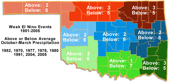
The prospects for drought relief become bleak during weak events. All areas of
the state experienced below average precipitation during weak El Ni?os. Of the
eight weak events tracked, all regions were below average at least five times.
South central Oklahoma fared the worst with seven below-average periods.


The cool months are important, especially during times of drought, since they
are a time of recharge for the state's groundwater. The demand by vegetation
and the human population drops considerably, as does the sun's ability to
evaporate available moisture. This allows a larger percentage of the
precipitation that falls to go towards the replenishment of groundwater.

Gary McManus
Associate State Climatologist
Oklahoma Climatological Survey
(405) 325-2253
gmcmanus@mesonet.org
July 9 in Mesonet History
| Record | Value | Station | Year |
|---|---|---|---|
| Maximum Temperature | 115°F | BUFF | 2009 |
| Minimum Temperature | 55°F | KENT | 2015 |
| Maximum Rainfall | 3.91 inches | OKCE | 2014 |
Mesonet records begin in 1994.
Search by Date
If you're a bit off, don't worry, because just like horseshoes, “almost” counts on the Ticker website!