Ticker for July 1, 2009
MESONET TICKER ... MESONET TICKER ... MESONET TICKER ... MESONET TICKER ...
July 1, 2009       July 1, 2009       July 1, 2009       July 1, 2009


June's in the books!

The Ticker staff really don't get to, uhhhhh, Ticker(?) very much, due to all
the climate going on all the time. Yeah, we laughed at that one too. We won't
lie though. When we do...it's usually *with* steroids. Having just suffered
through the lovely month of June, though, I thought I would share the month's
final stats, brought to you by the Oklahoma Mesonet.

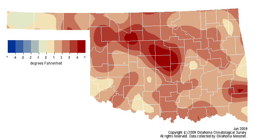
The statewide average temperature for the month finished at 78.6 degrees, 2.1
degrees above normal, which ranks it as the 26th warmest since 1895. June's
numbers boost the year-to-date statewide average to 56.4 degrees, 1.1 degrees
above normal and the 29th warmest January-June period on record.

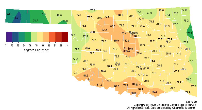
Here are the average temperature and the departure from normal state maps for your
perusal. Notice the hot temperatures from north central through central Oklahoma.
I would proffer forth a theory that was possibly due to the maturing wheat crop
and in some cases, the lack thereof due to previous drought and freeze conditions.
The Oklahoma Hotbox strikes again. The highest temperature in the state was
106 degrees from Fairview on the 27th and the coolest reading of 43 degrees
came in from Boise City on the 8th.

Wait, did I say "proffer"? It's the heat I tell ya!


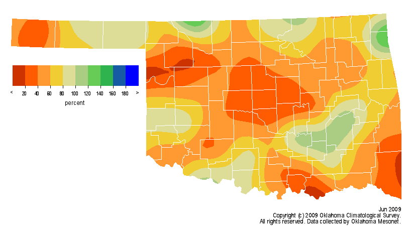
The rainfall statistics were equally dismal. Remember, this is coming off two
wet Junes in a row (2007 was the wettest on record, 2008 ranked 25th). The
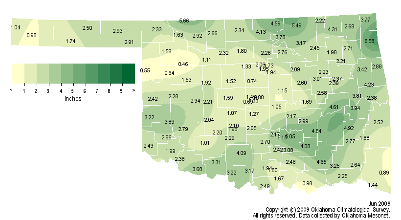
statewide average precipitation total was 2.55 inches, 1.71 inches below normal
and ranked as the 27th driest on record. That puts us 2.47 inches below average
for the year thus far at 16.68 inches, the 50th driest January-June since 1895.
The Panhandle and west central sections are suffering the most with deficits
of 4.47 inches and 5.40 inches since January 1, respectively. That's the 16th-
and 24th-driest such periods on record...again respectively. The Mesonet station
at Jay recorded the most precipitation for the month with 6.58 inches. Seiling
came in on the low end at 0.46 inches. That makes my throat dry just thinking
about it. Here's a look at the precipitation maps for June.


So a pretty pathetic beginning for summer as we enter July and August, our two
hottest and driest (of the warm season) months. Drought is continuing to creep
across the state with moderate drought conditions indicated over most of the
northwestern quadrant of the state.

You can read more about June's climate when our full report comes out in a few
days, as well as look at past months' weather here:

http://climate.mesonet.org/monthly_summary.html

Putting the TWIT in TWITTER!

Since we don't get to Tick much, we figured Twitter might be a bit easier to get
the word out when something interesting comes along, so we created a Twitter
page for the Ticker:

http://twitter.com/ocsticker

So follow us and we'll follow you? Is that how it works? We're not always sure
about the vernacular of the kids these days, so just play along. And how do you get
this "12:00" to quit flashing? Why, back in my day...

Gary McManus
Associate State Climatologist
Oklahoma Climatological Survey
July 1 in Mesonet History
| Record | Value | Station | Year |
|---|---|---|---|
| Maximum Temperature | 110°F | ALVA | 1997 |
| Minimum Temperature | 50°F | EVAX | 2017 |
| Maximum Rainfall | 5.82 inches | PAWN | 2016 |
Mesonet records begin in 1994.
Search by Date
If you're a bit off, don't worry, because just like horseshoes, “almost” counts on the Ticker website!