Ticker for November 4, 2008
MESONET TICKER ... MESONET TICKER ... MESONET TICKER ... MESONET TICKER ...
November 4, 2008 November 4, 2008 November 4, 2008 November 4, 2008
News Flash: It's Windy
The isobars have conspired against us, bringing stiff winds
today. Here's a map which shows pressure (colors and contours)
along with wind barbs and some wind gust values (the numbers,
in mph) at 1:15 pm:
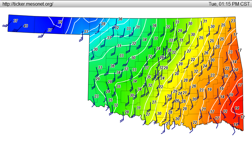
The map helps show a good basic concept from Weather 101:
The pressure gradient (the magnitude of pressure difference from
place to place) drives the speed of the winds (stronger pressure
gradient = windier day). However, due to the rotation of the
earth (the "Coriolis Effect"), the winds are actually deflected
from blowing down the pressure gradient (across the contour lines),
and instead blow across the gradient (along the contour lines).
In an ideal rotating world, winds blow happily along the pressure
contours.
But, as you see in our map, the winds actually blow slightly
across the contours from high to low pressure. This is due
partially to friction, which always messes up any "ideal world"
scenario (thanks a lot, friction, you buzzkill).
But it is also due to the rapidly decreasing pressure associated
with the development of a trough/system in the lee of the Rockies.
The rapid change out west will strengthen the pressure gradient,
but it is initially "too quick" for the Coriolis Effect to "react"
(the Coriolis Effect, being tied to the earth's rotation, takes
about one day to fully take effect). Therefore, winds will show a
cross-contour component as long as the deepening pressure out west
outpaces the Coriolis Effect.
November 4 in Mesonet History
| Record | Value | Station | Year |
|---|---|---|---|
| Maximum Temperature | 91°F | MANG | 2005 |
| Minimum Temperature | 17°F | CAMA | 2011 |
| Maximum Rainfall | 4.77 inches | VALL | 2024 |
Mesonet records begin in 1994.
Search by Date
If you're a bit off, don't worry, because just like horseshoes, “almost” counts on the Ticker website!