Ticker for June 4, 2008
MESONET TICKER ... MESONET TICKER ... MESONET TICKER ... MESONET TICKER ...
June 4, 2008 June 4, 2008 June 4, 2008 June 4, 2008
Strong Straight-Line Winds in Northern OK
A whopper of a thunderstorm trekked across Oklahoma's northern tier
of counties yesterday, delivering powerful, damaging straight-line
winds.
Station Wind Gust Time Station Wind Gust Time
Freedom 75 mph 7:20 pm Freedom 74 mph 7:15 pm
Newkirk 73 mph 9:30 pm Freedom 68 mph 7:25 pm
Foraker 67 mph 10:00 pm Newkirk 66 mph 9:20 pm
May Ranch 63 mph 7:25 pm Freedom 63 mph 7:10 pm
Medford 59 mph 8:45 pm May Ranch 58 mph 7:35 pm
Buffalo 57 mph 6:55 pm Slapout 56 mph 6:05 pm
Copan 55 mph 10:20 pm Goodwell 55 mph 4:35 pm
Kenton 54 mph 8:00 pm Freedom 54 mph 7:30 pm
May Ranch 54 mph 7:30 pm Burbank 53 mph 9:40 pm
Blackwell 53 mph 9:10 pm Medford 53 mph 8:40 pm
Copan 51 mph 10:30 pm Burbank 51 mph 9:45 pm
Newkirk 51 mph 9:40 pm Newkirk 51 mph 9:35 pm
Foraker 50 mph 10:05 pm Blackwell 50 mph 9:05 pm
Colliding Boundaries
Here's a picture of the pre-storm setup in the area. It should also
yield the locations of the Mesonet stations in the above list:
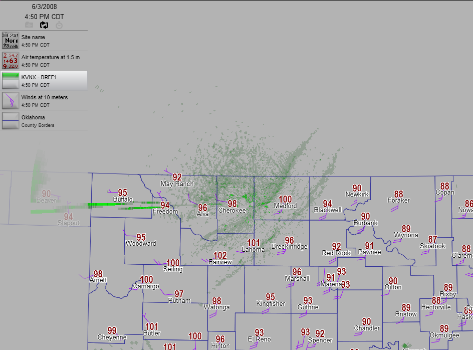
The storm, already mature, was still beyond the western end of the
radar scope. But what's interesting in this graphic are the double
boundaries right over the radar site. Each of these lines, draped
southwest-to-northeast represents a boundary of some sort. The
southern one is a dry line, and the northern one is a "cold" front
(it separates 100F temps from mid-90s temps!).
Notice the very hot temps in the skinny "dry slot" between the two
boundaries! A small stripe of higher temps paints Fairview, Lahoma
and Medford.
Boundaries are important because they are focal points for storms
when the atmosphere is in the mood to produce storms.
The cold front overtook the dry line a few minutes later (and spawned
a few more storms!).
June 4 in Mesonet History
| Record | Value | Station | Year |
|---|---|---|---|
| Maximum Temperature | 107°F | GRA2 | 2014 |
| Minimum Temperature | 43°F | EVAX | 2025 |
| Maximum Rainfall | 8.23 inches | GRAN | 1995 |
Mesonet records begin in 1994.
Search by Date
If you're a bit off, don't worry, because just like horseshoes, “almost” counts on the Ticker website!