Ticker for May 8, 2008
MESONET TICKER ... MESONET TICKER ... MESONET TICKER ... MESONET TICKER ...
May 8, 2008 May 8, 2008 May 8, 2008 May 8, 2008
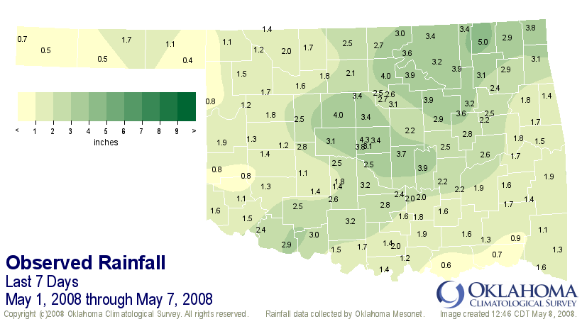
It's Not A Lot, But It's A Start
During the last week, while most of Oklahoma's "downstaters" were dodging
tornadoes, severe weather, flash-flooding and the typical weather hassles
of May, something good very positive took place in the panhandle. More
than half-an-inch of rain fell on most of the panhandle, with some
locations seeing more than an inch.
And this is good news for the region, which has been struggling with
droughty conditions for several months going.
Is it enough to erase drought? Of course not. But it does help!
Well, Actually, It *Is* A Lot
On second look, statewide, the first seven days of May were the wettest
we've seen since the beginning of robust daily records in 1921. And, while
no single sector of the state set a superlative, the statewide total
of 3.84" was enough to pass the old mark of 3.47" in 1990.
Here's a map of the seven-day totals:
May 8 in Mesonet History
| Record | Value | Station | Year |
|---|---|---|---|
| Maximum Temperature | 108°F | ALTU | 2011 |
| Minimum Temperature | 34°F | CHER | 2010 |
| Maximum Rainfall | 5.86 inches | FTCB | 2007 |
Mesonet records begin in 1994.
Search by Date
If you're a bit off, don't worry, because just like horseshoes, “almost” counts on the Ticker website!