Ticker for June 11, 2007
MESONET TICKER ... MESONET TICKER ... MESONET TICKER ... MESONET TICKER ...
June 11, 2007      June 11, 2007      June 11, 2007      June 11, 2007


But it's a dry heat ... yeah, right.

We're heading into that time of year: summer. We're not gonna lie to you:
something about today's hot, humid, tropical air makes it hard to even
reach for the remote. We have recent rains to thank for our absurd
dewpoints.

But it's a dry heat, part 2

Speaking of moisture and temperature, we're also entering the time of
year when they are nearly inextricable from each other, in a climate
sense. This whole week, we'll examine the climatological relationship
between rainfall and temperature.

Today, we'll start with the obvious:

During the summer in Oklahoma, cooler months are strongly
correlated with wetter months.

This, of course, has to do with the partitioning of downwelling sunlight
into two categories:
a. sensible heating (raising the temperature of the surface),
b. latent heating (evaporation of water).

It's easiest just to think of this concept in budgetary terms. When
there's a lot of water in the soils (like today, for instance), the sun
will "spend" more of its budget on evaporation; consequently, it will
"spend" less on raising the surface temperature.

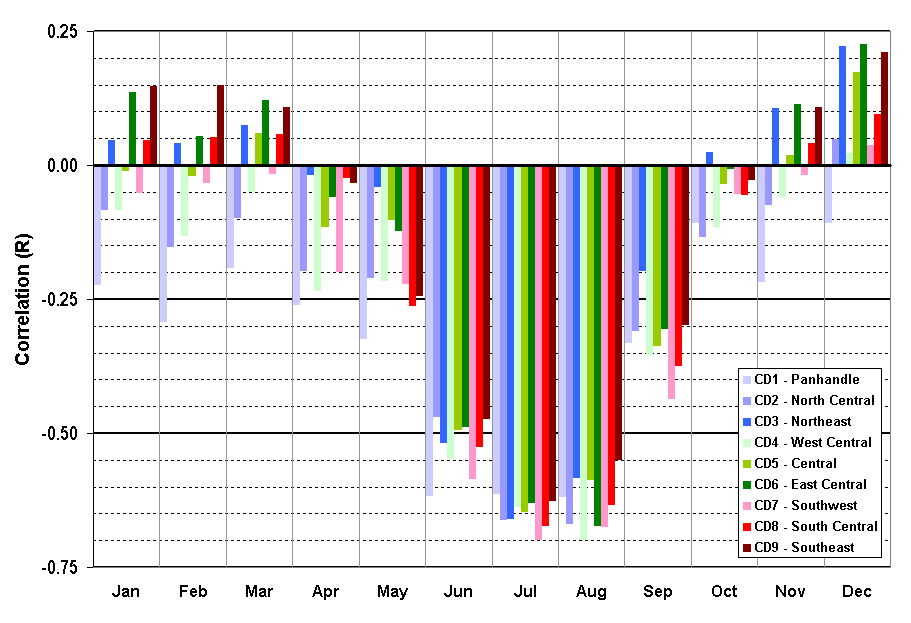
While this all seems perfectly natural, the summer months are our only
months when rainfall and temperature are strongly correlated. Here's
a graphic that shows the relationship (correlation) on a monthly basis:


Yes, it's a very busy graphic, because each of Oklahoma's nine climate
divisions gets its own line for each month. But the overall picture is
unmistakable: correlations are small for most of the year, then become
strongly negative in summer, peaking in July and August. A strong
negative correlation implies a strong relationship with opposite sign
(in other words, when precip goes up, temp goes down; and vice versa).

So, why is this the case only in the summer? A couple of reasons:

1. There's a lot more sunlight to be divided up!

2. More importantly, during the summer months, large scale systems
tend to stay north of us, and we get caught in the doldrums, with
little synoptic-scale umph to move air masses around. Consequently,
local effects take over, and saturated soils means lots of
evaporation and lower temps.
June 11 in Mesonet History
| Record | Value | Station | Year |
|---|---|---|---|
| Maximum Temperature | 108°F | ALTU | 2022 |
| Minimum Temperature | 44°F | KENT | 2004 |
| Maximum Rainfall | 6.05″ | COPA | 2007 |
Mesonet records begin in 1994.
Search by Date
If you're a bit off, don't worry, because just like horseshoes, “almost” counts on the Ticker website!